imported>Mirca |
imported>FippeBot |
| (4 intermediate revisions by 2 users not shown) |
| Line 1: |
Line 1: |
| | | | |
| − | <!-- If you did not specify these parameters in the template, please substitute appropriate values for IMAGE, LAT, LON, and DATE (YYYY-MM-DD format)
| |
| − |
| |
| − | [[Image:{{{image|IMAGE}}}|thumb|left]]
| |
| − |
| |
| − | Remove this section if you don't want an image at the top (left) of your report. You should remove the "Image:" or "File:"
| |
| − | tag from your image file name, and replace the all upper-case word IMAGE in the above line.
| |
| − |
| |
| − | And DON'T FORGET to add your expedition and the best photo you took to the gallery on the Main Page! We'd love to read your report, but that means we first have to discover it! :)
| |
| − | -->
| |
| | {{meetup graticule | | {{meetup graticule |
| − | | lat=62.8509933 | + | | lat=62 |
| − | | lon=27.4917226 | + | | lon=27 |
| | | date=2014-06-08 | | | date=2014-06-08 |
| | }} | | }} |
| | | | |
| − | <!-- edit as necessary -->
| + | |
| | __NOTOC__ | | __NOTOC__ |
| | + | |
| | == Location == | | == Location == |
| − | <!-- where you've surveyed the hash to be -->
| + | |
| | + | In the thick spruce forest, near the village of Haminalahti. About 20 km from the centrum of Kuopio |
| | | | |
| | == Participants == | | == Participants == |
| − | <!-- who attended: If you link to your wiki user name in this section, your expedition will be picked up by the various statistics generated for geohashing. You may use three tildes ~ as a shortcut to automatically insert the user signature of the account you are editing with.
| + | |
| − | -->
| + | * [[User:Mirca|Mirca]] and |
| | + | * her son |
| | | | |
| | == Plans == | | == Plans == |
| − | <!-- what were the original plans -->
| + | |
| | + | It was sunny Sunday evening. We were driving home from my relatives, and decided to visit the |
| | + | meetup point which was near our route. |
| | | | |
| | == Expedition == | | == Expedition == |
| − | <!-- how it all turned out. your narrative goes here. -->
| |
| − |
| |
| − | == Tracklog ==
| |
| − | <!-- if your GPS device keeps a log, you may post a link here -->
| |
| − |
| |
| − | == Photos ==
| |
| − | <!-- Insert pictures between the gallery tags using the following format:
| |
| − | Image:2012-##-## ## ## Alpha.jpg | Witty Comment
| |
| − | -->
| |
| − | <gallery perrow="5">
| |
| − | </gallery>
| |
| | | | |
| − | == Achievements ==
| + | We were driving from Karttula toward the city of Kuopio. We turned to the road 5550 leading into the village of Haminalahti. We passed the village and turned left to the sand road named Jalkalantie. The road went through the forest and also passed some nice farmhouses. |
| − | {{#vardefine:ribbonwidth|800px}}
| |
| − | <!-- Add any achievement ribbons you earned below, or remove this section -->
| |
| | | | |
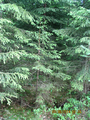
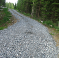
| | + | After about 2 km road was paved with very rough gravel. Fortunately we were quite near to the point. We left the car and walked 30 m from the road through the very thick spruce forest. The meetup point was there on a little nice clearing. |
| | + | We liked it was very easy to get to that hashpoint. |
| | | | |
| − | <!-- =============== USEFUL CATEGORIES FOLLOW ================
| + | It was not so easy to started driving home. The car was on the bumpy ground of the roadside, and it needed some hard pushing before we got it to the road. |
| − | Delete the next line ONLY if you have chosen the appropriate categories below. If you are unsure, don't worry. People will read your report and help you with the classification.-->
| |
| − | [[Category:New report]]
| |
| | | | |
| − | <!-- ==REQUEST FOR TWITTER BOT== Please leave either the New report or the Expedition planning category in as long as you work on it. This helps the twitter bot a lot with announcing the right outcome at the right moment. -->
| + | == Photos == |
| | | | |
| − | <!-- Potential categories. Please include all the ones appropriate to your expedition -->
| |
| − | <!-- If this is a planning page:
| |
| − | [[Category:Expedition planning]]
| |
| − | -->
| |
| − |
| |
| − | <!-- An actual expedition:
| |
| − | [[Category:Expeditions]]
| |
| − | -- and one or more of --
| |
| − | [[Category:Expeditions with photos]]
| |
| − | [[Category:Expeditions with videos]]
| |
| − | [[Category:Expedition without GPS]]
| |
| − | -->
| |
| − |
| |
| − | <!-- if you reached your coords:
| |
| − | [[Category:Coordinates reached]]
| |
| − |
| |
| − |
| |
| − | --><!-- or if you failed :(
| |
| − | [[Category:Coordinates not reached]]
| |
| − | -- and a reason --
| |
| − | When there is a natural obstacle between you and the target:
| |
| − | [[Category:Not reached - Mother Nature]]
| |
| − |
| |
| − | When there is a man-made obstacle between you and the target:
| |
| − | [[Category:Not reached - No public access]]
| |
| − |
| |
| − | When you failed get your GPS, car, bike or such to work:
| |
| − | [[Category:Not reached - Technology]]
| |
| − |
| |
| − | When you went to an alternate location instead of the actual geohash:
| |
| − | [[Category:Not reached - Did not attempt]]
| |
| − |
| |
| − | (Don't forget to delete this final close comment marker) -->
| |
| − |
| |
| − |
| |
| − | == Location ==
| |
| − | <!-- where you've surveyed the hash to be -->
| |
| − | In the thick spruce forest, near the village of Haminalahti. About 20 km from the centrum of Kuopio
| |
| − |
| |
| − | == Participants ==
| |
| − | <!-- who attended: If you link to your wiki user name in this section, your expedition will be picked up by the various statistics generated for geohashing. You may use three tildes ~ as a shortcut to automatically insert the user signature of the account you are editing with.
| |
| − | -->
| |
| − | Mirca and her son.
| |
| − |
| |
| − | == Plans ==
| |
| − | <!-- what were the original plans -->
| |
| − | It was sunny Sunday evening. We were driving home from my relatives, and decided to visit the meetup point which was near our route
| |
| − |
| |
| − | == Expedition ==
| |
| − | <!-- how it all turned out. your narrative goes here. -->
| |
| − | We were driving from Karttula toward the city of Kuopio. We turned to the road 5550 leading into the village of Haminalahti. We passed the village and turned left to the sand road named Jalkalantie. The road went through the forest and also passed some nice farmhouses. After about 2 km road was paved with very rough gravel. Fortunately we were quite near to the point. We left the car and walked 30 m from the road through the very thick spruce forest. The meetup point was there on a little nice clearing.
| |
| − | We liked it was very easy to get to that hashpoint. It was not so easy to start driving home. The car was on the bumpy ground of the roadside, and it needed some hard pushing before we got it to the road.
| |
| − |
| |
| − | == Photos ==
| |
| − | <!-- Insert pictures between the gallery tags using the following format:
| |
| − | Image:2012-##-## ## ## Alpha.jpg | Witty Comment
| |
| − | -->
| |
| | <gallery perrow="5"> | | <gallery perrow="5"> |
| | | | |
| Line 116: |
Line 42: |
| | | | |
| | </gallery> | | </gallery> |
| | + | |
| | + | == Achievements == |
| | + | |
| | + | * Land Geohash |
| | + | |
| | + | [[Category:Expeditions]] |
| | + | [[Category:Expeditions with photos]] |
| | + | [[Category:Coordinates reached]] |
| | + | {{location|FI|15}} |
Location
In the thick spruce forest, near the village of Haminalahti. About 20 km from the centrum of Kuopio
Participants
Plans
It was sunny Sunday evening. We were driving home from my relatives, and decided to visit the
meetup point which was near our route.
Expedition
We were driving from Karttula toward the city of Kuopio. We turned to the road 5550 leading into the village of Haminalahti. We passed the village and turned left to the sand road named Jalkalantie. The road went through the forest and also passed some nice farmhouses.
After about 2 km road was paved with very rough gravel. Fortunately we were quite near to the point. We left the car and walked 30 m from the road through the very thick spruce forest. The meetup point was there on a little nice clearing.
We liked it was very easy to get to that hashpoint.
It was not so easy to started driving home. The car was on the bumpy ground of the roadside, and it needed some hard pushing before we got it to the road.
Photos
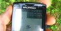
The meeting point in the middle of the clearing
Spruces grow very thickly
The road with some gravel
Achievements