Difference between revisions of "2014-06-09 48 8"
imported>RecentlyChanged (→Expedition) |
m |
||
| (5 intermediate revisions by 4 users not shown) | |||
| Line 1: | Line 1: | ||
| − | |||
| − | |||
| − | |||
| − | |||
| − | |||
| − | |||
| − | |||
| − | |||
| − | |||
| − | |||
{{meetup graticule | {{meetup graticule | ||
| lat=48 | | lat=48 | ||
| Line 45: | Line 35: | ||
But! Did I mention, before I encountered all this problems, I made a beautiful hashmarker. I burned with my fathers electric soldering bolt the letters into a old timber shingle (as seen below). My first hashmarker ever... | But! Did I mention, before I encountered all this problems, I made a beautiful hashmarker. I burned with my fathers electric soldering bolt the letters into a old timber shingle (as seen below). My first hashmarker ever... | ||
| − | |||
| − | |||
| − | |||
== Photos == | == Photos == | ||
| Line 60: | Line 47: | ||
== Achievements == | == Achievements == | ||
{{#vardefine:ribbonwidth|800px}} | {{#vardefine:ribbonwidth|800px}} | ||
| − | + | {{Prize poultry | |
| − | |||
| − | + | | latitude = 48 | |
| − | + | | longitude = 8 | |
| − | + | | date = 2014-06-09 | |
| + | | name = RecentlyChanged | ||
| + | | reason = he was tired and out of technology | ||
| + | }} | ||
| − | |||
| − | |||
| − | |||
| − | |||
| − | |||
| − | |||
| − | |||
| − | |||
| − | |||
| − | |||
[[Category:Expeditions with photos]] | [[Category:Expeditions with photos]] | ||
| − | |||
| − | |||
| − | |||
| − | |||
| − | |||
| − | |||
| − | |||
| − | |||
| − | |||
[[Category:Coordinates not reached]] | [[Category:Coordinates not reached]] | ||
| − | |||
| − | |||
| − | |||
| − | |||
| − | |||
| − | |||
| − | |||
| − | |||
| − | |||
| − | |||
| − | |||
[[Category:Not reached - Did not attempt]] | [[Category:Not reached - Did not attempt]] | ||
| − | + | {{location|DE|BW|OG}} | |
| − | |||
Latest revision as of 21:25, 14 March 2022
| Mon 9 Jun 2014 in 48,8: 48.2230417, 8.2464164 geohashing.info google osm bing/os kml crox |
Location
In Hornberg, a little city, dejá-vu?
Participants
RecentlyChanged
Plans
Making a nice marker, grab the bicycle even though it's late and a horrible far way to get back!
Expedition
There was no expedition! :(
I've seen the Hash and thought: "Yes!! First possible dejà-vu, because I came through there already on another geohash.
But! I was really really sleepy, because I just came home from a festival after I drove almost seven hours and just slept a few hours the days before (Rock am Ring).
Still I wanted to Hash.
But! My family where not at home and I left my GPS-device in Karlsruhe, so I had no GPS. Neither did I had my smartphone, because I left it in Karlsruhe too (I use an old bone as cellphone on festivals, you know...). But I did not want to give up! So I pm'd a geocacher from our village I know. He would have helped me, but he is in czechia with his family.
Ok, then I'll make one without GPS, it is an easy to proof location, I just need a good photo of the location.
But! For a photo of the location, I need a camera!! Damn, where in our **** *** *** house do we have a camera? Even our friendly neighbours which I could have asked, where on vacation! Ok, f*** it. I will not go to the Hash!
But! Did I mention, before I encountered all this problems, I made a beautiful hashmarker. I burned with my fathers electric soldering bolt the letters into a old timber shingle (as seen below). My first hashmarker ever...
Photos
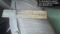
The beautiful marker I made!

Achievements
RecentlyChanged earned the Prize poultry Consolation Prize
|