Difference between revisions of "2014-06-15 48 7"
imported>DODO (→Location) |
imported>FippeBot m (Location) |
||
| (8 intermediate revisions by one other user not shown) | |||
| Line 24: | Line 24: | ||
<!-- who attended: If you link to your wiki user name in this section, your expedition will be picked up by the various statistics generated for geohashing. You may use three tildes ~ as a shortcut to automatically insert the user signature of the account you are editing with. | <!-- who attended: If you link to your wiki user name in this section, your expedition will be picked up by the various statistics generated for geohashing. You may use three tildes ~ as a shortcut to automatically insert the user signature of the account you are editing with. | ||
--> | --> | ||
| + | [[User:DODO|DODO]] ([[User talk:DODO|talk]]) | ||
== Plans == | == Plans == | ||
<!-- what were the original plans --> | <!-- what were the original plans --> | ||
| + | To take the train to Germersheim at 9:32 and continue my travel from there by bike. After I've visited the hashpoint I'll ride on to Rastatt and take the train home from there. | ||
== Expedition == | == Expedition == | ||
<!-- how it all turned out. your narrative goes here. --> | <!-- how it all turned out. your narrative goes here. --> | ||
| + | So, after the short expedition [[2014-06-14_49_8 | yesterday]], todays trip was epic again. The way, my legs felt after the 70 KM trip yesterday, it was clear, that I wouldn't make a 100 + KM on my bike today. So first of all, I decided to ride my bull, and second, I expanded the train-part to Wörth. | ||
| + | |||
| + | Soon I reached the french border but didn't cross it immediately but stayed on the German side till Scheibenhardt(D)/Scheibenhard(F).Now followed a lot of little french villages, all even prettier but also more dozily than the palatine villages. I came along a former jewish cemetery where I had a little rest and took some photos. After a while I reached a former rail track, where I could ride really fast, but soon after that I reached the busy D263. First I tried to avoid the road by taking a path through the forest, but it ended after a while and so I had to take the road anyway. But only some minutes later I came near the hashpoint and had to try to get there. As the forest seemed very dense and there was a ditch between the road and the forest, it was clear that I couldn't take my bull with me. So I returned some 100 meters and put the bull in a forest path to walk on by foot. I found a way to enter the bushes, but after the first row the forest became quite light and easy passable. | ||
| + | |||
| + | To find the hashpoint, I had to do some dancing, as accuracy was bad in the forest. Anyway, I did it somehow. I had some food with me, fruits again, but also some french pastry and some water, and I even foud a place to arrange it and to sit down. I think, this time, it is good enough for a picnic. | ||
| + | Before I left again, I left a marker, if in a far future geohashing will come famous in france. | ||
| + | |||
| + | Then I walked back to my bike and returned along the road and back to the rail track. This time I could stay even longer on it. I found a bunker of the ligne maginot but stayed only a short time to take some photos. It doesn't take long and I reached a bridge over the river rhine on which I returned to germany and continued to Rastatt. I knew that there was a train at 14:34 from Rastatt and so I hurried to the station, oon which I arrived at 14:37, but the train was still there. Nevertheless, I still had to buy a ticket, and just when I finished that the train started. But that was good luck for me, because so I had the occasion to ride to the city of Rastatt. At the castle there was a festival for the 300. anniversary of the [http://en.wikipedia.org/wiki/Treaty_of_Rastatt Treaty of Rastatt], where I listened to some music and ate some Ochsenmaulsalat (ox-muzzle salad) and drank some beer. | ||
| + | |||
| + | Back to the station I was told, that the train from Graben-Neudorf wouldn't stop in Speyer today due to a building site. So I left the train in Graben-Neudorf and went to Germersheim by bike once again. | ||
== Tracklog == | == Tracklog == | ||
<!-- if your GPS device keeps a log, you may post a link here --> | <!-- if your GPS device keeps a log, you may post a link here --> | ||
| + | [http://www.gpsies.com/map.do?fileId=cysuuxxmlixwrodu 112 KM by bull and 90 KM by train] | ||
== Photos == | == Photos == | ||
| Line 38: | Line 51: | ||
Image:2012-##-## ## ## Alpha.jpg | Witty Comment | Image:2012-##-## ## ## Alpha.jpg | Witty Comment | ||
--> | --> | ||
| − | <gallery perrow=" | + | <gallery perrow="6"> |
| + | Image:2014-06-15_48_7-1.jpg | french border, but not to cross here | ||
| + | Image:2014-06-15_48_7-2.jpg | french border again | ||
| + | Image:2014-06-15_48_7-3.jpg | a former jewish cemetery | ||
| + | Image:2014-06-15_48_7-4.jpg | old tombstones | ||
| + | Image:2014-06-15_48_7-5.jpg | twild strawberries again | ||
| + | Image:2014-06-15_48_7-6.jpg | parking the bull | ||
| + | Image:2014-06-15_48_7-7.jpg | looks dense | ||
| + | Image:2014-06-15_48_7-8.jpg | but after the first row... | ||
| + | Image:2014-06-15_48_7-9.jpg | proof | ||
| + | Image:2014-06-15_48_7-10.jpg | obligatory | ||
| + | Image:2014-06-15_48_7-11.jpg | picnic | ||
| + | Image:2014-06-15_48_7-12.jpg | marker | ||
| + | Image:2014-06-15_48_7-13.jpg | ligne maginot | ||
| + | Image:2014-06-15_48_7-14.jpg | the bridge to germany | ||
| + | Image:2014-06-15_48_7-15.jpg | castle Rastatt | ||
| + | Image:2014-06-15_48_7-16.jpg | Ochsenmaulsalat, delicious | ||
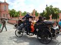
| + | Image:2014-06-15_48_7-17.jpg | very old car | ||
| + | Image:2014-06-15_48_7-18.jpg | caslte Rastatt with festival | ||
</gallery> | </gallery> | ||
| Line 45: | Line 76: | ||
<!-- Add any achievement ribbons you earned below, or remove this section --> | <!-- Add any achievement ribbons you earned below, or remove this section --> | ||
| + | {{land geohash | ||
| − | + | | latitude = 48 | |
| − | + | | longitude = 7 | |
| − | + | | date = 2014-06-15 | |
| + | | name = DODO | ||
| + | }} | ||
| − | + | {{Minesweeper geohash | |
| + | | graticule = Mannheim, Germany | ||
| + | | ranknumber = 3 | ||
| + | | s = true | ||
| + | | n = true | ||
| + | | sw = true | ||
| + | | name = DODO | ||
| + | }} | ||
| + | |||
| + | {{Picnic_geohash | ||
| + | | latitude = 48 | ||
| + | | longitude = 7 | ||
| + | | date = 2014-06-15 | ||
| + | | name = DODO | ||
| + | | image = 2014-06-15_48_7-11.jpg | ||
| + | | food = strawberries, a peach, red currant and french pastry | ||
| + | }} | ||
| + | |||
| + | {{consecutive geohash | ||
| + | | count = 2 | ||
| + | | latitude = 49 | ||
| + | | longitude = 8 | ||
| + | | date = 2014-06-14 | ||
| + | | name = DODO | ||
| + | }} | ||
| + | |||
| + | {{Border geohash achievement | ||
| + | | latitude = 48 | ||
| + | | longitude = 7 | ||
| + | | date = 2014-06-15 | ||
| + | | country1 = german | ||
| + | | country2 = french | ||
| + | | name = DODO | ||
| + | | image = 2014-06-15_48_7-2.jpg | ||
| + | }} | ||
| − | |||
| − | |||
| − | |||
| − | |||
| − | |||
[[Category:Expeditions]] | [[Category:Expeditions]] | ||
| − | |||
[[Category:Expeditions with photos]] | [[Category:Expeditions with photos]] | ||
| − | |||
| − | |||
| − | |||
| − | |||
| − | |||
[[Category:Coordinates reached]] | [[Category:Coordinates reached]] | ||
| − | + | {{location|FR|67}} | |
| − | |||
| − | |||
| − | |||
| − | |||
| − | |||
| − | |||
| − | |||
| − | |||
| − | |||
| − | |||
| − | |||
| − | |||
| − | |||
| − | |||
| − | |||
| − | |||
| − | |||
Latest revision as of 06:53, 14 August 2019
| Sun 15 Jun 2014 in 48,7: 48.8659918, 7.8243489 geohashing.info google osm bing/os kml crox |
Location
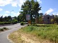
In the forêt du Haguenau next to the D263.
Participants
Plans
To take the train to Germersheim at 9:32 and continue my travel from there by bike. After I've visited the hashpoint I'll ride on to Rastatt and take the train home from there.
Expedition
So, after the short expedition yesterday, todays trip was epic again. The way, my legs felt after the 70 KM trip yesterday, it was clear, that I wouldn't make a 100 + KM on my bike today. So first of all, I decided to ride my bull, and second, I expanded the train-part to Wörth.
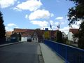
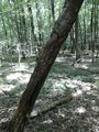
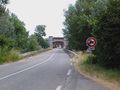
Soon I reached the french border but didn't cross it immediately but stayed on the German side till Scheibenhardt(D)/Scheibenhard(F).Now followed a lot of little french villages, all even prettier but also more dozily than the palatine villages. I came along a former jewish cemetery where I had a little rest and took some photos. After a while I reached a former rail track, where I could ride really fast, but soon after that I reached the busy D263. First I tried to avoid the road by taking a path through the forest, but it ended after a while and so I had to take the road anyway. But only some minutes later I came near the hashpoint and had to try to get there. As the forest seemed very dense and there was a ditch between the road and the forest, it was clear that I couldn't take my bull with me. So I returned some 100 meters and put the bull in a forest path to walk on by foot. I found a way to enter the bushes, but after the first row the forest became quite light and easy passable.
To find the hashpoint, I had to do some dancing, as accuracy was bad in the forest. Anyway, I did it somehow. I had some food with me, fruits again, but also some french pastry and some water, and I even foud a place to arrange it and to sit down. I think, this time, it is good enough for a picnic. Before I left again, I left a marker, if in a far future geohashing will come famous in france.
Then I walked back to my bike and returned along the road and back to the rail track. This time I could stay even longer on it. I found a bunker of the ligne maginot but stayed only a short time to take some photos. It doesn't take long and I reached a bridge over the river rhine on which I returned to germany and continued to Rastatt. I knew that there was a train at 14:34 from Rastatt and so I hurried to the station, oon which I arrived at 14:37, but the train was still there. Nevertheless, I still had to buy a ticket, and just when I finished that the train started. But that was good luck for me, because so I had the occasion to ride to the city of Rastatt. At the castle there was a festival for the 300. anniversary of the Treaty of Rastatt, where I listened to some music and ate some Ochsenmaulsalat (ox-muzzle salad) and drank some beer.
Back to the station I was told, that the train from Graben-Neudorf wouldn't stop in Speyer today due to a building site. So I left the train in Graben-Neudorf and went to Germersheim by bike once again.
Tracklog
112 KM by bull and 90 KM by train
Photos
french border, but not to cross here
french border again
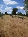
a former jewish cemetery
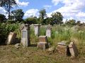
old tombstones
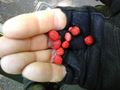
twild strawberries again
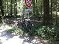
parking the bull
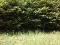
looks dense
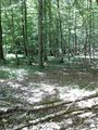
but after the first row...
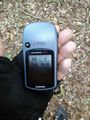
proof
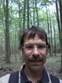
obligatory
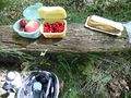
picnic
marker
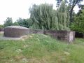
ligne maginot
the bridge to germany
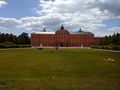
castle Rastatt
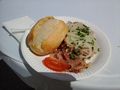
Ochsenmaulsalat, delicious
very old car
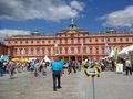
caslte Rastatt with festival


Achievements
DODO earned the Land geohash achievement
|
DODO achieved level 3 of the Minesweeper Geohash achievement
|
DODO earned the Picnic achievement
|
DODO earned the Consecutive geohash achievement
|
DODO earned the Border geohash achievement
|