Difference between revisions of "2014-06-19 -36 145"
imported>Lachie (Created page with " <!-- If you did not specify these parameters in the template, please substitute appropriate values for IMAGE, LAT, LON, and DATE (YYYY-MM-DD format) --> {{meetup graticule...") |
Felix Dance (talk | contribs) m (→Achievements) |
||
| (6 intermediate revisions by 4 users not shown) | |||
| Line 22: | Line 22: | ||
Arriving in Murchison East at 3pm I set off on my bike for the ~20km ride to the hash. The first thing of note that I saw was a letter box shaped like a horse float. | Arriving in Murchison East at 3pm I set off on my bike for the ~20km ride to the hash. The first thing of note that I saw was a letter box shaped like a horse float. | ||
| − | |||
| − | I continued to zigzag through the back roads finding myself at a rather muddy road that appeared to only be | + | I continued to zigzag through the back roads finding myself very close to the hash at a rather muddy road that appeared to only be frequented by tractors. Perfect more my road bike. I rode a few hundred metres down the mud road to find roads even less suitable. I had planned my route based on satellite images but the short section of grass I had to cross turned out to be a 3m wide irrigation channel and the road on the other side was a fence. I backtracked and went down the driveway of the farm to the dairy where I was greeted by a friendly dog. |
| + | After getting permission from the land owner who was busy milking his cows I walked through a swamp, jumped an irrigation channel(slightly narrowed than the previous one), climbed a fence and I was there. I surveyed my surroundings to find I could have taken a different driveway all the way there and that the swamp was right next to a silage pit and I had been probably been knee deep in poo. Geohash success at 4:42pm. | ||
| + | |||
| + | From there I continued on my bike ride to Wangaratta via Dookie Rail Trail, Wangaratta and Bright. Total distance 338km in 22 hours with highlights including: | ||
| + | |||
| + | -Doing a dookie in Dookie | ||
| + | |||
| + | -Drinking 1.5L of ice coffee in Wangaratta my first time through | ||
| + | |||
| + | -Accidentally going mountain biking in Porepunkah at 5am | ||
| + | |||
| + | -Making back to Wangaratta in time for the train. | ||
| + | |||
| + | Lowlights: | ||
| + | |||
| + | -Bright Brewery not being open at 6:30am | ||
| + | |||
| + | EDIT: turns out Sheparton was not a virgin graticule. | ||
== Photos == | == Photos == | ||
| − | |||
| − | |||
| − | |||
<gallery perrow="5"> | <gallery perrow="5"> | ||
| − | Image: | + | Image:2014-06-19_-36_145_cowselfie.jpg| Cow selfie at the hash. |
| − | + | Image:2014-06-19_-36_145_dark.jpg| It was dark in Bright. | |
| − | + | Image:2014-06-19_-36_145_dog.jpg| Hash Dog. | |
| + | Image:2014-06-19_-36_145_gps.png| Proof. | ||
| + | Image:2014-06-19_-36_145_letter.jpg| A nice letter box. | ||
| + | Image:2014-06-19_-36_145_noroad.jpg| That's no road. | ||
| + | Image:2014-06-19_-36_145_road.jpg| Mud. | ||
| + | Image:2014-06-19_-36_145_silage.jpg| A silage pit. | ||
| + | |||
| Line 44: | Line 63: | ||
== Achievements == | == Achievements == | ||
{{#vardefine:ribbonwidth|800px}} | {{#vardefine:ribbonwidth|800px}} | ||
| − | |||
| + | {{bicycle geohash | ||
| + | |||
| + | | latitude = -36 | ||
| + | | longitude = 145 | ||
| + | | date = 2014-06-19 | ||
| + | | name = [[User:Lachie|Lachie]] | ||
| + | | distance = 338 kms | ||
| + | | bothways = | ||
| + | | image = 2014-06-19 -36 145 cowselfie.jpg | ||
| + | |||
| + | }} | ||
| − | |||
| − | |||
[[Category:Expeditions]] | [[Category:Expeditions]] | ||
[[Category:Expeditions with photos]] | [[Category:Expeditions with photos]] | ||
[[Category:Coordinates reached]] | [[Category:Coordinates reached]] | ||
| + | {{location|AU|VIC|GS}} | ||
Latest revision as of 00:56, 1 June 2022
| Thu 19 Jun 2014 in -36,145: -36.4669509, 145.2812501 geohashing.info google osm bing/os kml crox |
Location
On a dairy farm, near Tatura
Participants
Expedition
I had my last exam for the semester on Thursday and had been feeling a little restless from too much time inside and not enough crazy bike rides, Shepparton graticule was a virgin graticule and there were a few rail trails in the area I wanted to ride on. I got up early before my exam checked the coordinates, planned a route and packed what I would need for a long ride. After my exam I went home to change clothes, bought some gloves at Kmart and some supplies at the vic market and made it to Southern Cross station for the 12:52 train to Shepparton with plenty of time to spare.
Arriving in Murchison East at 3pm I set off on my bike for the ~20km ride to the hash. The first thing of note that I saw was a letter box shaped like a horse float.
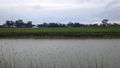
I continued to zigzag through the back roads finding myself very close to the hash at a rather muddy road that appeared to only be frequented by tractors. Perfect more my road bike. I rode a few hundred metres down the mud road to find roads even less suitable. I had planned my route based on satellite images but the short section of grass I had to cross turned out to be a 3m wide irrigation channel and the road on the other side was a fence. I backtracked and went down the driveway of the farm to the dairy where I was greeted by a friendly dog.
After getting permission from the land owner who was busy milking his cows I walked through a swamp, jumped an irrigation channel(slightly narrowed than the previous one), climbed a fence and I was there. I surveyed my surroundings to find I could have taken a different driveway all the way there and that the swamp was right next to a silage pit and I had been probably been knee deep in poo. Geohash success at 4:42pm.
From there I continued on my bike ride to Wangaratta via Dookie Rail Trail, Wangaratta and Bright. Total distance 338km in 22 hours with highlights including:
-Doing a dookie in Dookie
-Drinking 1.5L of ice coffee in Wangaratta my first time through
-Accidentally going mountain biking in Porepunkah at 5am
-Making back to Wangaratta in time for the train.
Lowlights:
-Bright Brewery not being open at 6:30am
EDIT: turns out Sheparton was not a virgin graticule.
Photos
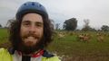
Cow selfie at the hash.

It was dark in Bright.
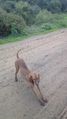
Hash Dog.
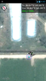
Proof.
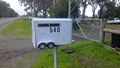
A nice letter box.
That's no road.
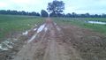
Mud.
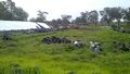
A silage pit.


Achievements
Lachie earned the Bicycle geohash achievement
|