Difference between revisions of "2014-06-21 58 17"
imported>DLichti m (DLichti moved page 2013-06-21 58 17 to 2014-06-21 58 17) |
imported>DLichti (Pictures added) |
||
| Line 1: | Line 1: | ||
| + | [[Image:{{{image|2014-06-21_58_17_overview.jpg}}}|thumb|left]] | ||
| + | |||
{{meetup graticule | {{meetup graticule | ||
| lat=58 | | lat=58 | ||
| Line 11: | Line 13: | ||
== Participants == | == Participants == | ||
| − | [[User:DLichti|DLichti]] | + | [[User:DLichti|DLichti]] |
== Expedition == | == Expedition == | ||
| Line 18: | Line 20: | ||
After eating my lunch, I started exploring the peninsula with its different rock formations. I thought that a map that I saw earlier mentioned a cave. But all I could find was a 1m deep hole in the rock. I don't think, this qualifies for a cave. | After eating my lunch, I started exploring the peninsula with its different rock formations. I thought that a map that I saw earlier mentioned a cave. But all I could find was a 1m deep hole in the rock. I don't think, this qualifies for a cave. | ||
| − | At 16:20, I left the site. Since the last bus left from Lövhagen at 16:00, I chose to walk back to the train station in Nynäshamn. There is a very nice scenic road that curls along the coast | + | At 16:20, I left the site. Since the last bus left from Lövhagen at 16:00, I chose to walk back to the train station in Nynäshamn. There is a very nice scenic road that curls along the coast. After a nice 6km walk, I reached the station where the train already waited for me. 90 minutes later, I was home again. |
| − | |||
| − | |||
| − | |||
== Photos == | == Photos == | ||
| Line 28: | Line 27: | ||
--> | --> | ||
<gallery perrow="5"> | <gallery perrow="5"> | ||
| + | Image:2014-06-21_58_17_location.png | found it... | ||
| + | Image:2014-06-21_58_17_hashpoint.jpg | The bush approximately marks the position of the hash point. | ||
| + | Image:2014-06-21_58_17_hole.jpg | I wonder, how long it took to drill this hole. | ||
| + | Image:2014-06-21_58_17_Gårdsfjärden.jpg | Panoramic view over Knappelskär and Gårdsfjärden | ||
</gallery> | </gallery> | ||
Revision as of 16:46, 22 June 2014

| Sat 21 Jun 2014 in 58,17: 58.8683451, 17.9321811 geohashing.info google osm bing/os kml crox |
Location
On Knappelskär, a rocky peninsula south of Nynäshamn.
Participants
Expedition
The trip started with a 50km bus ride through the nice country side of southern Stockholms län, I finally reached Lövhagen, the last station on this line. By this time, I was the only passenger in the bus. From Lövhagen, it is a nice 1.7km promenade to Knappelskär. The hash point was at the highest place of the rock, but easy to reach by a small path. I arrived there at about 14:15.
After eating my lunch, I started exploring the peninsula with its different rock formations. I thought that a map that I saw earlier mentioned a cave. But all I could find was a 1m deep hole in the rock. I don't think, this qualifies for a cave.
At 16:20, I left the site. Since the last bus left from Lövhagen at 16:00, I chose to walk back to the train station in Nynäshamn. There is a very nice scenic road that curls along the coast. After a nice 6km walk, I reached the station where the train already waited for me. 90 minutes later, I was home again.
Photos
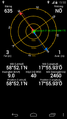
found it...
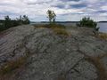
The bush approximately marks the position of the hash point.
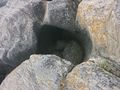
I wonder, how long it took to drill this hole.
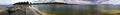
Panoramic view over Knappelskär and Gårdsfjärden


