Difference between revisions of "2014-06-29 40 -74"
From Geohashing
imported>Jevanyn (→Expedition) |
imported>FippeBot m (Location) |
||
| (3 intermediate revisions by one other user not shown) | |||
| Line 19: | Line 19: | ||
== Location == | == Location == | ||
<!-- where you've surveyed the hash to be --> | <!-- where you've surveyed the hash to be --> | ||
| − | Jonathan Road in | + | Jonathan Road in Islen |
== Participants == | == Participants == | ||
<!-- who attended: If you link to your wiki user name in this section, your expedition will be picked up by the various statistics generated for geohashing. You may use three tildes ~ as a shortcut to automatically insert the user signature of the account you are editing with. | <!-- who attended: If you link to your wiki user name in this section, your expedition will be picked up by the various statistics generated for geohashing. You may use three tildes ~ as a shortcut to automatically insert the user signature of the account you are editing with. | ||
--> | --> | ||
| + | *[[User:Jevanyn|Jevanyn]] ([[User talk:Jevanyn|talk]]) | ||
== Plans == | == Plans == | ||
| − | + | I'm in the area on an errand, and I used to live in this neighborhood, so I'm going to swing by and see when the old house looks like. | |
== Expedition == | == Expedition == | ||
| Line 32: | Line 33: | ||
*[[User:Jevanyn|Jevanyn]] ([[User talk:Jevanyn|talk]]): I'll be free this afternoon from 2 to 5:30, if anyone wants to meet up, send me a message through the wiki or Twitter, or say hi with sidewalk chalk :-) Planning a side trip to Oak Ridge Park after the fact. -- [[User:Jevanyn|Jevanyn]] ([[User talk:Jevanyn|talk]]) 07:37, 29 June 2014 (EDT) | *[[User:Jevanyn|Jevanyn]] ([[User talk:Jevanyn|talk]]): I'll be free this afternoon from 2 to 5:30, if anyone wants to meet up, send me a message through the wiki or Twitter, or say hi with sidewalk chalk :-) Planning a side trip to Oak Ridge Park after the fact. -- [[User:Jevanyn|Jevanyn]] ([[User talk:Jevanyn|talk]]) 07:37, 29 June 2014 (EDT) | ||
| + | |||
| + | Reached the geohash, but couldn't identify the house I used to live in. I think it was on Deborah Dr., but I remember the street name being spelled differently (Debra). | ||
== Tracklog == | == Tracklog == | ||
| Line 41: | Line 44: | ||
--> | --> | ||
<gallery perrow="5"> | <gallery perrow="5"> | ||
| + | |||
| + | Image:2014-06-29_40_-74_jevanyn_1404067574388.jpg | In front of the house on Johnathan Rd [http://www.openstreetmap.org/?lat=40.59380000&lon=-74.36280000&zoom=16&layers=B000FTF @40.5938,-74.3628] | ||
| + | |||
| + | Image:2014-06-29_40_-74_jevanyn_1404067569699.jpg | The view down the road [http://www.openstreetmap.org/?lat=40.59380000&lon=-74.36280000&zoom=16&layers=B000FTF @40.5938,-74.3628] | ||
</gallery> | </gallery> | ||
| Line 48: | Line 55: | ||
| − | |||
| − | |||
| − | |||
| − | |||
| − | |||
| − | |||
| − | |||
| − | |||
| − | |||
| − | |||
| − | |||
| − | |||
[[Category:Expeditions]] | [[Category:Expeditions]] | ||
| − | |||
[[Category:Expeditions with photos]] | [[Category:Expeditions with photos]] | ||
| − | |||
| − | |||
| − | |||
| − | |||
| − | |||
[[Category:Coordinates reached]] | [[Category:Coordinates reached]] | ||
| − | + | {{location|US|NJ|MI}} | |
| − | |||
| − | |||
| − | |||
| − | |||
| − | |||
| − | |||
| − | |||
| − | |||
| − | |||
| − | |||
| − | |||
| − | |||
| − | |||
| − | |||
| − | |||
| − | |||
| − | |||
Latest revision as of 00:35, 15 August 2019
| Sun 29 Jun 2014 in 40,-74: 40.5809010, -74.3498212 geohashing.info google osm bing/os kml crox |
Location
Jonathan Road in Islen
Participants
Plans
I'm in the area on an errand, and I used to live in this neighborhood, so I'm going to swing by and see when the old house looks like.
Expedition
- Jevanyn (talk): I'll be free this afternoon from 2 to 5:30, if anyone wants to meet up, send me a message through the wiki or Twitter, or say hi with sidewalk chalk :-) Planning a side trip to Oak Ridge Park after the fact. -- Jevanyn (talk) 07:37, 29 June 2014 (EDT)
Reached the geohash, but couldn't identify the house I used to live in. I think it was on Deborah Dr., but I remember the street name being spelled differently (Debra).
Tracklog
Photos
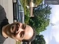
In front of the house on Johnathan Rd @40.5938,-74.3628

The view down the road @40.5938,-74.3628

