Difference between revisions of "2014-07-04 44 -121"
From Geohashing
imported>Frogman (→Achievements) |
imported>FippeBot m (Location) |
||
| Line 48: | Line 48: | ||
[[Category:Expeditions with photos]] | [[Category:Expeditions with photos]] | ||
[[Category:Coordinates reached]] | [[Category:Coordinates reached]] | ||
| + | {{location|US|OR|DE}} | ||
Latest revision as of 00:37, 15 August 2019
| Fri 4 Jul 2014 in 44,-121: 44.3268854, -121.6213256 geohashing.info google osm bing/os kml crox |
Location
A couple kilometers off of Highway 20 in Deschutes National Forest.
Participants
Plans
Expedition
I was on the way over to the Sunriver area and saw that this was pretty accessible. I was pleased to see that the nearby National Forest road was open to the public, so I was able to park about 400 meters away from the hashpoint. From there it was a fairly straightforward trek!
Tracklog
Photos
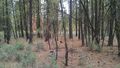
The hashpoint.

Our grins!

