Difference between revisions of "2014-07-04 49 8"
imported>DODO (→Tracklog) |
imported>FippeBot m (Location) |
||
| (2 intermediate revisions by one other user not shown) | |||
| Line 45: | Line 45: | ||
--> | --> | ||
<gallery perrow="5"> | <gallery perrow="5"> | ||
| + | Image:2014-07-04 49 8-1.jpg | Came along some animals before Hockenheim | ||
| + | Image:2014-07-04 49 8-2.jpg | parked my bull near the hash | ||
| + | Image:2014-07-04 49 8-3.jpg | proof | ||
| + | Image:2014-07-04 49 8-5.jpg | obligatory | ||
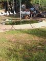
| + | Image:2014-07-04 49 8-4.jpg | view from the hash to the wild pigs wallow | ||
| + | Image:2014-07-04 49 8-7.jpg | the other way around, the hash is (around) 5m away | ||
| + | Image:2014-07-04 49 8-6.jpg | left a mark | ||
</gallery> | </gallery> | ||
| Line 50: | Line 57: | ||
{{#vardefine:ribbonwidth|800px}} | {{#vardefine:ribbonwidth|800px}} | ||
<!-- Add any achievement ribbons you earned below, or remove this section --> | <!-- Add any achievement ribbons you earned below, or remove this section --> | ||
| + | {{land geohash | ||
| + | |||
| + | | latitude = 49 | ||
| + | | longitude = 8 | ||
| + | | date = 2014-07-04 | ||
| + | | name = DODO | ||
| + | }} | ||
<!-- =============== USEFUL CATEGORIES FOLLOW ================ | <!-- =============== USEFUL CATEGORIES FOLLOW ================ | ||
Delete the next line ONLY if you have chosen the appropriate categories below. If you are unsure, don't worry. People will read your report and help you with the classification.--> | Delete the next line ONLY if you have chosen the appropriate categories below. If you are unsure, don't worry. People will read your report and help you with the classification.--> | ||
| − | |||
| − | |||
| − | |||
| − | |||
| − | |||
| − | |||
| − | |||
| − | |||
| − | |||
[[Category:Expeditions]] | [[Category:Expeditions]] | ||
| − | |||
[[Category:Expeditions with photos]] | [[Category:Expeditions with photos]] | ||
| − | |||
| − | |||
| − | |||
| − | |||
| − | |||
[[Category:Coordinates reached]] | [[Category:Coordinates reached]] | ||
| − | + | {{location|DE|BW|HD}} | |
| − | |||
| − | |||
| − | |||
| − | |||
| − | |||
| − | |||
| − | |||
| − | |||
| − | |||
| − | |||
| − | |||
| − | |||
| − | |||
| − | |||
| − | |||
| − | |||
| − | |||
Latest revision as of 00:37, 15 August 2019
| Fri 4 Jul 2014 in 49,8: 49.3268854, 8.6213256 geohashing.info google osm bing/os kml crox |
Location
In the forest between Hockenheim and Sandhausen next to the B291.
Participants
Plans
I haven't been hashing for almost three weeks and so I'd never forgive me not hunting for this one, which is just a 15 KM detour on my way to work. If no one else announces interest in a meetup, I'll go there on my way to work in the morning (around 8 am), but I'm also fine with going there on my way home.
Expedition
Quite an easy one. Got near the hash on my bull on the way to work, making a 15 KM detour. The weather - at least in the morning - was great. It wasn't to hot in the morning, but all the flavours filled the air already. The warm grain smelled sweet, I came through some forest and it was fresh, and when I crossed a clearing, the warm honeylike smell of the sandy heathland. All the way through the forest was bright light, but when I came near the hash, just this part of the forest was very dense and only some small paths lead through it. Of course accuracy went down in the dense wood, so I had to do some hashdancing, but it was pretty easy as the hash was on a small clearing in a wild pigs wallow (we had dry weather hear the last weeks so the wallow wasn't muddy). Took some pictures, constructed a mark and continued my ride to work.
Tracklog
Photos
Came along some animals before Hockenheim
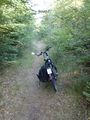
parked my bull near the hash
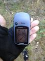
proof
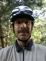
obligatory
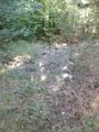
view from the hash to the wild pigs wallow
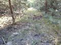
the other way around, the hash is (around) 5m away
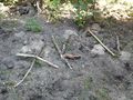
left a mark


Achievements
DODO earned the Land geohash achievement
|