Difference between revisions of "2014-07-06 50 9"
imported>GeorgDerReisende (new expedition) |
imported>FippeBot m (Location) |
||
| (2 intermediate revisions by one other user not shown) | |||
| Line 1: | Line 1: | ||
| − | |||
| − | |||
| − | |||
| − | |||
| − | |||
| − | |||
| − | |||
| − | |||
| − | |||
| − | |||
{{meetup graticule | {{meetup graticule | ||
| lat=50 | | lat=50 | ||
| Line 18: | Line 8: | ||
__NOTOC__ | __NOTOC__ | ||
== Location == | == Location == | ||
| − | + | ||
| + | The hash lies on a field near Dipperz. | ||
== Participants == | == Participants == | ||
| − | + | ||
| − | + | [[User:GeorgDerReisende|GeorgDerReisende]] | |
== Plans == | == Plans == | ||
| − | + | ||
| + | Hashiversary! Today it's a year of the day of my first geohashing expedition. I have to go. This seems the only reachable geohash nearby. But as hitchhiking to the south is always difficult, today I will try a new sign, only indicating that I will take the A7 to the south. | ||
== Expedition == | == Expedition == | ||
| − | |||
| − | + | I left home at 10 o'clock, started to hitchhike at 10:45 and got a lift after ten minutes with the new sign. I arrived at the junction Fulda-Mitte at 11:55. From there I walked to the hash. At first along the national road, then along field ways. I arrived at the hash at 12:50. It was an easy hash, no dance. Then I walked to the village and there I started to hitchhike home at 13:00, I got a lift after 30 minutes and arrived at Fulda at 13:45. Then I found a good looking place for hitchhiking. There I waited three hours for a lift, but nobody stopped. Then I walked to the motorway and I found out, that the junction had been closed for roadworks during the day. From there I needed two hours to arrive at the junction Wilhelmshöhe. I arrived at home at 20:15. | |
| − | |||
== Photos == | == Photos == | ||
| Line 38: | Line 28: | ||
--> | --> | ||
<gallery perrow="5"> | <gallery perrow="5"> | ||
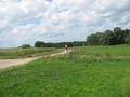
| + | Image:2014-07-06 50 9 GeorgDerReisende 2822.jpg | 4.2 km to hash, where is the footpath? | ||
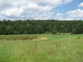
| + | Image:2014-07-06 50 9 GeorgDerReisende 2838.jpg | hash is near | ||
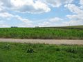
| + | Image:2014-07-06 50 9 GeorgDerReisende 2839.jpg | five meters to go | ||
| + | Image:2014-07-06 50 9 GeorgDerReisende 2840.jpg | proof | ||
| + | Image:2014-07-06 50 9 GeorgDerReisende 2843.jpg | the west | ||
| + | Image:2014-07-06 50 9 GeorgDerReisende 2845.jpg | the north | ||
| + | Image:2014-07-06 50 9 GeorgDerReisende 2846.jpg | the south | ||
| + | Image:2014-07-06 50 9 GeorgDerReisende 2847.jpg | the geohasher | ||
| + | Image:2014-07-06 50 9 GeorgDerReisende 2848.jpg | the east | ||
| + | Image:2014-07-06 50 9 GeorgDerReisende 2851.jpg | proof of no dance | ||
</gallery> | </gallery> | ||
| Line 44: | Line 44: | ||
<!-- Add any achievement ribbons you earned below, or remove this section --> | <!-- Add any achievement ribbons you earned below, or remove this section --> | ||
| + | {{ Hashiversary | new = 2014-07-06 50 9 | original = 2013-07-06 52 9 | ordinal = 1st | name = GeorgDerReisende | gender = his }} | ||
| − | + | [[Category:Expeditions]] | |
| − | |||
| − | [[Category: | ||
| − | + | [[Category:Expeditions with photos]] | |
| − | |||
| − | |||
| − | |||
| − | |||
| − | |||
| − | |||
| − | |||
| − | |||
| − | |||
| − | |||
| − | |||
| − | |||
| − | |||
| − | |||
[[Category:Coordinates reached]] | [[Category:Coordinates reached]] | ||
| − | + | {{location|DE|HE|FD}} | |
| − | |||
| − | |||
| − | |||
| − | |||
| − | |||
| − | |||
| − | |||
| − | |||
| − | |||
| − | |||
| − | |||
| − | |||
| − | |||
| − | |||
| − | |||
| − | |||
| − | |||
Latest revision as of 00:25, 7 August 2019
| Sun 6 Jul 2014 in 50,9: 50.5483119, 9.7884283 geohashing.info google osm bing/os kml crox |
Location
The hash lies on a field near Dipperz.
Participants
Plans
Hashiversary! Today it's a year of the day of my first geohashing expedition. I have to go. This seems the only reachable geohash nearby. But as hitchhiking to the south is always difficult, today I will try a new sign, only indicating that I will take the A7 to the south.
Expedition
I left home at 10 o'clock, started to hitchhike at 10:45 and got a lift after ten minutes with the new sign. I arrived at the junction Fulda-Mitte at 11:55. From there I walked to the hash. At first along the national road, then along field ways. I arrived at the hash at 12:50. It was an easy hash, no dance. Then I walked to the village and there I started to hitchhike home at 13:00, I got a lift after 30 minutes and arrived at Fulda at 13:45. Then I found a good looking place for hitchhiking. There I waited three hours for a lift, but nobody stopped. Then I walked to the motorway and I found out, that the junction had been closed for roadworks during the day. From there I needed two hours to arrive at the junction Wilhelmshöhe. I arrived at home at 20:15.
Photos
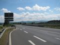
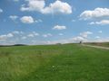
4.2 km to hash, where is the footpath?
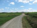
hash is near
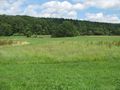
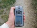
five meters to go
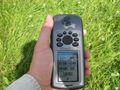
proof
the west
the north
the south
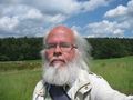
the geohasher
the east
proof of no dance


Achievements
GeorgDerReisende earned the 1st Hashiversary achievement
|