Difference between revisions of "2014-07-13 47 11"
imported>LeslieHapablap ([retro picture] Reached.) |
imported>LeslieHapablap (→Expedition) |
||
| Line 40: | Line 40: | ||
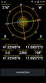
*Point reached! Visibility near zero :-) -- [[User:LeslieHapablap|LeslieHapablap]] ([[User talk:LeslieHapablap|talk]]) [http://www.openstreetmap.org/?lat=47.22359062&lon=11.59073251&zoom=16&layers=B000FTF @47.2236,11.5907] 03:51, 13 July 2014 (EDT) | *Point reached! Visibility near zero :-) -- [[User:LeslieHapablap|LeslieHapablap]] ([[User talk:LeslieHapablap|talk]]) [http://www.openstreetmap.org/?lat=47.22359062&lon=11.59073251&zoom=16&layers=B000FTF @47.2236,11.5907] 03:51, 13 July 2014 (EDT) | ||
| − | + | On Friday I was excited to see the hashpoint on a mountain summit for the first time (at least only a few meters below the summit according to the contour lines on the map), additionally it wasn't too far away from Innsbruck. The maps didn't indicate any hiking paths leading directly to the summit (that has [https://www.openstreetmap.org/changeset/24149379 changed now]), so it wasn't quite clear if the point would be accessible. But some pictures I found of the summit showed a gentle profile, so we estimated the chances to reach the point as quite high, which turned out to be true. | |
| + | |||
== Photos == | == Photos == | ||
<!-- Insert pictures between the gallery tags using the following format: | <!-- Insert pictures between the gallery tags using the following format: | ||
Revision as of 21:34, 14 July 2014
| Sun 13 Jul 2014 in 47,11: 47.2236532, 11.5907277 geohashing.info google osm bing/os kml crox |

Location
The Roßkopf summit (30 m from the peak).
Participants
Plans
We had several points in the mountains already, but that a hashpoint lies directly on a summit has not happened before. If the weather permits, we will go for it. Update: The weather forecast is not great: some rain showers in the morning, chance of thunderstorms around noon and in the afternoon. Nevertheless we will go, planning to leave Innsbruck around 6.30 a.m. to be back in the valley before noon and avoid the thunderstorms (which can be quite dangerous in the mountains). The summit is at 2382 m (7814 ft), we are expecting around 3°C (37°F). The planned route is about 14 km and 1000 m difference in altitude.
Expedition
- Summit geohash! -- LeslieHapablap (talk) 10:59, 11 July 2014 (EDT)
- Point reached! Visibility near zero :-) -- LeslieHapablap (talk) @47.2236,11.5907 03:51, 13 July 2014 (EDT)
On Friday I was excited to see the hashpoint on a mountain summit for the first time (at least only a few meters below the summit according to the contour lines on the map), additionally it wasn't too far away from Innsbruck. The maps didn't indicate any hiking paths leading directly to the summit (that has changed now), so it wasn't quite clear if the point would be accessible. But some pictures I found of the summit showed a gentle profile, so we estimated the chances to reach the point as quite high, which turned out to be true.
Photos
Reached.
