Difference between revisions of "2014-07-17 49 8"
From Geohashing
imported>Q-Owl m |
imported>FippeBot m (Location) |
||
| (4 intermediate revisions by one other user not shown) | |||
| Line 8: | Line 8: | ||
And DON'T FORGET to add your expedition and the best photo you took to the gallery on the Main Page! We'd love to read your report, but that means we first have to discover it! :) | And DON'T FORGET to add your expedition and the best photo you took to the gallery on the Main Page! We'd love to read your report, but that means we first have to discover it! :) | ||
--> | --> | ||
| − | + | [[Image:2014-07-17 49 8 west.jpg|thumb|left]] | |
{{meetup graticule | {{meetup graticule | ||
| lat=49 | | lat=49 | ||
| Line 25: | Line 25: | ||
== Plan == | == Plan == | ||
| − | Drive by car to [[wikipedia:Lorsch|Lorsch]] and then by | + | Drive by car to [[wikipedia:Lorsch|Lorsch]] and then by bicycle to the hashpoint. |
== Expedition == | == Expedition == | ||
| + | |||
| + | I had a little bit of time and drove by car to Lorsch. For the next two kilometers I used my bicycle. | ||
| + | A short GPS dance showed the exact coordinates which I marked with 4 sticks. | ||
| − | |||
| − | + | And I had been here before (Déjà vu): The cache finals of GC42PEC and GC42NB1 had been here near the crossroad. They are archieved since 2013-11-30. | |
| − | + | ||
| − | + | I took some photos, | |
| − | found the cache [http:// | + | drove back to the car, logged two munzees in Lorsch, "found" the cache [http://www.opencaching.de/viewcache.php?wp=OC0054 OC0054] and drove home. :-) |
== Photos == | == Photos == | ||
| Line 40: | Line 42: | ||
Image:2014-##-## ## ## Alpha.jpg | Witty Comment | Image:2014-##-## ## ## Alpha.jpg | Witty Comment | ||
--> | --> | ||
| − | |||
| − | |||
<gallery perrow="5" > | <gallery perrow="5" > | ||
| − | Image:2014- | + | Image:2014-07-17 49 8 proof.png | Proof screenshot |
| − | Image:2014- | + | Image:2014-07-17 49 8 east.jpg | East |
| − | Image:2014- | + | Image:2014-07-17 49 8 west.jpg | West |
| − | Image:2014- | + | Image:2014-07-17 49 8 ne.jpg | Northeast |
| − | Image:2014- | + | Image:2014-07-17 49 8 sw.jpg | Southwest |
| − | Image:2014- | + | Image:2014-07-17 49 8 marked.jpg | HP marked |
| − | Image:2014- | + | Image:2014-07-17 49 8 found.jpg | found nearby |
| + | Image:2014-07-17 49 8 grin.jpg | Grin | ||
</gallery> | </gallery> | ||
| − | |||
<!-- | <!-- | ||
List of uploaded Files: | List of uploaded Files: | ||
| Line 60: | Line 60: | ||
== Achievements / Honorable Mention == | == Achievements / Honorable Mention == | ||
| − | {{#vardefine:ribbonwidth| | + | {{#vardefine:ribbonwidth|600px}} |
| + | {{Déjà vu geohash | ||
| + | | latitude = 49 | ||
| + | | longitude = 8 | ||
| + | | date = 2014-07-17 | ||
| + | | olddate = 2012-12-11 | ||
| + | | name = Q-Owl | ||
| + | }} | ||
{{land geohash | {{land geohash | ||
| − | | latitude = 49 | + | | latitude = 49 |
| − | | longitude = 8 | + | | longitude = 8 |
| − | | date = 2014- | + | | date = 2014-07-17 |
| − | | name = Q-Owl | + | | name = Q-Owl |
}} | }} | ||
{{bicycle geohash | {{bicycle geohash | ||
| − | + | | latitude = 49 | |
| − | + | | longitude = 8 | |
| − | + | | date = 2014-07-17 | |
| − | + | | name = Q-Owl | |
| − | + | | distance = 4 km | |
| − | + | | bothways = true | |
| − | + | | image = 2014-07-17 49 8 east.jpg | |
| − | |||
| − | |||
}} <!-- | }} <!-- | ||
{{Hash collision | {{Hash collision | ||
| Line 102: | Line 107: | ||
[[Category: Meetup on 2014-06-27]] | [[Category: Meetup on 2014-06-27]] | ||
[[Category: Meetup in 49 8]]--> | [[Category: Meetup in 49 8]]--> | ||
| + | {{location|DE|HE|HP}} | ||
Latest revision as of 00:46, 15 August 2019

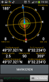
| Thu 17 Jul 2014 in 49,8: 49.6220248, 8.5372354 geohashing.info google osm bing/os kml crox |
Location
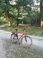
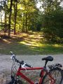
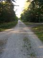
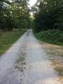
In the wood between Lorsch and Neuschloss on a forest aisle.
Participants
Plan
Drive by car to Lorsch and then by bicycle to the hashpoint.
Expedition
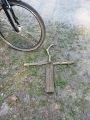
I had a little bit of time and drove by car to Lorsch. For the next two kilometers I used my bicycle. A short GPS dance showed the exact coordinates which I marked with 4 sticks.
And I had been here before (Déjà vu): The cache finals of GC42PEC and GC42NB1 had been here near the crossroad. They are archieved since 2013-11-30.
I took some photos, drove back to the car, logged two munzees in Lorsch, "found" the cache OC0054 and drove home. :-)
Photos
Proof screenshot
East
West
Northeast
Southwest
HP marked
found nearby

Grin


Achievements / Honorable Mention
Q-Owl earned the Déjà Vu Geohash Achievement
|
Q-Owl earned the Land geohash achievement
|
Q-Owl earned the Bicycle geohash achievement
|