Difference between revisions of "2014-07-17 49 8"
From Geohashing
imported>Q-Owl |
imported>FippeBot m (Location) |
||
| (2 intermediate revisions by one other user not shown) | |||
| Line 25: | Line 25: | ||
== Plan == | == Plan == | ||
| − | Drive by car to [[wikipedia:Lorsch|Lorsch]] and then by | + | Drive by car to [[wikipedia:Lorsch|Lorsch]] and then by bicycle to the hashpoint. |
== Expedition == | == Expedition == | ||
| − | I had a little bit of time and drove by car to Lorsch. For the next two kilometers I used my | + | I had a little bit of time and drove by car to Lorsch. For the next two kilometers I used my bicycle. |
A short GPS dance showed the exact coordinates which I marked with 4 sticks. | A short GPS dance showed the exact coordinates which I marked with 4 sticks. | ||
| − | And I had been here before (Déjà vu): The cache finals of GC42PEC and GC42NB1 had been here near the crossroad. | + | |
| + | |||
| + | And I had been here before (Déjà vu): The cache finals of GC42PEC and GC42NB1 had been here near the crossroad. They are archieved since 2013-11-30. | ||
I took some photos, | I took some photos, | ||
| − | drove back to the car, logged two munzees | + | drove back to the car, logged two munzees in Lorsch, "found" the cache [http://www.opencaching.de/viewcache.php?wp=OC0054 OC0054] and drove home. :-) |
| − | |||
| − | "found" the cache [http:// | ||
== Photos == | == Photos == | ||
| Line 43: | Line 43: | ||
--> | --> | ||
<gallery perrow="5" > | <gallery perrow="5" > | ||
| + | Image:2014-07-17 49 8 proof.png | Proof screenshot | ||
| + | Image:2014-07-17 49 8 east.jpg | East | ||
Image:2014-07-17 49 8 west.jpg | West | Image:2014-07-17 49 8 west.jpg | West | ||
| + | Image:2014-07-17 49 8 ne.jpg | Northeast | ||
| + | Image:2014-07-17 49 8 sw.jpg | Southwest | ||
| + | Image:2014-07-17 49 8 marked.jpg | HP marked | ||
| + | Image:2014-07-17 49 8 found.jpg | found nearby | ||
| + | Image:2014-07-17 49 8 grin.jpg | Grin | ||
</gallery> | </gallery> | ||
| − | |||
| − | |||
| − | |||
| − | |||
| − | |||
| − | |||
| − | |||
| − | |||
| − | |||
| − | |||
| − | |||
| − | |||
<!-- | <!-- | ||
List of uploaded Files: | List of uploaded Files: | ||
| Line 65: | Line 60: | ||
== Achievements / Honorable Mention == | == Achievements / Honorable Mention == | ||
| − | {{#vardefine:ribbonwidth| | + | {{#vardefine:ribbonwidth|600px}} |
{{Déjà vu geohash | {{Déjà vu geohash | ||
| latitude = 49 | | latitude = 49 | ||
| longitude = 8 | | longitude = 8 | ||
| − | | date = 2014- | + | | date = 2014-07-17 |
| − | + | | olddate = 2012-12-11 | |
| − | + | | name = Q-Owl | |
}} | }} | ||
{{land geohash | {{land geohash | ||
| latitude = 49 | | latitude = 49 | ||
| longitude = 8 | | longitude = 8 | ||
| − | | date = 2014- | + | | date = 2014-07-17 |
| name = Q-Owl | | name = Q-Owl | ||
}} | }} | ||
{{bicycle geohash | {{bicycle geohash | ||
| − | + | | latitude = 49 | |
| − | + | | longitude = 8 | |
| − | + | | date = 2014-07-17 | |
| − | + | | name = Q-Owl | |
| − | + | | distance = 4 km | |
| − | + | | bothways = true | |
| − | + | | image = 2014-07-17 49 8 east.jpg | |
| − | |||
| − | |||
}} <!-- | }} <!-- | ||
{{Hash collision | {{Hash collision | ||
| Line 114: | Line 107: | ||
[[Category: Meetup on 2014-06-27]] | [[Category: Meetup on 2014-06-27]] | ||
[[Category: Meetup in 49 8]]--> | [[Category: Meetup in 49 8]]--> | ||
| + | {{location|DE|HE|HP}} | ||
Latest revision as of 00:46, 15 August 2019

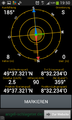
| Thu 17 Jul 2014 in 49,8: 49.6220248, 8.5372354 geohashing.info google osm bing/os kml crox |
Location
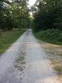
In the wood between Lorsch and Neuschloss on a forest aisle.
Participants
Plan
Drive by car to Lorsch and then by bicycle to the hashpoint.
Expedition
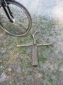
I had a little bit of time and drove by car to Lorsch. For the next two kilometers I used my bicycle. A short GPS dance showed the exact coordinates which I marked with 4 sticks.
And I had been here before (Déjà vu): The cache finals of GC42PEC and GC42NB1 had been here near the crossroad. They are archieved since 2013-11-30.
I took some photos, drove back to the car, logged two munzees in Lorsch, "found" the cache OC0054 and drove home. :-)
Photos
Proof screenshot
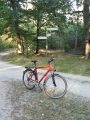
East
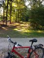
West
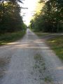
Northeast
Southwest
HP marked
found nearby

Grin


Achievements / Honorable Mention
Q-Owl earned the Déjà Vu Geohash Achievement
|
Q-Owl earned the Land geohash achievement
|
Q-Owl earned the Bicycle geohash achievement
|