Difference between revisions of "2014-07-23 32 -97"
imported>Michael5000 (→Location) |
imported>FippeBot m (Location) |
||
| (5 intermediate revisions by one other user not shown) | |||
| Line 25: | Line 25: | ||
*[[User:Michael5000|Michael5000]] | *[[User:Michael5000|Michael5000]] | ||
| − | == | + | == Expedition == |
| − | |||
| − | + | Having completed [[2014-07-23 33 -96]], I continued south to downtown Dallas, then took I-30 to downtown Fort Worth. I've never been in this part of the world before, and had always been interested to see what it was like for two cities to grow right into each other. I checked into a cheap motel not far from the Kimball Museum of Art -- I don't JUST drive long distances to stand in parking lots, you know -- and then took a fifteen mile out-and-back trip to this hashpoint. I got there just at sundown. As I was taking pictures, I was surprised by the arrival of a friendly horse. I think it was hoping for a horse treat, but instead it got to share the hashpoint with me, which was cool. | |
| − | + | ||
| + | Then, I headed back to the motel! I have three days to get to Denver, and it will be interesting to see if any more opportunities present themselves. With so much land on the plains in either cultivation or ranching, you just have to hope for the occasional coordinates that fall in a town or on a road. | ||
| − | |||
| − | |||
== Photos == | == Photos == | ||
| − | + | ||
| − | |||
| − | |||
<gallery perrow="5"> | <gallery perrow="5"> | ||
| + | File:2014-07-23 32 -97 camp.JPG|Base Camp Fort Worth | ||
| + | File:2014-07-23 32 -97 sunset.JPG|The sun sets as I approach the hashpoint | ||
| + | File:2014-07-23 32 -97 sign.JPG|View from the hashpoint | ||
| + | File:2014-07-23 32 -97 horse.JPG|The hashhorse | ||
| + | File:2014-07-23 32 -97 me.JPG|The hashhuman | ||
</gallery> | </gallery> | ||
== Achievements == | == Achievements == | ||
{{#vardefine:ribbonwidth|800px}} | {{#vardefine:ribbonwidth|800px}} | ||
| − | |||
| − | |||
| − | |||
| − | |||
| − | |||
| − | |||
| − | + | {{Multihash2 | count = 2 | date = 2014-07-23 | name = [[User:Michael5000|Michael5000]]}} | |
| − | + | *My first Expedition to the state of Texas. | |
| − | + | *My southernmost Expedition | |
| − | |||
| − | |||
| − | |||
[[Category:Expeditions]] | [[Category:Expeditions]] | ||
| − | |||
[[Category:Expeditions with photos]] | [[Category:Expeditions with photos]] | ||
| − | |||
| − | |||
| − | |||
| − | |||
| − | |||
[[Category:Coordinates reached]] | [[Category:Coordinates reached]] | ||
| − | + | {{location|US|TX|TN}} | |
| − | |||
| − | |||
| − | |||
| − | |||
| − | |||
| − | |||
| − | |||
| − | |||
| − | |||
| − | |||
| − | |||
| − | |||
| − | |||
| − | |||
| − | |||
| − | |||
| − | |||
Latest revision as of 00:26, 7 August 2019
| Wed 23 Jul 2014 in 32,-97: 32.9500150, -97.4115854 geohashing.info google osm bing/os kml crox |
Location
Just off Blue Mound Road, north of Saginaw.
Participants
Expedition
Having completed 2014-07-23 33 -96, I continued south to downtown Dallas, then took I-30 to downtown Fort Worth. I've never been in this part of the world before, and had always been interested to see what it was like for two cities to grow right into each other. I checked into a cheap motel not far from the Kimball Museum of Art -- I don't JUST drive long distances to stand in parking lots, you know -- and then took a fifteen mile out-and-back trip to this hashpoint. I got there just at sundown. As I was taking pictures, I was surprised by the arrival of a friendly horse. I think it was hoping for a horse treat, but instead it got to share the hashpoint with me, which was cool.
Then, I headed back to the motel! I have three days to get to Denver, and it will be interesting to see if any more opportunities present themselves. With so much land on the plains in either cultivation or ranching, you just have to hope for the occasional coordinates that fall in a town or on a road.
Photos
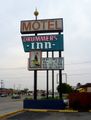
Base Camp Fort Worth
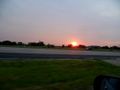
The sun sets as I approach the hashpoint
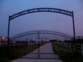
View from the hashpoint
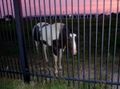
The hashhorse

The hashhuman


Achievements
Michael5000 earned the Multihash Achievement
|
- My first Expedition to the state of Texas.
- My southernmost Expedition