Difference between revisions of "2014-07-26 62 27"
imported>Mirca m |
m |
||
| (13 intermediate revisions by 3 users not shown) | |||
| Line 10: | Line 10: | ||
== Participants == | == Participants == | ||
| − | Mirca and her son | + | *[[User:Mirca|Mirca]] and her son |
== Plans == | == Plans == | ||
| − | It was fine and very warm weather and late in a lazy afternoon. We planned | + | It was fine and very warm weather and late in a lazy afternoon. We planned to first visit the hash point and then the local beach. |
== Expedition == | == Expedition == | ||
We drove 23 km southward along the motorway no. 5, turned westward to the road E63 and drove 5 km. Then we turned to the right to the road leading to Airaksela. Then about 7 km north, and a turn to the left to a narrow sand road named Rauhalantie. We drove about 250 m and we were near the point. The point was 2 meters from the road in the thicket consist of birches and short spruces with sharp needles. | We drove 23 km southward along the motorway no. 5, turned westward to the road E63 and drove 5 km. Then we turned to the right to the road leading to Airaksela. Then about 7 km north, and a turn to the left to a narrow sand road named Rauhalantie. We drove about 250 m and we were near the point. The point was 2 meters from the road in the thicket consist of birches and short spruces with sharp needles. | ||
| + | I think it was an easy point to reach; no water-filled ditches, no marching amidst milliards of mosquitos. | ||
Then we drove to the local beach and swimmed in the lake Iso-Lauas, enjoying the summer evening and holiday! | Then we drove to the local beach and swimmed in the lake Iso-Lauas, enjoying the summer evening and holiday! | ||
| + | == Photos == | ||
| + | <gallery perrow="5"> | ||
| + | Image:2017-07-26 62 27 Proof.png | Proof | ||
| + | Image:2014-07-26 62 27 The road to the point.jpg | The road to the point | ||
| + | Image:2014-07-26 62 27 View over the hash point.jpg | View over the hash point | ||
| − | + | </gallery> | |
| + | |||
| + | [[Category:Expeditions]] | ||
| + | [[Category:Expeditions with photos]] | ||
| + | |||
| + | [[Category:Coordinates reached]] | ||
| + | {{location|FI|15}} | ||
Latest revision as of 15:55, 18 March 2022
| Sat 26 Jul 2014 in 62,27: 62.7434847, 27.3978304 geohashing.info google osm bing/os kml crox |
Contents
Location
In Airaksela, 35 km southward from the centrum of Kuopio
Participants
- Mirca and her son
Plans
It was fine and very warm weather and late in a lazy afternoon. We planned to first visit the hash point and then the local beach.
Expedition
We drove 23 km southward along the motorway no. 5, turned westward to the road E63 and drove 5 km. Then we turned to the right to the road leading to Airaksela. Then about 7 km north, and a turn to the left to a narrow sand road named Rauhalantie. We drove about 250 m and we were near the point. The point was 2 meters from the road in the thicket consist of birches and short spruces with sharp needles. I think it was an easy point to reach; no water-filled ditches, no marching amidst milliards of mosquitos.
Then we drove to the local beach and swimmed in the lake Iso-Lauas, enjoying the summer evening and holiday!
Photos
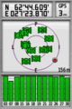
Proof
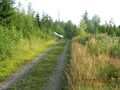
The road to the point
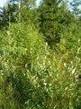
View over the hash point


