Difference between revisions of "2014-07-31 47 9"
imported>TFTD (Page created) |
imported>TFTD (Content) |
||
| Line 19: | Line 19: | ||
== Location == | == Location == | ||
<!-- where you've surveyed the hash to be --> | <!-- where you've surveyed the hash to be --> | ||
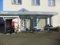
| + | The hash is right next to a house in Schlachters. | ||
== Participants == | == Participants == | ||
| − | + | [[User:TFTD | TFTD]] | |
| − | |||
== Plans == | == Plans == | ||
| − | + | As almost always I planned to go by bike. | |
== Expedition == | == Expedition == | ||
| − | + | It has been a while since I went geohashing and finally I saw that the coordinates for today are just a 15minuite bike ride from my current location so I couldn't say no. Especially with the nice weather and having 2 missed opportunities for geohashing in my mind. | |
| + | So overall nothing special happened. I got to know the area a little better and had a nice short bike ride in the sun after some rainy days. So went to the hast, took a picture and on my way back I took some more pictures because I had some nice views down to the Bodensee. And back at my starting point I was. Short, easy, enjoyable. | ||
| + | |||
== Tracklog == | == Tracklog == | ||
<!-- if your GPS device keeps a log, you may post a link here --> | <!-- if your GPS device keeps a log, you may post a link here --> | ||
| + | If anyone has a suggestion where to upload it permanently I can actually post one. | ||
== Photos == | == Photos == | ||
| Line 38: | Line 41: | ||
--> | --> | ||
<gallery perrow="5"> | <gallery perrow="5"> | ||
| + | Image:2014-07-31 01.jpg | Coordinate Proof. | ||
| + | Image:2014-07-31 02.jpg | Picture of the hash with my (new) bike. My old one still exists tho. Just not with me right now. | ||
| + | Image:2014-07-31 03.jpg | The Pfänder. | ||
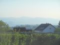
| + | Image:2014-07-31 04.jpg | Bregenz (Austria), Bodensee (East End) and Staufenspitze. | ||
| + | Image:2014-07-31 05.jpg | Lindau in the front. The thing in the middle of the Bodensee is the Rhein river. In the back you see Switzerland. | ||
| + | Image:2014-07-31 06.jpg | As always on my last geohashing adventures I just have to come across the Camino de Santiago de Compostela. | ||
</gallery> | </gallery> | ||
| Line 51: | Line 60: | ||
<!-- ==REQUEST FOR TWITTER BOT== Please leave either the New report or the Expedition planning category in as long as you work on it. This helps the twitter bot a lot with announcing the right outcome at the right moment. --> | <!-- ==REQUEST FOR TWITTER BOT== Please leave either the New report or the Expedition planning category in as long as you work on it. This helps the twitter bot a lot with announcing the right outcome at the right moment. --> | ||
| − | |||
| − | |||
| − | |||
| − | |||
| − | |||
| − | |||
[[Category:Expeditions]] | [[Category:Expeditions]] | ||
| − | + | [[Category:Expeditions with photos]] | |
| − | [[Category:Expeditions with photos]] | ||
| − | |||
| − | |||
| − | |||
| − | |||
| − | |||
[[Category:Coordinates reached]] | [[Category:Coordinates reached]] | ||
| − | + | [[Category: Meetup on 2014-07-31]] | |
| − | + | [[Category: Meetup in 47 09]] | |
| − | |||
| − | |||
| − | |||
| − | |||
| − | |||
| − | |||
| − | |||
| − | [[Category: | ||
| − | |||
| − | |||
| − | |||
| − | |||
| − | |||
| − | [[Category: | ||
| − | |||
| − | |||
Revision as of 20:34, 31 July 2014
| Thu 31 Jul 2014 in 47,09: 47.5878553, 09.7456345 geohashing.info google osm bing/os kml crox |
Location
The hash is right next to a house in Schlachters.
Participants
Plans
As almost always I planned to go by bike.
Expedition
It has been a while since I went geohashing and finally I saw that the coordinates for today are just a 15minuite bike ride from my current location so I couldn't say no. Especially with the nice weather and having 2 missed opportunities for geohashing in my mind. So overall nothing special happened. I got to know the area a little better and had a nice short bike ride in the sun after some rainy days. So went to the hast, took a picture and on my way back I took some more pictures because I had some nice views down to the Bodensee. And back at my starting point I was. Short, easy, enjoyable.
Tracklog
If anyone has a suggestion where to upload it permanently I can actually post one.
Photos
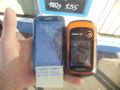
Coordinate Proof.
Picture of the hash with my (new) bike. My old one still exists tho. Just not with me right now.
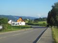
The Pfänder.
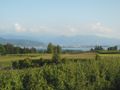
Bregenz (Austria), Bodensee (East End) and Staufenspitze.
Lindau in the front. The thing in the middle of the Bodensee is the Rhein river. In the back you see Switzerland.
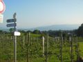
As always on my last geohashing adventures I just have to come across the Camino de Santiago de Compostela.


