Difference between revisions of "2014-08-02 59 23"
From Geohashing
imported>Bysmyyr |
imported>Tilley |
||
| Line 34: | Line 34: | ||
== Tracklog == | == Tracklog == | ||
<!-- if your GPS device keeps a log, you may post a link here --> | <!-- if your GPS device keeps a log, you may post a link here --> | ||
| − | See starting hash... | + | See [[2014-08-02_59_24 | starting hash...]] |
== Photos == | == Photos == | ||
| Line 50: | Line 50: | ||
{{#vardefine:ribbonwidth|800px}} | {{#vardefine:ribbonwidth|800px}} | ||
<!-- Add any achievement ribbons you earned below, or remove this section --> | <!-- Add any achievement ribbons you earned below, or remove this section --> | ||
| + | |||
| + | {{air geohash | latitude = 59 | longitude = 23 | date = 2014-08-02 | name = Bysmyyr | vehicle = Ultralight plane | subcategory = Pilot }} | ||
Revision as of 19:04, 3 August 2014
| Sat 2 Aug 2014 in 59,23: 59.9228439, 23.4103215 geohashing.info google osm bing/os kml crox |
Location
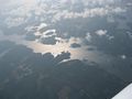
A forest near the sea.
Participants
Plans
Continue multihashing started from 2014-08-02_59_24
Expedition
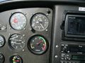
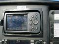
We got this one on high, about 7400 feet(~2,25km from the sea level). Then to next one: 2014-08-02_59_22
Tracklog
See starting hash...
Photos
Up
Proof
The hash


Achievements
Bysmyyr earned the Air geohash achievement
|