Difference between revisions of "2014-08-02 62 27"
From Geohashing
imported>Mirca |
imported>FippeBot m (Location) |
||
| (14 intermediate revisions by 3 users not shown) | |||
| Line 1: | Line 1: | ||
| − | |||
| − | |||
| − | |||
| − | |||
| − | |||
| − | |||
| − | |||
| − | |||
| − | |||
{{meetup graticule | {{meetup graticule | ||
| lat=62 | | lat=62 | ||
| Line 15: | Line 6: | ||
}} | }} | ||
| − | + | ||
__NOTOC__ | __NOTOC__ | ||
== Location == | == Location == | ||
| − | + | 25 km westward from the town of Kuopio near the village of Kaislastenlahti. About 10 meters from the road 5550. | |
== Participants == | == Participants == | ||
| − | Mirca and her son. | + | * [[User:Mirca|Mirca]] and |
| − | + | * her son. | |
== Plans == | == Plans == | ||
| − | We thought it could be great to find the hash point and after that visit the beach | + | We thought it could be great to find the hash point and after that visit the beach of the village |
== Expedition == | == Expedition == | ||
| − | We drove to Kaislastenlahti and after passing the village found the point was near. We left the car on the side of the crossing road named Käränkäniementie (what a stunning name :)) Then a brisk walk 100 meters backwards and to the bushes from the road. We went about 10 meters through the birch and rowan bushes and willowherbs. The point was under a willowherb | + | We drove to Kaislastenlahti and after passing the village found the point was near. We left the car on the side of the crossing road named Käränkäniementie (what a stunning name :)) Then a brisk walk 100 meters backwards and to the bushes from the road. We went about 10 meters through the birch and rowan bushes and willowherbs. The point was under a willowherb. |
| − | |||
| + | Then we drove to the beach and swam off all sweat. | ||
== Photos == | == Photos == | ||
| − | |||
| − | |||
| − | |||
<gallery perrow="5"> | <gallery perrow="5"> | ||
| + | Image:2014-08-02 62 27 The road towards the point.jpg | The road towards the point | ||
| + | Image:2014-08-02 62 27 To the bushes.JPG | To the bushes | ||
| + | Image:2014-08-02 62 27 The hash point with the willowherbs.JPG | The hash point with the willowherbs | ||
| + | Image:2014-08-02 62 27 Proof.png | Proof | ||
| + | Image:2014-02-08 62 27 Made for swimming.JPG | Made for swimming | ||
| + | |||
</gallery> | </gallery> | ||
== Achievements == | == Achievements == | ||
{{#vardefine:ribbonwidth|800px}} | {{#vardefine:ribbonwidth|800px}} | ||
| − | |||
| − | |||
| − | + | * Land Geohash | |
| − | |||
| − | |||
| − | |||
| − | |||
| − | |||
| − | |||
| − | |||
| − | |||
[[Category:Expeditions]] | [[Category:Expeditions]] | ||
| − | |||
[[Category:Expeditions with photos]] | [[Category:Expeditions with photos]] | ||
| − | |||
| − | |||
| − | |||
| − | |||
| − | |||
[[Category:Coordinates reached]] | [[Category:Coordinates reached]] | ||
| − | + | {{location|FI|15}} | |
| − | |||
| − | |||
| − | |||
| − | |||
| − | |||
| − | |||
| − | |||
| − | |||
| − | |||
| − | |||
| − | |||
| − | |||
| − | |||
| − | |||
| − | |||
| − | |||
| − | |||
Latest revision as of 00:56, 15 August 2019
| Sat 2 Aug 2014 in 62,27: 62.9228439, 27.4103215 geohashing.info google osm bing/os kml crox |
Location
25 km westward from the town of Kuopio near the village of Kaislastenlahti. About 10 meters from the road 5550.
Participants
- Mirca and
- her son.
Plans
We thought it could be great to find the hash point and after that visit the beach of the village
Expedition
We drove to Kaislastenlahti and after passing the village found the point was near. We left the car on the side of the crossing road named Käränkäniementie (what a stunning name :)) Then a brisk walk 100 meters backwards and to the bushes from the road. We went about 10 meters through the birch and rowan bushes and willowherbs. The point was under a willowherb.
Then we drove to the beach and swam off all sweat.
Photos
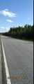
The road towards the point
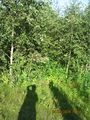
To the bushes
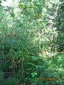
The hash point with the willowherbs
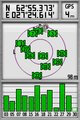
Proof
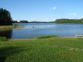
Made for swimming


Achievements
- Land Geohash