Difference between revisions of "2014-08-08 42 -78"
imported>Pedalpusher |
imported>Pedalpusher (→Gallery) |
||
| Line 23: | Line 23: | ||
== Gallery == | == Gallery == | ||
| − | + | <gallery perrow="4"> | |
| + | Image:2014-08-08_42_-78_directions.jpeg|My directions to get there and to my next destination. | ||
| + | Image:2014-08-08_42_-78_endpt_map.jpeg|A better view of the hash itself and how I planned to reach it. | ||
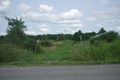
| + | Image:2014-08-08_42_-78_golf-course.JPeG|The Golf course...The hash should be just up the road... | ||
| + | Image:2014-08-08_42_-78_house-with-tower.JPEG|There's the house with the Radio tower! | ||
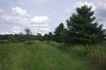
| + | Image:2014-08-08_42_-78_path.JPEG|...And the path, just like in the satellite picture. | ||
| + | Image:2014-08-08_42_-78_two-trees.JPEG|The hash is North of that second tree. | ||
| + | Image:2014-08-08_42_-78_hash.JPeG|tall grass at the hash. | ||
| + | Image:2014-08-08_42_-78_hash-me.JPEG|I made it! | ||
| + | </gallery> | ||
== Ribbons == | == Ribbons == | ||
Revision as of 22:19, 9 August 2014
| Fri 8 Aug 2014 in 42,-78: 42.5073857, -78.4311434 geohashing.info google osm bing/os kml crox |
Contents
Location
A bit South of the Town of Arcade, JUST South of Turkey Hill Golf course.
Participants
Expedition
No GPS so my map and directions to the site are all written out. Since I'm heading out to a Camp I worked at for an Alumni Reunion(and I'll be coming home late) I'm going to drive to my first Geohash. I'll head out after I finish up my half day of work.
Success! I got to the site around 14:40 without incident, passed the golf course, started counting driveways and Bam! There was the house with the radio tower. Everything looked the same as the Google satellite picture. There was the large path, the two large trees and the hash should be about 25 meters directly North of that second tree next to the path. I paced off 30(on open ground I can pace about a yard/meter). This being thick grass almost as tall as I was, I figured I wasn't getting full extensions. About 20 paces in I passed a matted down area where it looked like deer had bedded down recently. Upon thinking about it later I probably should have been on high alert for a raptor attack. As I wasn't thinking about it, I didn't take a picture to show the danger I was in. Since it was just me I got the standard pictures(will set up the gallery later) and left.
Things I got to see because of the Expedition
- a fox
- two American kestrel - small birds of prey
- an interesting looking hiking trail
Gallery
My directions to get there and to my next destination.
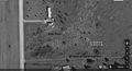
A better view of the hash itself and how I planned to reach it.
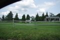
The Golf course...The hash should be just up the road...
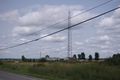
There's the house with the Radio tower!
...And the path, just like in the satellite picture.
The hash is North of that second tree.
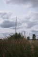
tall grass at the hash.
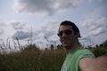
I made it!


Ribbons
Pedalpusher earned the Land geohash achievement
|
Pedalpusher earned the No Batteries Geohash Achievement
|