Difference between revisions of "2014-08-11 48 8"
From Geohashing
imported>Jiml m (Add some guesses at fields) |
imported>GeorgDerReisende m |
||
| Line 1: | Line 1: | ||
| − | |||
| − | |||
| − | |||
| − | |||
| − | |||
| − | |||
| − | |||
| − | |||
| − | |||
| − | |||
{{meetup graticule | {{meetup graticule | ||
| lat=48 | | lat=48 | ||
| Line 18: | Line 8: | ||
__NOTOC__ | __NOTOC__ | ||
== Location == | == Location == | ||
| − | East of Bad | + | East of Bad Dürrheim |
== Participants == | == Participants == | ||
| − | * [[User:RecentlyChanged]] | + | * [[User:RecentlyChanged|RecentlyChanged]] |
== Plans == | == Plans == | ||
Revision as of 20:18, 13 October 2014
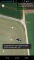
| Mon 11 Aug 2014 in 48,8: 48.0182065, 8.5566893 geohashing.info google osm bing/os kml crox |
Location
East of Bad Dürrheim
Participants
Plans
Expedition
Unknown.
Tracklog
http://www.everytrail.com/view_trip.php?trip_id=2918467 (Difficulties to upload, that's why it is two times the same path)
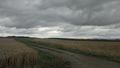
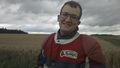
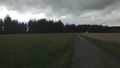
Photos
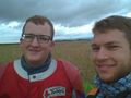
Proof :)
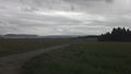
South
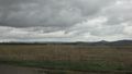
East
North-east
North-west
West


Achievements
- Land Geohash