Difference between revisions of "2014-08-23 52 -0"
imported>Tongs |
imported>FippeBot m (Location) |
||
| (4 intermediate revisions by one other user not shown) | |||
| Line 32: | Line 32: | ||
== Expedition == | == Expedition == | ||
| + | |||
| + | We had just completed [[2014-08-23 52 0|the other hashpoint]] in the doublehash. | ||
Arriving back in the car for the drive between the two points, we realised there was no mobile signal, and therefore no Google Maps to guide us. M did a great job of using the GPS receiver to guide F all 8km of the way to a road beside a field. We ventured into it and found the point within a minute, at around 16:50. Stopping to get evidence for a few minutes, we noticed a nearby wood. | Arriving back in the car for the drive between the two points, we realised there was no mobile signal, and therefore no Google Maps to guide us. M did a great job of using the GPS receiver to guide F all 8km of the way to a road beside a field. We ventured into it and found the point within a minute, at around 16:50. Stopping to get evidence for a few minutes, we noticed a nearby wood. | ||
| − | Everyone bounded off there, but found it was full of stingers. Instead we walked along a track for a while, and happened upon a rifle range, which looked like it had been dug into the hillside. We turned around and walked along a nice wooded path up a dried-out stream, back to the road and to the car. | + | Everyone bounded off there, but found it was full of stingers. Instead we walked along a track for a while, through beautiful sweeping hillside views which looked like the Windows background, and happened upon a rifle range, which looked like it had been dug into the hillside. We turned around and walked along a nice wooded path up a dried-out stream, back to the road and to the car. |
== Tracklog == | == Tracklog == | ||
| Line 43: | Line 45: | ||
== Photos == | == Photos == | ||
| − | (to | + | (more to come) |
<!-- Insert pictures between the gallery tags using the following format: | <!-- Insert pictures between the gallery tags using the following format: | ||
| Line 49: | Line 51: | ||
--> | --> | ||
<gallery perrow="5"> | <gallery perrow="5"> | ||
| + | Image:2014-08-23 52 -0 GPS.jpg | GPS readout at the hashpoint. | ||
</gallery> | </gallery> | ||
| Line 58: | Line 61: | ||
[[Category:Expeditions with photos]] | [[Category:Expeditions with photos]] | ||
[[Category:Coordinates reached]] | [[Category:Coordinates reached]] | ||
| + | {{location|GB|ENG|HRT}} | ||
Latest revision as of 01:07, 15 August 2019
| Sat 23 Aug 2014 in 52,-0: 52.0215872, -0.0584295 geohashing.info google osm bing/os kml crox |
Location
Just off a track by the side of a field near the village of Therfield.
Participants
Plans
We were aware of the doublehash, but didn't decide to go for it until we'd got to the hashpoint in the Cambridge graticule, just over the meridian.
Expedition
We had just completed the other hashpoint in the doublehash.
Arriving back in the car for the drive between the two points, we realised there was no mobile signal, and therefore no Google Maps to guide us. M did a great job of using the GPS receiver to guide F all 8km of the way to a road beside a field. We ventured into it and found the point within a minute, at around 16:50. Stopping to get evidence for a few minutes, we noticed a nearby wood.
Everyone bounded off there, but found it was full of stingers. Instead we walked along a track for a while, through beautiful sweeping hillside views which looked like the Windows background, and happened upon a rifle range, which looked like it had been dug into the hillside. We turned around and walked along a nice wooded path up a dried-out stream, back to the road and to the car.
Tracklog
(to appear)
Photos
(more to come)
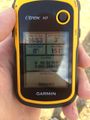
GPS readout at the hashpoint.
