Difference between revisions of "2014-08-23 52 0"
imported>Tongs |
imported>FippeBot m (Location) |
||
| (5 intermediate revisions by one other user not shown) | |||
| Line 33: | Line 33: | ||
We drove the 20km there, mostly along the main road, and turned off successively smaller roads until the GPS reported we were a couple of hundred metres from the hashpoint. We gingerly scampered up the hill and got there at 3.50pm, in time for the official 4pm meetup. Exploring a little more, we found a badger hole, lots of chalk, a mobile phone mast, and other stuff. We were in a relatively big field with nice views from the hillside. A thin slice of woodland surrounded a ditch on the other side of the road. | We drove the 20km there, mostly along the main road, and turned off successively smaller roads until the GPS reported we were a couple of hundred metres from the hashpoint. We gingerly scampered up the hill and got there at 3.50pm, in time for the official 4pm meetup. Exploring a little more, we found a badger hole, lots of chalk, a mobile phone mast, and other stuff. We were in a relatively big field with nice views from the hillside. A thin slice of woodland surrounded a ditch on the other side of the road. | ||
| − | We sat there for a bit eating crisps, Tunnock's | + | We sat there for a bit eating crisps, Tunnock's teacakes and sweets, and talked about the possibility of going to another hashpoint only 8km away. Three planes flew above us at the same time. We ran down the hill and into the car. |
| − | We headed towards [[2014-08-23 52 0|the other hashpoint]] in the doublehash. | + | We headed towards [[2014-08-23 52 -0|the other hashpoint]] in the doublehash. |
== Tracklog == | == Tracklog == | ||
| Line 44: | Line 44: | ||
== Photos == | == Photos == | ||
| − | (to | + | (more to come) |
<!-- Insert pictures between the gallery tags using the following format: | <!-- Insert pictures between the gallery tags using the following format: | ||
| Line 50: | Line 50: | ||
--> | --> | ||
<gallery perrow="5"> | <gallery perrow="5"> | ||
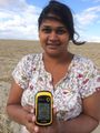
| + | Image:2014-08-23 52 0 GPS.jpg | M demonstrates proof of reaching the hashpoint. | ||
</gallery> | </gallery> | ||
| Line 62: | Line 63: | ||
[[Category:Expeditions with photos]] | [[Category:Expeditions with photos]] | ||
[[Category:Coordinates reached]] | [[Category:Coordinates reached]] | ||
| + | {{location|GB|ENG|CAM}} | ||
Latest revision as of 01:07, 15 August 2019
| Sat 23 Aug 2014 in 52,0: 52.0215872, 0.0584295 geohashing.info google osm bing/os kml crox |
Location
A field on a hillside near the village of Shaftenhoe End.
Participants
Plans
This expedition was planned out, and we even edited the wiki to reflect our intentions. We set off at about 3pm from central Cambridge with a huge box of snacks and an American football.
Expedition
We drove the 20km there, mostly along the main road, and turned off successively smaller roads until the GPS reported we were a couple of hundred metres from the hashpoint. We gingerly scampered up the hill and got there at 3.50pm, in time for the official 4pm meetup. Exploring a little more, we found a badger hole, lots of chalk, a mobile phone mast, and other stuff. We were in a relatively big field with nice views from the hillside. A thin slice of woodland surrounded a ditch on the other side of the road.
We sat there for a bit eating crisps, Tunnock's teacakes and sweets, and talked about the possibility of going to another hashpoint only 8km away. Three planes flew above us at the same time. We ran down the hill and into the car.
We headed towards the other hashpoint in the doublehash.
Tracklog
(to appear)
Photos
(more to come)
M demonstrates proof of reaching the hashpoint.

Achievements
(doublehash)