Difference between revisions of "2014-08-24 37 -122"
imported>Codae |
imported>FippeBot m (Location) |
||
| (One intermediate revision by one other user not shown) | |||
| Line 41: | Line 41: | ||
--> | --> | ||
<gallery perrow="5"> | <gallery perrow="5"> | ||
| + | Image:2014-08-24 37 -122 Proof.jpg | As close as I was able to document. | ||
| + | Image:2014-08-24 37 -122 Bound.jpg | Allegedly on the other side (southeast) of the hashpoint. Physically northwest of the previous picture. | ||
| + | Image:2014-08-24 37 -122 Flushed.jpg | How I looked after twenty minutes of trying to get a good shot, ready to buy some water. | ||
| + | Image:2014-08-24 37 -122 Hashpoint.jpg | The hashpoint is around here somewhere. | ||
</gallery> | </gallery> | ||
| Line 46: | Line 50: | ||
{{#vardefine:ribbonwidth|800px}} | {{#vardefine:ribbonwidth|800px}} | ||
<!-- Add any achievement ribbons you earned below, or remove this section --> | <!-- Add any achievement ribbons you earned below, or remove this section --> | ||
| − | + | {{Land geohash|latitude=37|longitude=-122|date=2014-08-24}} | |
| + | {{Public transport geohash|latitude=37|longitude=-122|date=2014-08-24}} | ||
<!-- =============== USEFUL CATEGORIES FOLLOW ================ | <!-- =============== USEFUL CATEGORIES FOLLOW ================ | ||
Delete the next line ONLY if you have chosen the appropriate categories below. If you are unsure, don't worry. People will read your report and help you with the classification.--> | Delete the next line ONLY if you have chosen the appropriate categories below. If you are unsure, don't worry. People will read your report and help you with the classification.--> | ||
| − | |||
<!-- ==REQUEST FOR TWITTER BOT== Please leave either the New report or the Expedition planning category in as long as you work on it. This helps the twitter bot a lot with announcing the right outcome at the right moment. --> | <!-- ==REQUEST FOR TWITTER BOT== Please leave either the New report or the Expedition planning category in as long as you work on it. This helps the twitter bot a lot with announcing the right outcome at the right moment. --> | ||
| − | |||
| − | |||
| − | |||
| − | |||
| − | |||
[[Category:Expeditions]] | [[Category:Expeditions]] | ||
| − | + | ||
[[Category:Expeditions with photos]] | [[Category:Expeditions with photos]] | ||
| − | + | ||
| − | |||
| − | |||
| − | |||
| − | |||
[[Category:Coordinates reached]] | [[Category:Coordinates reached]] | ||
| − | + | {{location|US|CA|AA}} | |
| − | |||
| − | |||
| − | |||
| − | |||
| − | |||
| − | |||
| − | |||
| − | |||
| − | |||
| − | |||
| − | |||
| − | |||
| − | |||
| − | |||
| − | |||
| − | |||
| − | |||
Latest revision as of 01:07, 15 August 2019
| Sun 24 Aug 2014 in 37,-122: 37.6193152, -122.0633142 geohashing.info google osm bing/os kml crox |
Location
By a fence in Hayward, California. It's not clear which side of the fence, though.
Participants
Plans
Get to Hayward by a combination of BART, bus, and walking, and hope that the hashpoint is on the street side of the fence rather than the house side. If the latter, walk around to the entrance of the neighborhood and try ambassading.
Expedition
I got to the geohash without incident (other than the discovery that the timetables I'd looked up had been the wrong ones) and found it to be in the vicinity of a gated-off driveway to a utility building. I deemed this a good thing, since without the ensuing alcove I wouldn't be able to get as far east.
Then came the GPS dance. My goal was to get to a point where my GPS would give the right location with milliminute precision. Thanks to the volatility of my readings, I was able to accomplish this (though not while my camera was at hand). I therefore decided to call the expedition a success, even though it seems that, if I had an accurate GPS, I could definitively establish the hashpoint as being inaccessible, either on or behind the fence. Because of this judgment and the extra walking an attack on the other side would entail, I made for home.
While waiting for the bus, I bought a bottle of water. I believe this was my first transaction undertaken entirely in Spanish.
Tracklog
Photos
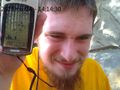
As close as I was able to document.
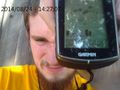
Allegedly on the other side (southeast) of the hashpoint. Physically northwest of the previous picture.
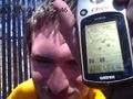
How I looked after twenty minutes of trying to get a good shot, ready to buy some water.
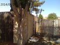
The hashpoint is around here somewhere.


Achievements
This user earned the Land geohash achievement
|
This user earned the Public transport geohash achievement
|