Difference between revisions of "2014-08-24 42 -79"
imported>Pedalpusher (Created page with "{{subst:Expedition |lat = 42 |lon = -79 |date = 2014-08-24 }}") |
imported>FippeBot m (Location) |
||
| (4 intermediate revisions by one other user not shown) | |||
| Line 1: | Line 1: | ||
| − | |||
| − | |||
| − | |||
| − | |||
| − | |||
| − | |||
| − | |||
| − | |||
| − | |||
| − | |||
{{meetup graticule | {{meetup graticule | ||
| lat=42 | | lat=42 | ||
| Line 18: | Line 8: | ||
__NOTOC__ | __NOTOC__ | ||
== Location == | == Location == | ||
| − | + | Near Evangola State Park off Rt 5 in a small forested area | |
== Participants == | == Participants == | ||
| − | + | [[User:Pedalpusher|Pedalpusher]] | |
| − | |||
| − | |||
| − | |||
| − | |||
== Expedition == | == Expedition == | ||
| − | < | + | This was a very close hash to the west of my home graticule and seeing as it was a beautiful day, I decided I was going to get a good ride in and get the Bicycle Ribbon as well. The expedition started around 14:00 and I headed out of town on one of the main roads. It turns out that they were working on re-surfacing the road so about 2 miles in, I got to deal with grooved pavement and heavy vibration. I now know a bit of what those guys racing in Europe on cobblestones feel like...<br><br> |
| − | + | 3 miles of shaking later, I'm still looking for my turn-off. Finally when I hit the end of the construction, of course that is where I find my turn and I'm happy to be on smooth ground again. Most of the rest of the ride out was uneventful but I did have a 30 second conversation with a driver when I got stuck at a light at Rt 5. Once I made my turn, I paused a moment to turn on my GPS as I knew the hash was just a few miles down the road. With 1.5 miles to go, I saw on the other side of the road 2 kids walking their bikes. I made a quick U-turn and asked if they had a flat. The one did and I offered my patch kit for use, but they had BMX style bikes so we needed a wrench to get the tire off. Fortunately, they were staying at the motel about 200 yards away so we walked back thinking he had some tools in his parents' car. Turns out the father didn't have tools and the tire-iron would have worked but the axle bolt stuck out too far to grab. He thanked me for my assistance and I wished him luck and was back on my way. <BR><br> | |
| − | + | Keeping an eye on my GPS, I found the patch of forest and saw that the edge along the road was pretty thick. I found a small opening and took my bike through and saw that no one in passing on the road would know anyone was in here. I leaned my bike against a tree and wandered toward the hash. It was thick in places but where I needed to get through, there just happened to be a path and always in the right direction! I got close, did the GPS dance and narrowed down the spot. I got my pictures and headed back to my bike where I rested for a bit and had some water. Ready to go, I got back on the road and headed for home.<br><br> | |
| − | + | Just up the road from the hash, I passed a heavy duty hook for trailers or chains or something and thought that was pretty cool. The road was clear so I executed a quick U-turn and grabbed it. It was heavy but it fit in my back pocket and I was off again. Later in a more wooded area, I got to see a Baltimore Oriole fly across the road in front of me. Shortly after that I passed a golf ball on the side of the road and again thought "neat!" stopping to pick that up too.<br><br> | |
| + | Finally, I got back to the dreaded grooved pavement and suffered for a while as my legs were vibrated to near numbness. I was relieved to get back to smooth pavement and made it back home. | ||
== Photos == | == Photos == | ||
| Line 38: | Line 25: | ||
--> | --> | ||
<gallery perrow="5"> | <gallery perrow="5"> | ||
| + | Image:2014-08-24 gps2.jpg|I'm close | ||
| + | Image:2014-08-24 gps1.jpg|Within the error | ||
| + | Image:2014-08-24_helmet-head.jpg|Showing off the ever popular Helmet Hair | ||
| + | Image:2014-08-24 bike.jpg|My bike | ||
| + | Image:2014-08-24 1-way-dist.jpg|Distance to the hash | ||
| + | Image:2014-08-24_great-finds.jpg|The awesome stuff I found | ||
| + | Image:2014-08-24 total-dist.jpg|Round trip distance | ||
</gallery> | </gallery> | ||
== Achievements == | == Achievements == | ||
{{#vardefine:ribbonwidth|800px}} | {{#vardefine:ribbonwidth|800px}} | ||
| − | + | {{land geohash | |
| − | + | | latitude = 42 | |
| − | + | | longitude = -79 | |
| − | + | | date = 2014-08-24 | |
| − | + | }} | |
| − | + | {{bicycle geohash | |
| − | + | | latitude = 42 | |
| − | + | | longitude = -79 | |
| − | + | | date = 2014-08-24 | |
| − | + | | name = Pedalpusher | |
| − | + | | distance = 32.64 Mi | |
| − | + | | bothways = true | |
| − | + | }} | |
| − | |||
[[Category:Expeditions]] | [[Category:Expeditions]] | ||
| − | |||
[[Category:Expeditions with photos]] | [[Category:Expeditions with photos]] | ||
| − | |||
| − | |||
| − | |||
| − | |||
| − | |||
[[Category:Coordinates reached]] | [[Category:Coordinates reached]] | ||
| − | + | {{location|US|NY|ER}} | |
| − | |||
| − | |||
| − | |||
| − | |||
| − | |||
| − | |||
| − | |||
| − | |||
| − | |||
| − | |||
| − | |||
| − | |||
| − | |||
| − | |||
| − | |||
| − | |||
| − | |||
Latest revision as of 01:08, 15 August 2019
| Sun 24 Aug 2014 in 42,-79: 42.6193152, -79.0633142 geohashing.info google osm bing/os kml crox |
Location
Near Evangola State Park off Rt 5 in a small forested area
Participants
Expedition
This was a very close hash to the west of my home graticule and seeing as it was a beautiful day, I decided I was going to get a good ride in and get the Bicycle Ribbon as well. The expedition started around 14:00 and I headed out of town on one of the main roads. It turns out that they were working on re-surfacing the road so about 2 miles in, I got to deal with grooved pavement and heavy vibration. I now know a bit of what those guys racing in Europe on cobblestones feel like...
3 miles of shaking later, I'm still looking for my turn-off. Finally when I hit the end of the construction, of course that is where I find my turn and I'm happy to be on smooth ground again. Most of the rest of the ride out was uneventful but I did have a 30 second conversation with a driver when I got stuck at a light at Rt 5. Once I made my turn, I paused a moment to turn on my GPS as I knew the hash was just a few miles down the road. With 1.5 miles to go, I saw on the other side of the road 2 kids walking their bikes. I made a quick U-turn and asked if they had a flat. The one did and I offered my patch kit for use, but they had BMX style bikes so we needed a wrench to get the tire off. Fortunately, they were staying at the motel about 200 yards away so we walked back thinking he had some tools in his parents' car. Turns out the father didn't have tools and the tire-iron would have worked but the axle bolt stuck out too far to grab. He thanked me for my assistance and I wished him luck and was back on my way.
Keeping an eye on my GPS, I found the patch of forest and saw that the edge along the road was pretty thick. I found a small opening and took my bike through and saw that no one in passing on the road would know anyone was in here. I leaned my bike against a tree and wandered toward the hash. It was thick in places but where I needed to get through, there just happened to be a path and always in the right direction! I got close, did the GPS dance and narrowed down the spot. I got my pictures and headed back to my bike where I rested for a bit and had some water. Ready to go, I got back on the road and headed for home.
Just up the road from the hash, I passed a heavy duty hook for trailers or chains or something and thought that was pretty cool. The road was clear so I executed a quick U-turn and grabbed it. It was heavy but it fit in my back pocket and I was off again. Later in a more wooded area, I got to see a Baltimore Oriole fly across the road in front of me. Shortly after that I passed a golf ball on the side of the road and again thought "neat!" stopping to pick that up too.
Finally, I got back to the dreaded grooved pavement and suffered for a while as my legs were vibrated to near numbness. I was relieved to get back to smooth pavement and made it back home.
Photos
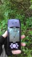
I'm close
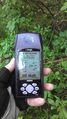
Within the error

Showing off the ever popular Helmet Hair
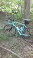
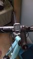
My bike
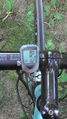
Distance to the hash
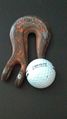
The awesome stuff I found
Round trip distance


Achievements
This user earned the Land geohash achievement
|
Pedalpusher earned the Bicycle geohash achievement
|