Difference between revisions of "2014-08-24 45 -123"
From Geohashing
imported>Michael5000 m |
imported>Michael5000 m |
||
| Line 1: | Line 1: | ||
| − | [[ | + | [[File:2014-08-24 45 -123 Tree|Hashtree|thumb|left]] |
{{meetup graticule | {{meetup graticule | ||
Revision as of 22:51, 24 August 2014
File:2014-08-24 45 -123 Tree
Hashtree
| Sun 24 Aug 2014 in 45,-123: 45.6193152, -123.0633142 geohashing.info google osm bing/os kml crox |
Location
On a rural road just north of the junction of U.S. 26 and Oregon Highway 6.
Participants
Expedition
After a long drought of accessible hashpoints in the region, the appearance of this one made my Sunday plans to me before I was fully out of bed on Friday morning. It was an easy matter to reach the hashpoint, under its delightful huge hashtree, and take a few photos. This set the stage for running on the nearby Banks-Vernonia Trail and a Sunday drive through the little towns of Yamhill County. Splendid.
Photos
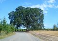
The lovely 2014-08-24 45 -123 hashtree!

View of the expedition vehicle and valley from under the tree.

