Difference between revisions of "2014-08-25 51 9"
From Geohashing
imported>GeorgDerReisende (create page) |
imported>GeorgDerReisende (expedition report added) |
||
| Line 1: | Line 1: | ||
| − | |||
| − | |||
| − | |||
| − | |||
| − | |||
| − | |||
| − | |||
| − | |||
| − | |||
| − | |||
{{meetup graticule | {{meetup graticule | ||
| lat=51 | | lat=51 | ||
| Line 18: | Line 8: | ||
__NOTOC__ | __NOTOC__ | ||
== Location == | == Location == | ||
| − | + | ||
| + | The hash lied in the street ''In der Laake'' in Lenglern. | ||
== Participants == | == Participants == | ||
| − | + | ||
| − | + | [[User:GeorgDerReisende|GeorgDerReisende]] | |
== Plans == | == Plans == | ||
| − | + | ||
| + | Hitchhiking and looking for the hash. | ||
== Expedition == | == Expedition == | ||
| − | |||
| − | + | The start of hitchhiking was easy, because I got a car within five minutes, and this car brought me directly to Lenglern. It was a quick walk to the hash and I found it on the access way to the house. I made a quick step to the hash and a quick step back to the street. For a moment I saw the 0 meter mark, but I didn't want to dance around there. | |
| − | |||
== Photos == | == Photos == | ||
| Line 38: | Line 28: | ||
--> | --> | ||
<gallery perrow="5"> | <gallery perrow="5"> | ||
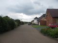
| + | Image:2014-08-25 51 9 GeorgDerReisende 4815.jpg | In der Laake | ||
| + | Image:2014-08-25 51 9 GeorgDerReisende 4816.jpg | You see the hash. | ||
| + | Image:2014-08-25 51 9 GeorgDerReisende 4817.jpg | Proof. | ||
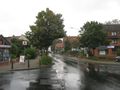
| + | Image:2014-08-25 51 9 GeorgDerReisende 4818.jpg | In der Laake, to the north. | ||
| + | Image:2014-08-25 51 9 GeorgDerReisende 4819.jpg | In der Laake, to the east. | ||
| + | Image:2014-08-25 51 9 GeorgDerReisende 4820.jpg | In der Laake, to the south. | ||
| + | Image:2014-08-25 51 9 GeorgDerReisende 4821.jpg | The geohasher. | ||
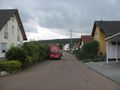
| + | Image:2014-08-25 51 9 GeorgDerReisende 4832.jpg | The main street of Lenglern. | ||
| + | Image:2014-08-25 51 9 GeorgDerReisende 4858.jpg | Lenglern from above. | ||
</gallery> | </gallery> | ||
| Line 44: | Line 43: | ||
<!-- Add any achievement ribbons you earned below, or remove this section --> | <!-- Add any achievement ribbons you earned below, or remove this section --> | ||
| + | {{Thumbs Up | latitude = 51 | longitude = 9 | date = 2014-08-25 | name = GeorgDerReisende }} | ||
| − | + | [[Category:Expeditions]] | |
| − | |||
| − | [[Category: | ||
| − | + | [[Category:Expeditions with photos]] | |
| − | |||
| − | |||
| − | |||
| − | |||
| − | |||
| − | |||
| − | |||
| − | |||
| − | |||
| − | |||
| − | |||
| − | |||
| − | |||
| − | |||
[[Category:Coordinates reached]] | [[Category:Coordinates reached]] | ||
| − | |||
| − | |||
| − | |||
| − | |||
| − | |||
| − | |||
| − | |||
| − | |||
| − | |||
| − | |||
| − | |||
| − | |||
| − | |||
| − | |||
| − | |||
| − | |||
| − | |||
| − | |||
Revision as of 18:15, 25 August 2014
| Mon 25 Aug 2014 in 51,9: 51.5870872, 9.8796883 geohashing.info google osm bing/os kml crox |
Location
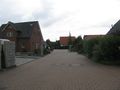
The hash lied in the street In der Laake in Lenglern.
Participants
Plans
Hitchhiking and looking for the hash.
Expedition
The start of hitchhiking was easy, because I got a car within five minutes, and this car brought me directly to Lenglern. It was a quick walk to the hash and I found it on the access way to the house. I made a quick step to the hash and a quick step back to the street. For a moment I saw the 0 meter mark, but I didn't want to dance around there.
Photos
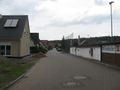
In der Laake
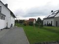
You see the hash.
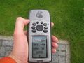
Proof.
In der Laake, to the north.
In der Laake, to the east.
In der Laake, to the south.
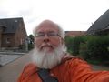
The geohasher.
The main street of Lenglern.
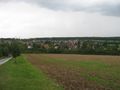
Lenglern from above.


Achievements
GeorgDerReisende earned the Thumbs Up Geohash Achievement
|