Difference between revisions of "2014-08-27 60 22"
imported>Suurnesu (View to north) |
imported>FippeBot m (Location) |
||
| (4 intermediate revisions by 2 users not shown) | |||
| Line 1: | Line 1: | ||
| − | |||
| − | |||
| − | |||
| − | |||
| − | |||
| − | |||
| − | |||
| − | |||
{{meetup graticule | {{meetup graticule | ||
| lat=60 | | lat=60 | ||
| Line 18: | Line 10: | ||
__NOTOC__ | __NOTOC__ | ||
== Location == | == Location == | ||
| − | + | Island of Ruissalo, Turku | |
== Participants == | == Participants == | ||
| − | + | [[User:Suurnesu|Suurnesu]] | |
| − | |||
| − | |||
| − | |||
| − | |||
== Expedition == | == Expedition == | ||
| − | + | I noticed that a hashpoint has again landed on one of my favorite spots in Turku, island of Ruissalo. It had been a rainy day but in the evening rained stopped. There was some time before the sunset, so I decided to visit the point before it gets too dark. | |
| − | + | I left my car at the Botanical Garden's parking lot and started walking. I had taken a look at topographic map of the location back at home I found out that there is a path leading quite close to hashpoint. Unfortunately, I chose the wrong path first. After finding out that I am heading to the wrong direction, I turned back and finally found a narrow path. At some point I had to leave the path and walk some thirty meters in the bushes. Terrain wasn't very easy and I had to walk around quite a bit to find the zero point. There are a lot of oaks n this region and some gust dropped some water from the leaves on me. | |
| − | + | After taking some pictures I tried to follow my footsteps back to the trail but somehow I managed to go 90 degrees to the wrong location. Bit more bushwhacking and I found a road which led me back to my car. | |
| − | |||
| − | |||
| − | |||
== Photos == | == Photos == | ||
| − | |||
| − | |||
| − | |||
<gallery perrow="5"> | <gallery perrow="5"> | ||
| Line 44: | Line 26: | ||
Image:2014-08-27_60_22_Suurnesu_1409161486021.jpg | View to north | Image:2014-08-27_60_22_Suurnesu_1409161486021.jpg | View to north | ||
| + | |||
| + | Image:2014-08-27_60_22_Suurnesu_1409161478454.jpg | View to south | ||
</gallery> | </gallery> | ||
| Line 51: | Line 35: | ||
| − | |||
| − | |||
| − | |||
| − | |||
| − | |||
| − | |||
| − | |||
| − | |||
| − | |||
| − | |||
| − | |||
| − | |||
[[Category:Expeditions]] | [[Category:Expeditions]] | ||
| − | + | [[Category:Expeditions with photos]] | |
| − | [[Category:Expeditions with photos]] | ||
| − | |||
| − | |||
| − | |||
| − | |||
| − | |||
[[Category:Coordinates reached]] | [[Category:Coordinates reached]] | ||
| − | + | {{location|FI|19}} | |
| − | |||
| − | |||
| − | |||
| − | |||
| − | |||
| − | |||
| − | |||
| − | |||
| − | |||
| − | |||
| − | |||
| − | |||
| − | |||
| − | |||
| − | |||
| − | |||
| − | |||
Latest revision as of 01:10, 15 August 2019
| Wed 27 Aug 2014 in 60,22: 60.4336937, 22.1677110 geohashing.info google osm bing/os kml crox |
Location
Island of Ruissalo, Turku
Participants
Expedition
I noticed that a hashpoint has again landed on one of my favorite spots in Turku, island of Ruissalo. It had been a rainy day but in the evening rained stopped. There was some time before the sunset, so I decided to visit the point before it gets too dark. I left my car at the Botanical Garden's parking lot and started walking. I had taken a look at topographic map of the location back at home I found out that there is a path leading quite close to hashpoint. Unfortunately, I chose the wrong path first. After finding out that I am heading to the wrong direction, I turned back and finally found a narrow path. At some point I had to leave the path and walk some thirty meters in the bushes. Terrain wasn't very easy and I had to walk around quite a bit to find the zero point. There are a lot of oaks n this region and some gust dropped some water from the leaves on me. After taking some pictures I tried to follow my footsteps back to the trail but somehow I managed to go 90 degrees to the wrong location. Bit more bushwhacking and I found a road which led me back to my car.
Photos
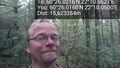
Selfie in Ruissalo
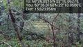
View to north
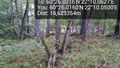
View to south


