Difference between revisions of "2014-09-03 39 -77"
imported>OfficeLinebacker ([live picture] Silly frown) |
m (per Renaming Proposal) |
||
| (8 intermediate revisions by 4 users not shown) | |||
| Line 20: | Line 20: | ||
<!-- where you've surveyed the hash to be --> | <!-- where you've surveyed the hash to be --> | ||
In a field in Bealsville, MD. A survey using Google Maps and Google Street View indicates it should be publicly accessible. | In a field in Bealsville, MD. A survey using Google Maps and Google Street View indicates it should be publicly accessible. | ||
| + | |||
| + | Upon arrival, I note that it is at the [http://www.montgomeryparks.org/parks_facilities_directory/woodstockequestriansp.shtm Woodstock Equestrian Park] | ||
== Participants == | == Participants == | ||
| Line 36: | Line 38: | ||
== Expedition == | == Expedition == | ||
<!-- how it all turned out. your narrative goes here. --> | <!-- how it all turned out. your narrative goes here. --> | ||
| + | The Satellite imagery indicated that the hashpoint was in a mowed area. Upon inspection, the area is now completely overgrown with waist-high vegetation, much of which has thorns. Being dressed in shorts and a tee shirt, and not feeling particularly hardcore, I retreated to the safety of my car and I can neither confirm nor deny that there were donuts and drifting performed in the completely empty gravel parking lot. | ||
| + | |||
| + | I ate lunch at Harris Teeter on the way home ($5 footlong Fridays all week this week) | ||
== Tracklog == | == Tracklog == | ||
| Line 51: | Line 56: | ||
Image:2014-09-03_39_-77_13-14-42-708.jpg | Silly frown | Image:2014-09-03_39_-77_13-14-42-708.jpg | Silly frown | ||
| + | |||
| + | Image:2014-09-03_39_-77_13-16-25-820.jpg | Closeup of one of the reasons I'm nature's bitch | ||
| + | |||
| + | Image:2014-09-03_39_-77_13-22-50-527.jpg | | ||
</gallery> | </gallery> | ||
| Line 56: | Line 65: | ||
{{#vardefine:ribbonwidth|800px}} | {{#vardefine:ribbonwidth|800px}} | ||
<!-- Add any achievement ribbons you earned below, or remove this section --> | <!-- Add any achievement ribbons you earned below, or remove this section --> | ||
| + | {{done with nature | ||
| + | | latitude = 39 | ||
| + | | longitude = -77 | ||
| + | | date = 2014-09-03 | ||
| + | | name = OfficeLinebacker | ||
| + | | image = 2014-09-03 39 -77 13-16-25-820.jpg | ||
| + | }} | ||
| − | |||
| − | |||
| − | |||
| − | |||
| − | |||
| − | |||
| − | |||
| − | |||
| − | |||
| − | |||
| − | |||
| − | |||
[[Category:Expeditions]] | [[Category:Expeditions]] | ||
| − | |||
[[Category:Expeditions with photos]] | [[Category:Expeditions with photos]] | ||
| − | |||
| − | |||
| − | |||
| − | |||
| − | |||
| − | |||
| − | |||
| − | |||
| − | |||
[[Category:Coordinates not reached]] | [[Category:Coordinates not reached]] | ||
| − | |||
| − | |||
[[Category:Not reached - Mother Nature]] | [[Category:Not reached - Mother Nature]] | ||
| − | + | {{location|US|MD|MO}} | |
| − | |||
| − | |||
| − | |||
| − | |||
| − | |||
| − | |||
| − | |||
| − | |||
| − | |||
| − | |||
Latest revision as of 14:31, 2 April 2024
| Wed 3 Sep 2014 in 39,-77: 39.1882829, -77.4246731 geohashing.info google osm bing/os kml crox |
Location
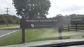
In a field in Bealsville, MD. A survey using Google Maps and Google Street View indicates it should be publicly accessible.
Upon arrival, I note that it is at the Woodstock Equestrian Park
Participants
OfficeLinebacker (talk)OfficeLinebacker
Plans
- Going to attempt this. -- OfficeLinebacker (talk) 12:19, 3 September 2014 (EDT)
Going to drive there, maybe get lunch in the area, and drive back.
Expedition
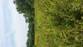
The Satellite imagery indicated that the hashpoint was in a mowed area. Upon inspection, the area is now completely overgrown with waist-high vegetation, much of which has thorns. Being dressed in shorts and a tee shirt, and not feeling particularly hardcore, I retreated to the safety of my car and I can neither confirm nor deny that there were donuts and drifting performed in the completely empty gravel parking lot.
I ate lunch at Harris Teeter on the way home ($5 footlong Fridays all week this week)
Tracklog
Photos
As close as I was willing to get, @39.1874,-77.4225

dressed like this @39.1875,-77.4224

Silly frown
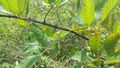
Closeup of one of the reasons I'm nature's bitch


Achievements
OfficeLinebacker earned the Done with Nature consolation prize
|