Difference between revisions of "2014-09-03 47 14"
imported>B2c ([live] Knittelfeld 2014-09-03) |
m (per Renaming Proposal) |
||
| (17 intermediate revisions by 4 users not shown) | |||
| Line 1: | Line 1: | ||
| − | |||
| − | |||
| − | |||
| − | |||
| − | |||
| − | |||
| − | |||
| − | |||
| − | |||
| − | |||
{{meetup graticule | {{meetup graticule | ||
| lat=47 | | lat=47 | ||
| Line 15: | Line 5: | ||
}} | }} | ||
| − | |||
| − | |||
== Location == | == Location == | ||
| − | + | [[Image:1 IMG_20140903_161504.jpg | thumb | left | In the woods in the middle of nowhere.]]Today's hash was located approximately 50km south of Waidhofen an der Ybbs, in the woods on a hill in the so called 'Gamsforst'. | |
| + | <br> | ||
| + | |||
== Participants == | == Participants == | ||
| − | + | * [[User:Patrizius|Patrizius]] | |
| − | + | * [[User:B2c|B2c]] | |
| + | <br> | ||
| + | |||
== Plans == | == Plans == | ||
| − | + | Although both patrizius and b2c had other plans for the day, they both had to reconsider because of the bad weather. So why not go for a quick hash? But, as we know, things sometimes escalate quickly. The hash fell in the upper-right most corner of the graticule, which allowed an (somewhat) easy grab of one of the last virgin graticules in Austria, the Knittelfeld graticule. So, why not go for it? | |
== Expedition == | == Expedition == | ||
| − | + | After a quick and somewhat improvised setup meeting, they grabbed some mountain gear (terrain maps screamed 'surprise!'), set up their GPS devices and began their journey. Although the weather was unsettled and there was lot's of traffic, they steadily made their way towards the hash, passing Krems, St. Pölten Waidhofen and Wieselburg on the way. The hashpoint was located somewhat afar from the state road L31, so they turned into a small, winding road and followed it for a couple of kilometres. When the hash appeared to be only a couple hundred meters away they parked the car, changed shoes and started to make their way up a hill. The rain was nice enough to take a break so they could spare the raincoats. They had to cross a wide meadow to reach the forrest in which it appeared the hash had taken refuge. But not for long! After a little bit of zig-zagging because of a dodgy GPS signal, they claimed one of Austria's last virgin graticules. Hooray! | |
| − | |||
== Tracklog == | == Tracklog == | ||
| − | + | [[File:Gps-2014-09-03-knittelfeld.png]] | |
| + | |||
== Photos == | == Photos == | ||
| − | < | + | <gallery caption="Photo Gallery" widths="320px" heights="213px" perrow="3"> |
| − | Image: | + | Image:1 IMG 20140903 155038.jpg | Our trusty hashcot. Too big to take to the hashpoint though. |
| − | + | Image:Snw 3.jpg | View backward, towards where we came from. | |
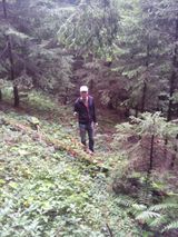
| − | + | Image:1 IMG 20140903 161008.jpg | patrizius checking the coordinates. | |
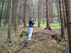
| + | Image:1 IMG 20140903 160215.jpg| GPS is a fickle beast sometimes. | ||
| + | Image:Snw 4.jpg | Pretty much there... | ||
| + | Image:Snw 1.jpg | At the hash. Stupid grin(tm). | ||
| + | Image:1 IMG 20140903 161504.jpg | The hashpoint from afar aka "Fairy woods bonus stage ;)". | ||
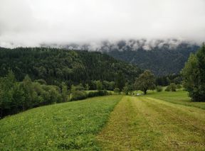
| + | Image:Snw 5.jpg | A nice view over the valley. | ||
| + | Image:Snw 2.png | Proof. | ||
| + | Image:2014-09-03 47 14 B2c 1409753369151.jpg | More proof. | ||
</gallery> | </gallery> | ||
| + | |||
== Achievements == | == Achievements == | ||
| − | {{ | + | {{Graticule unlocked |
| − | + | | latitude = 47 | longitude = 14 | date = 2014-09-03 | |
| − | + | | name = [[User:Patrizius|Patrizius]] | |
| − | + | }} | |
| − | + | {{Graticule unlocked | |
| − | + | | latitude = 47 | longitude = 14 | date = 2014-09-03 | |
| − | [[ | + | | name = [[User:B2c|B2c]] |
| + | }} | ||
| − | |||
| − | |||
| − | |||
| − | |||
| − | |||
| − | |||
[[Category:Expeditions]] | [[Category:Expeditions]] | ||
| − | |||
[[Category:Expeditions with photos]] | [[Category:Expeditions with photos]] | ||
| − | |||
| − | |||
| − | |||
| − | |||
| − | |||
[[Category:Coordinates reached]] | [[Category:Coordinates reached]] | ||
| − | + | {{location|AT|NÖ|AM}} | |
| − | |||
| − | |||
| − | |||
| − | |||
| − | |||
| − | |||
| − | |||
| − | |||
| − | |||
| − | |||
| − | |||
| − | |||
| − | |||
| − | |||
| − | |||
| − | |||
| − | |||
Latest revision as of 05:09, 20 March 2024
| Wed 3 Sep 2014 in 47,14: 47.8102777, 14.8670905 geohashing.info google osm bing/os kml crox |
Location

Today's hash was located approximately 50km south of Waidhofen an der Ybbs, in the woods on a hill in the so called 'Gamsforst'.
Participants
Plans
Although both patrizius and b2c had other plans for the day, they both had to reconsider because of the bad weather. So why not go for a quick hash? But, as we know, things sometimes escalate quickly. The hash fell in the upper-right most corner of the graticule, which allowed an (somewhat) easy grab of one of the last virgin graticules in Austria, the Knittelfeld graticule. So, why not go for it?
Expedition
After a quick and somewhat improvised setup meeting, they grabbed some mountain gear (terrain maps screamed 'surprise!'), set up their GPS devices and began their journey. Although the weather was unsettled and there was lot's of traffic, they steadily made their way towards the hash, passing Krems, St. Pölten Waidhofen and Wieselburg on the way. The hashpoint was located somewhat afar from the state road L31, so they turned into a small, winding road and followed it for a couple of kilometres. When the hash appeared to be only a couple hundred meters away they parked the car, changed shoes and started to make their way up a hill. The rain was nice enough to take a break so they could spare the raincoats. They had to cross a wide meadow to reach the forrest in which it appeared the hash had taken refuge. But not for long! After a little bit of zig-zagging because of a dodgy GPS signal, they claimed one of Austria's last virgin graticules. Hooray!
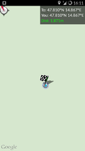
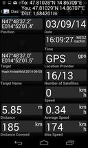
Tracklog

Photos
- Photo Gallery
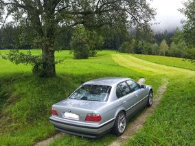
Our trusty hashcot. Too big to take to the hashpoint though.
View backward, towards where we came from.

patrizius checking the coordinates.
GPS is a fickle beast sometimes.
Pretty much there...
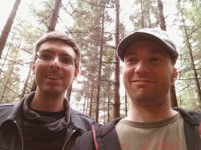
At the hash. Stupid grin(tm).
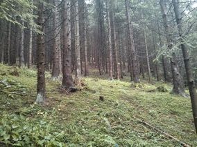
The hashpoint from afar aka "Fairy woods bonus stage ;)".
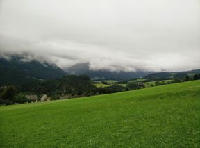
A nice view over the valley.
Proof.
More proof.


Achievements
Patrizius earned the Graticule Unlocked Achievement
|
B2c earned the Graticule Unlocked Achievement
|