Difference between revisions of "2014-09-05 48 16"
From Geohashing
imported>Patrizius (→Photos) |
imported>B2c |
||
| Line 1: | Line 1: | ||
| − | |||
| − | |||
| − | |||
| − | |||
| − | |||
| − | |||
| − | |||
| − | |||
| − | |||
| − | |||
{{meetup graticule | {{meetup graticule | ||
| lat=48 | | lat=48 | ||
| Line 15: | Line 5: | ||
}} | }} | ||
| − | |||
__NOTOC__ | __NOTOC__ | ||
== Location == | == Location == | ||
| − | |||
The hash was located on a field near the L6 between Deutsch-Wagram and Wolkersdorf. The location looked very accessible from the satellite photos. | The hash was located on a field near the L6 between Deutsch-Wagram and Wolkersdorf. The location looked very accessible from the satellite photos. | ||
| Line 26: | Line 14: | ||
== Plans == | == Plans == | ||
| − | |||
The plan was to get there, park the car as close to the hash as possible and make the rest of the way on foot. The hash seemed to be quite close to the small access road, so no big deal. | The plan was to get there, park the car as close to the hash as possible and make the rest of the way on foot. The hash seemed to be quite close to the small access road, so no big deal. | ||
== Expedition == | == Expedition == | ||
| − | |||
Everything went according to plan. The access road was indeed accessible and we could park the hashmobile right beside the field where the hash was located. As a matter of fact the spot turned out to be only 65 meters from where we were parking. On the field there were no crops, no grass, no nothing, so the rest was a matter of seconds. | Everything went according to plan. The access road was indeed accessible and we could park the hashmobile right beside the field where the hash was located. As a matter of fact the spot turned out to be only 65 meters from where we were parking. On the field there were no crops, no grass, no nothing, so the rest was a matter of seconds. | ||
| − | |||
| − | |||
== Tracklog == | == Tracklog == | ||
| − | |||
== Photos == | == Photos == | ||
| − | + | <gallery caption="Photo Gallery" widths="320px" heights="213px" perrow="3"> | |
| − | |||
| − | |||
| − | <gallery perrow=" | ||
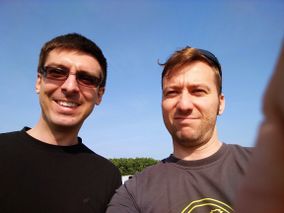
Image:IMG_20140905_093517.jpg | Image:IMG_20140905_093517.jpg | ||
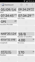
Image:Screenshot_2014-09-05-09-34-32.png | Image:Screenshot_2014-09-05-09-34-32.png | ||
| Line 48: | Line 28: | ||
== Achievements == | == Achievements == | ||
| − | |||
| − | |||
| − | |||
| − | |||
| − | |||
| − | |||
| − | |||
| − | |||
| − | |||
| − | |||
[[Category:Expedition planning]] | [[Category:Expedition planning]] | ||
| − | |||
| − | |||
| − | |||
[[Category:Expeditions]] | [[Category:Expeditions]] | ||
| − | |||
[[Category:Expeditions with photos]] | [[Category:Expeditions with photos]] | ||
| − | [[Category: | + | [[Category:Expedition with GPS]] |
| − | |||
| − | |||
| − | |||
| − | |||
[[Category:Coordinates reached]] | [[Category:Coordinates reached]] | ||
| − | + | [[Category: Meetup on 2014-09-05]] | |
| − | + | [[Category: Meetup in 48 16]] | |
| − | |||
| − | |||
| − | |||
| − | |||
| − | |||
| − | |||
| − | |||
| − | [[Category: | ||
| − | |||
| − | |||
| − | |||
| − | |||
| − | |||
| − | [[Category: | ||
| − | |||
| − | |||
Revision as of 09:11, 5 September 2014
| Fri 5 Sep 2014 in 48,16: 48.3354084, 16.5366713 geohashing.info google osm bing/os kml crox |
Location
The hash was located on a field near the L6 between Deutsch-Wagram and Wolkersdorf. The location looked very accessible from the satellite photos.
Participants
Plans
The plan was to get there, park the car as close to the hash as possible and make the rest of the way on foot. The hash seemed to be quite close to the small access road, so no big deal.
Expedition
Everything went according to plan. The access road was indeed accessible and we could park the hashmobile right beside the field where the hash was located. As a matter of fact the spot turned out to be only 65 meters from where we were parking. On the field there were no crops, no grass, no nothing, so the rest was a matter of seconds.
Tracklog
Photos
- Photo Gallery