Difference between revisions of "2014-09-08 -6 106"
imported>ARizqiP (Created page with "{{subst:Expedition |lat = -6 |lon = 106 |date = 2014-09-08 }}") |
m (per Renaming Proposal) |
||
| (12 intermediate revisions by 3 users not shown) | |||
| Line 15: | Line 15: | ||
}} | }} | ||
| − | + | ||
__NOTOC__ | __NOTOC__ | ||
== Location == | == Location == | ||
| − | + | ||
| + | Southern wall of Gedung Fortune, Jl. Mampang Prapatan No. 96, South Jakarta. | ||
== Participants == | == Participants == | ||
| − | + | ||
| − | + | * [[User:ARizqiP|ARizqiP]] | |
== Plans == | == Plans == | ||
| − | + | ||
| + | Thanks to Dow Jones and [[30W|30W rule]], coordinates for Saturday till Monday in this graticule is generated at Friday night. Checking coordinates for the weekend (and weekstart), only the Monday hash is located in Jakarta. Because the hash is in downtown and on the edge of a building, there's a greater chance for me to actually get this hash (after a [[No trespassing consolation prize]] on [[2014-09-04 -6 106|last expedition]]). Free time between my Monday classes also provides a good opportunity for nice pictures. | ||
== Expedition == | == Expedition == | ||
| − | |||
| − | + | At 10:15am, after a morning class and a meal, I departed from my campus. Took a short train ride to Kalibata Station. Since I didn't remember which minibuses goes to the area of the hash (minibuses here literally have no map of their services and most of them only have line number and names of end areas printed on their body, in which I couldn't find the area I headed to), I took the hard way, a 3km walk from the station to the hash. | |
| − | + | ||
| + | At about 12:20pm, I arrived at the building. There I needed some time to mentally figure where exactly is the hash from Google Satellite images since the GPS pointer in my phone is off by more than 20m. Figured, it's just at the outside of the wall, behind parked cars, on an AC outdoor unit. Check! After some nice photos, I headed back to campus because I have a class at 4pm and (I believe) there's no other geohasher in this city. | ||
| + | |||
== Photos == | == Photos == | ||
| − | + | ||
| − | |||
| − | |||
<gallery perrow="5"> | <gallery perrow="5"> | ||
| + | Image:Geohash 2014-09-08 -6 106 location.jpg | After a mental calculation, I determined that the hash pointed to this thing. | ||
| + | Image:Geohash 2014-09-08 -6 106 ARizqiP.jpg | In front of the thing (thought to be) pointed by the hash. Elbow touched the thing. | ||
</gallery> | </gallery> | ||
== Achievements == | == Achievements == | ||
{{#vardefine:ribbonwidth|800px}} | {{#vardefine:ribbonwidth|800px}} | ||
| − | |||
| + | {{Graticule unlocked | ||
| + | |||
| + | | latitude = -6 | ||
| + | | longitude = 106 | ||
| + | | date = 2014-09-08 | ||
| + | | name = ARizqiP | ||
| + | |||
| + | }} | ||
| + | |||
| + | {{Land geohash | ||
| − | + | | latitude = -6 | |
| − | + | | longitude = 106 | |
| − | + | | date = 2014-09-08 | |
| + | | name = ARizqiP | ||
| − | + | }} | |
| − | |||
| − | |||
| − | |||
| − | |||
| − | |||
[[Category:Expeditions]] | [[Category:Expeditions]] | ||
| − | |||
[[Category:Expeditions with photos]] | [[Category:Expeditions with photos]] | ||
| − | |||
| − | |||
| − | |||
| − | |||
| − | |||
| − | |||
| − | + | [[Category:Coordinates reached]] | |
| − | [[Category:Coordinates | + | {{location|ID|JW|JK}} |
| − | |||
| − | |||
| − | |||
| − | |||
| − | |||
| − | |||
| − | |||
| − | |||
| − | |||
| − | |||
| − | |||
| − | |||
| − | |||
| − | |||
Latest revision as of 05:08, 20 March 2024
| Mon 8 Sep 2014 in -6,106: -6.2515374, 106.8272553 geohashing.info google osm bing/os kml crox |
Location
Southern wall of Gedung Fortune, Jl. Mampang Prapatan No. 96, South Jakarta.
Participants
Plans
Thanks to Dow Jones and 30W rule, coordinates for Saturday till Monday in this graticule is generated at Friday night. Checking coordinates for the weekend (and weekstart), only the Monday hash is located in Jakarta. Because the hash is in downtown and on the edge of a building, there's a greater chance for me to actually get this hash (after a No trespassing consolation prize on last expedition). Free time between my Monday classes also provides a good opportunity for nice pictures.
Expedition
At 10:15am, after a morning class and a meal, I departed from my campus. Took a short train ride to Kalibata Station. Since I didn't remember which minibuses goes to the area of the hash (minibuses here literally have no map of their services and most of them only have line number and names of end areas printed on their body, in which I couldn't find the area I headed to), I took the hard way, a 3km walk from the station to the hash.
At about 12:20pm, I arrived at the building. There I needed some time to mentally figure where exactly is the hash from Google Satellite images since the GPS pointer in my phone is off by more than 20m. Figured, it's just at the outside of the wall, behind parked cars, on an AC outdoor unit. Check! After some nice photos, I headed back to campus because I have a class at 4pm and (I believe) there's no other geohasher in this city.
Photos
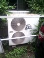
After a mental calculation, I determined that the hash pointed to this thing.
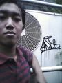
In front of the thing (thought to be) pointed by the hash. Elbow touched the thing.


Achievements
ARizqiP earned the Graticule Unlocked Achievement
|
ARizqiP earned the Land geohash achievement
|