Difference between revisions of "2014-09-10 -35 149"
imported>1PE (→Photos) |
imported>FippeBot m (Location) |
||
| (2 intermediate revisions by 2 users not shown) | |||
| Line 29: | Line 29: | ||
== Expedition == | == Expedition == | ||
===[[User:1PE|1PE]]=== | ===[[User:1PE|1PE]]=== | ||
| − | I drove to the side-street near the hash, and turned left to get a picture of the curious church overlooking the hash: Macedonian | + | I drove to the side-street near the hash, and turned left to get a picture of the curious church overlooking the hash: Macedonian Orthodox Church of St Kliment of Ohrid. |
Then, I drove past the end of the access track to beside the hash, but I needed a 4WD to get up the concrete gutter, so turned onto 4-lane Hindmarsh Drive and parked beside the access track. | Then, I drove past the end of the access track to beside the hash, but I needed a 4WD to get up the concrete gutter, so turned onto 4-lane Hindmarsh Drive and parked beside the access track. | ||
| Line 49: | Line 49: | ||
Image:2014-09-10_13.40.50_-35_149.jpg|Over Hindmarsh Drive, a farm (left) and the former youth correctional centre (right). | Image:2014-09-10_13.40.50_-35_149.jpg|Over Hindmarsh Drive, a farm (left) and the former youth correctional centre (right). | ||
Image:2014-09-10_13.41.09_-35_149.jpg|Up the track. | Image:2014-09-10_13.41.09_-35_149.jpg|Up the track. | ||
| + | Image:2014-09-10_13.40.33_-35_149.jpg|There's an apartment block through the fence. | ||
| + | Image:20140910_-34_149.jpg|Macedonian Orthodox Church of St Kliment of Ohrid | ||
| + | |||
</gallery> | </gallery> | ||
| Line 55: | Line 58: | ||
<!-- Add any achievement ribbons you earned below, or remove this section --> | <!-- Add any achievement ribbons you earned below, or remove this section --> | ||
| − | |||
| − | |||
| − | |||
| − | |||
| − | |||
| − | |||
| − | |||
| − | |||
| − | |||
| − | |||
| − | |||
[[Category:Expeditions]] | [[Category:Expeditions]] | ||
[[Category:Coordinates reached]] | [[Category:Coordinates reached]] | ||
| − | |||
| − | |||
| − | |||
[[Category:Expeditions with photos]] | [[Category:Expeditions with photos]] | ||
| − | + | {{location|AU|ACT}} | |
| − | |||
| − | |||
| − | |||
| − | |||
| − | |||
| − | |||
| − | |||
| − | |||
| − | |||
| − | |||
| − | |||
| − | |||
| − | |||
| − | |||
| − | |||
| − | |||
| − | |||
| − | |||
| − | |||
| − | |||
| − | |||
| − | |||
| − | |||
Latest revision as of 01:21, 15 August 2019
| Wed 10 Sep 2014 in -35,149: -35.3448823, 149.1413950 geohashing.info google osm bing/os kml crox |
Location
On the gas pipe easement beside Hindmarsh Drive, Red Hill. Very close to my drive-through hash on 2012-08-07.
Participants
Plans
1PE
I was going to a meeting at about midday, not a great distance from the hash. After the meeting, I diverted by the hash.
Expedition
1PE
I drove to the side-street near the hash, and turned left to get a picture of the curious church overlooking the hash: Macedonian Orthodox Church of St Kliment of Ohrid.
Then, I drove past the end of the access track to beside the hash, but I needed a 4WD to get up the concrete gutter, so turned onto 4-lane Hindmarsh Drive and parked beside the access track.
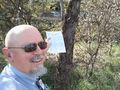
I walked about 200m along the track for the gas pipe easement to where the hash was, and checked using the Geohash Driod app. It was also easy to eyeball the adjoining appartment block just through the barbed wire fence for further confirmation that I was at the hash.
I documented the visit with pictures, including out over the adjoining farm fields and up at the appartment block.
Tracklog
Photos
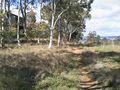
There's a track to the hash, along the gas pipeline.

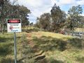
Close, really close, according to the device.
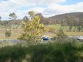
Over Hindmarsh Drive, a farm (left) and the former youth correctional centre (right).
Up the track.
There's an apartment block through the fence.
Macedonian Orthodox Church of St Kliment of Ohrid


