Difference between revisions of "2014-09-18 48 16"
imported>B2c m (→Photos) |
imported>FippeBot m (Location) |
||
| (5 intermediate revisions by 2 users not shown) | |||
| Line 18: | Line 18: | ||
== Expedition == | == Expedition == | ||
| − | Although the hashpoint was located only about 50km outside of Vienna it took them more than an hour to get there as most of the way led over old federal roads which limited | + | Although the hashpoint was located only about 50km outside of Vienna it took them more than an hour to get there as most of the way led over old federal roads which limited their speed. So they had a nice chat regarding the upcoming weekend as they zig-zagged their way through Pröllistan hills (local speak for Lower Austria) towards the hashpoint. When they finally got there they thought the hashpoint would be located within a cornfield, but luckily it turned out otherwise. They changed into 'proper' footwear and walked about 20m into a dry field, startling some rabbits and a chicken. On the hash they grinned stupidly, took some pictures and where on their way home again. |
== Tracklog == | == Tracklog == | ||
| Line 25: | Line 25: | ||
== Photos == | == Photos == | ||
<gallery caption="Photo Gallery" widths="320px" heights="213px" perrow="3"> | <gallery caption="Photo Gallery" widths="320px" heights="213px" perrow="3"> | ||
| − | |||
Image:IMG_20140918_patonhash.jpg | Patrizius near the hashpoint. | Image:IMG_20140918_patonhash.jpg | Patrizius near the hashpoint. | ||
Image:IMG_20140918_kleinbaumgarten.jpg | The village Kleinbaumgarten in the distance. | Image:IMG_20140918_kleinbaumgarten.jpg | The village Kleinbaumgarten in the distance. | ||
| Line 32: | Line 31: | ||
Image:IMG_20140918_hash-rabbits.jpg | Two rabbits on the run. Magnifier anyone? | Image:IMG_20140918_hash-rabbits.jpg | Two rabbits on the run. Magnifier anyone? | ||
Image:IMG_20140918_hashpoint.jpg | The hashpoint. | Image:IMG_20140918_hashpoint.jpg | The hashpoint. | ||
| − | Image: | | + | Image:IMG_20140918_grin.jpg | Stupid grin(tm). |
Image:Screenshot_2014-09-18-proof.png | Proof. | Image:Screenshot_2014-09-18-proof.png | Proof. | ||
| − | Image: | More proof. | + | Image:Screenshot_2014-09-18-18-39-patgps.png | More proof. |
Image:Gpsvisualizer-2014-09-18-wien_detail.png | Detailed tracklog of the hashpoint. | Image:Gpsvisualizer-2014-09-18-wien_detail.png | Detailed tracklog of the hashpoint. | ||
</gallery> | </gallery> | ||
| Line 55: | Line 54: | ||
| − | |||
[[Category:Expeditions]] | [[Category:Expeditions]] | ||
[[Category:Expeditions with photos]] | [[Category:Expeditions with photos]] | ||
[[Category:Coordinates reached]] | [[Category:Coordinates reached]] | ||
| + | {{location|AT|NÖ|MI}} | ||
Latest revision as of 01:30, 15 August 2019
| Thu 18 Sep 2014 in 48,16: 48.6726037, 16.3723531 geohashing.info google osm bing/os kml crox |
Location

The hash was located in a field between Unterstinkenbrunn (yes, exactly...) and Hagendorf about 50km north of Vienna.
Participants
Plans
As the hash seemed easily reachable from a nearby access road the hashmen took a more spontaneous approach at this one.
Expedition
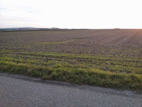
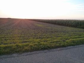
Although the hashpoint was located only about 50km outside of Vienna it took them more than an hour to get there as most of the way led over old federal roads which limited their speed. So they had a nice chat regarding the upcoming weekend as they zig-zagged their way through Pröllistan hills (local speak for Lower Austria) towards the hashpoint. When they finally got there they thought the hashpoint would be located within a cornfield, but luckily it turned out otherwise. They changed into 'proper' footwear and walked about 20m into a dry field, startling some rabbits and a chicken. On the hash they grinned stupidly, took some pictures and where on their way home again.
Tracklog

Photos
- Photo Gallery

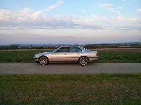
Patrizius near the hashpoint.
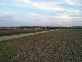
The village Kleinbaumgarten in the distance.
Trusty hashcot takes a rest while we venture into the fields.
A chicken in the distance. It is not impressed.
Two rabbits on the run. Magnifier anyone?
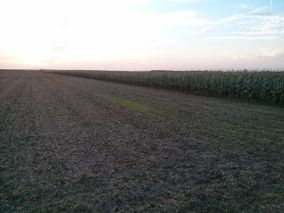
The hashpoint.

Stupid grin(tm).
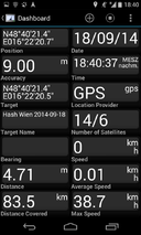
Proof.
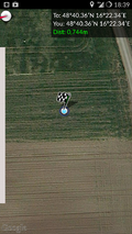
More proof.
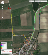
Detailed tracklog of the hashpoint.


Achievements
B2c earned the Consecutive geohash achievement
|
Patrizius earned the Consecutive geohash achievement
|