Difference between revisions of "2014-09-19 50 7"
imported>Patrizius |
imported>FippeBot m (Location) |
||
| (7 intermediate revisions by 3 users not shown) | |||
| Line 1: | Line 1: | ||
| − | + | {{meetup graticule | |
| − | |||
| − | |||
| − | |||
| − | |||
| − | |||
| − | |||
| − | |||
| − | |||
| − | |||
| − | |||
| lat=50 | | lat=50 | ||
| lon=7 | | lon=7 | ||
| date=2014-09-19 | | date=2014-09-19 | ||
| − | }} | + | }} |
| − | |||
__NOTOC__ | __NOTOC__ | ||
== Location == | == Location == | ||
| − | The hash was located on top of a | + | The hash was located on top of a store building. |
| + | |||
== Participants == | == Participants == | ||
| − | + | * [[User:Patrizius|Patrizius]] | |
| − | |||
== Plans == | == Plans == | ||
| − | + | I was travelling to Düsseldorf by train.During the trip I checked out the hashpoint. The closest hash appeared to be deep in the woods, which was not | |
| − | I was travelling to Düsseldorf by train. During the trip I checked out the hashpoint. The closest hash appeared to be deep in the woods, which was not ideal since I was wearing a suit and some nice dress shoes. So I decided to go for another hash, which was about 110 kilometers away. From the satellite images it looked like the hash was located on top of a building which was part of a shopping center with big parking lots in between. Plenty of tarmac.. Wouldn't wanna ruin my good shoes, would I? ;) | + | ideal since I was wearing a suit and some nice dress shoes. :) |
| + | |||
| + | So I decided to go for another hash, which was about 110 kilometers away. From the satellite images it looked like the hash was located on top of a building which was part of a shopping center with big parking lots in between. Plenty of tarmac.. Wouldn't wanna ruin my good shoes, would I? ;) | ||
== Expedition == | == Expedition == | ||
| − | + | ||
Arriving at Düsseldorf main station I immediately boarded a rental car, a BMW 740i. I entered the coordinates into the beamers satnav and took off. There was heavy traffic, so I was a bit concerned not making the hash in time due to a roadblock. But I arrived at the scene with plenty of time to spare. At the parking lot I approached the hash hugging the wall of the building passing a huge billboard on the way. At the corner of the building I realized I wouldn't be getting any closer to the hashpoint so I snapped a few pics, got back into the car and took off, only stopping at McDonalds for refreshments. | Arriving at Düsseldorf main station I immediately boarded a rental car, a BMW 740i. I entered the coordinates into the beamers satnav and took off. There was heavy traffic, so I was a bit concerned not making the hash in time due to a roadblock. But I arrived at the scene with plenty of time to spare. At the parking lot I approached the hash hugging the wall of the building passing a huge billboard on the way. At the corner of the building I realized I wouldn't be getting any closer to the hashpoint so I snapped a few pics, got back into the car and took off, only stopping at McDonalds for refreshments. | ||
*Clock! -- [[User:Patrizius|Patrizius]] ([[User talk:Patrizius|talk]]) [http://www.openstreetmap.org/?lat=50.88686501&lon=7.63448480&zoom=16&layers=B000FTF @50.8869,7.6345] 21:11, 19 September 2014 (CEST) | *Clock! -- [[User:Patrizius|Patrizius]] ([[User talk:Patrizius|talk]]) [http://www.openstreetmap.org/?lat=50.88686501&lon=7.63448480&zoom=16&layers=B000FTF @50.8869,7.6345] 21:11, 19 September 2014 (CEST) | ||
| − | |||
| − | |||
== Photos == | == Photos == | ||
| − | |||
| − | |||
| − | |||
<gallery perrow="5"> | <gallery perrow="5"> | ||
| + | Image: Download_20140919_201221.jpeg | coordinates set | ||
| + | Image:IMG_20140919_210403.jpg | The spot on the beamers satnav | ||
| + | Image:IMG_20140919_210701.jpg | Approaching the store building | ||
| + | Image:IMG_20140919_211132.jpg | The spot on the side of the building. | ||
| + | Image:IMG_20140919_211208.jpg | Me clocking in. Formal attire.. check | ||
| + | Image:IMG_20140919_211523.jpg | Parking lot of the store. | ||
| + | Image:tracklog_waldbröl.png | Tracklog | ||
</gallery> | </gallery> | ||
== Achievements == | == Achievements == | ||
{{#vardefine:ribbonwidth|800px}} | {{#vardefine:ribbonwidth|800px}} | ||
| − | + | {{Formal attire | |
| − | + | | latitude = 50 | |
| − | + | | longitude = 7 | |
| − | + | | date = 2014-09-19 | |
| − | + | | name = Patrizius | |
| − | + | | image = IMG_20140919_211208.jpg | |
| − | + | }} | |
| − | + | {{consecutive geohash 2 | |
| + | | count = 17 | ||
| + | | latitude = 47 | ||
| + | | longitude = 14 | ||
| + | | date = 2014-09-03 | ||
| + | | name = Patrizius | ||
| + | }} | ||
| − | |||
| − | |||
| − | |||
| − | |||
| − | |||
| − | |||
[[Category:Expeditions]] | [[Category:Expeditions]] | ||
| − | |||
[[Category:Expeditions with photos]] | [[Category:Expeditions with photos]] | ||
| − | |||
| − | |||
| − | |||
| − | |||
| − | |||
[[Category:Coordinates reached]] | [[Category:Coordinates reached]] | ||
| − | + | <!-- * No Trespassing (patrizius: Trespassing?? Please elaborate.) --> | |
| − | + | {{location|DE|NW|GM}} | |
| − | |||
| − | |||
| − | |||
| − | |||
| − | |||
| − | |||
| − | |||
| − | |||
| − | |||
| − | |||
| − | |||
| − | |||
| − | |||
| − | |||
| − | |||
| − | |||
Latest revision as of 00:34, 7 August 2019
| Fri 19 Sep 2014 in 50,7: 50.8867517, 7.6346360 geohashing.info google osm bing/os kml crox |
Location
The hash was located on top of a store building.
Participants
Plans
I was travelling to Düsseldorf by train.During the trip I checked out the hashpoint. The closest hash appeared to be deep in the woods, which was not ideal since I was wearing a suit and some nice dress shoes. :)
So I decided to go for another hash, which was about 110 kilometers away. From the satellite images it looked like the hash was located on top of a building which was part of a shopping center with big parking lots in between. Plenty of tarmac.. Wouldn't wanna ruin my good shoes, would I? ;)
Expedition
Arriving at Düsseldorf main station I immediately boarded a rental car, a BMW 740i. I entered the coordinates into the beamers satnav and took off. There was heavy traffic, so I was a bit concerned not making the hash in time due to a roadblock. But I arrived at the scene with plenty of time to spare. At the parking lot I approached the hash hugging the wall of the building passing a huge billboard on the way. At the corner of the building I realized I wouldn't be getting any closer to the hashpoint so I snapped a few pics, got back into the car and took off, only stopping at McDonalds for refreshments.
- Clock! -- Patrizius (talk) @50.8869,7.6345 21:11, 19 September 2014 (CEST)
Photos
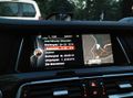
coordinates set
The spot on the beamers satnav

Approaching the store building
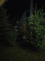
The spot on the side of the building.

Me clocking in. Formal attire.. check

Parking lot of the store.
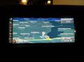
Tracklog


Achievements
Patrizius earned the Formal attire achievement
|
Patrizius earned the Consecutive geohash achievement
|