Difference between revisions of "2014-09-20 45 16"
imported>GeoEdo (→Photos) |
imported>GeoEdo (→Photos) |
||
| Line 32: | Line 32: | ||
Image:2014-09-20_45-16_4.jpg|View from hashpoint towards south-east | Image:2014-09-20_45-16_4.jpg|View from hashpoint towards south-east | ||
Image:2014-09-20_45-16_5.jpg|Actual hashpoint marked with my jacket | Image:2014-09-20_45-16_5.jpg|Actual hashpoint marked with my jacket | ||
| − | Image:2014-09-20_45-16_6.jpg|Closer | + | Image:2014-09-20_45-16_6.jpg|Closer look at actual hashpoint |
Image:2014-09-20_45-16_7.jpg|View towards hashpoint from nearby dirt road | Image:2014-09-20_45-16_7.jpg|View towards hashpoint from nearby dirt road | ||
Image:2014-09-20_45-16_8.jpg|hashpoint surrounding viewed from dirt road | Image:2014-09-20_45-16_8.jpg|hashpoint surrounding viewed from dirt road | ||
Revision as of 14:03, 20 September 2014
| Sat 20 Sep 2014 in 45,16: 45.7528903, 16.1550111 geohashing.info google osm bing/os kml crox |
Location
Near Strmec Bukevski, a small village with 390 inhabitants, that live in 114 households. The population density is 67,01 pop./km². Total area of the village is 5,82 km². It is located in geographical region of Turopolje and administratively it is part of Velika Gorica city.
Participants
Plans
No real plans. I just check my four nearby graticules each day to see if there are any doable hashpoints for me to visit. Today this haspointon appeared on my maps, so I went to visit it.
Expedition
Today I managed to go on my first geohashing expedition. This hashpoint is 11.95 kilometers from my home (as the crow flies). I took this expedition with my car. I took D31 road to Crnkovec and then took local road to Strmec Bukevski. Just before entering Strmec Bukevski I turned left on a dirt road that took me some 90 meters from this hashpoint. The hashpoint was located on middle of a meadow. There were some traces from some kind of vehicle on the meadow and they led almost directly towards hashpoint. I left my car on the middle of dirt road and proceed towards hashpoint on foot. Grass was quite wet from all the rain these days. I managed to get right to the ground zero and was quite happy I scored my first hashpoint. Took some pictures from the hashpoint and marked hashpoint with my jacket and took picture of hashpoint as well. I notice some locals some 200 meters ahead but didn't paid attention to them. Went back to car and started driving again. Then I noticed one of locals on his four-wheeler quad is driving after me. Since I had to turn my car on dirt road he catch-up with me, so I opened my car window. He was friendly but asked if I was seeking someone. I explained him the concept of geohashing game and he was satisfied with the explanation, so we exchanged greetings and split in peace and mutual understanding. As I drove away from my first hashpoint, it started to rain again, quite heavy. It was a nice geohashing expedition and I hope one of nearby graticules will have some doable hashpoints soon.
Photos
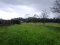
View from hashpoint towards north-east
View from hashpoint towards north-west
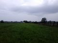
View from hashpoint towards south-west
View from hashpoint towards south-east
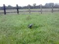
Actual hashpoint marked with my jacket
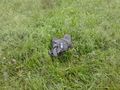
Closer look at actual hashpoint
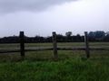
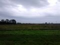
View towards hashpoint from nearby dirt road
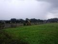
hashpoint surrounding viewed from dirt road
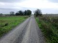
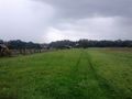
Dirt road that leads near hashpoint
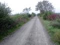
Dirt road that leads near hashpoint


