Difference between revisions of "2014-09-28 48 11"
imported>Umeier |
imported>FippeBot m (Location) |
||
| (3 intermediate revisions by 2 users not shown) | |||
| Line 17: | Line 17: | ||
| − | + | ||
__NOTOC__ | __NOTOC__ | ||
== Location == | == Location == | ||
| − | + | ||
| − | The hash | + | The hash lay between Schöngeising and Landsberied north of the old romanian street "Via Julia". |
== Participants == | == Participants == | ||
| − | + | ||
| − | + | * [[User:Umeier|Umeier]] | |
| − | [[User:Umeier|Umeier]] | + | * Wife |
== Plans == | == Plans == | ||
| − | + | ||
Cycling | Cycling | ||
== Expedition == | == Expedition == | ||
| − | + | ||
My wife and I started in Taufkirchen at 12:00, crossed the Isar at the Großhesseloher Brücke and turned south to Baierbrunn-Buchenhain where we came upon the so called "Via Julia", a cycle-route following an old romanian street. | My wife and I started in Taufkirchen at 12:00, crossed the Isar at the Großhesseloher Brücke and turned south to Baierbrunn-Buchenhain where we came upon the so called "Via Julia", a cycle-route following an old romanian street. | ||
| Line 44: | Line 44: | ||
Then we took the same way home. | Then we took the same way home. | ||
| − | |||
== Photos == | == Photos == | ||
| − | + | ||
| − | |||
| − | |||
<gallery perrow="5"> | <gallery perrow="5"> | ||
Image:2014-09-28 48 11 Umeier proof.png | Proof | Image:2014-09-28 48 11 Umeier proof.png | Proof | ||
| Line 60: | Line 57: | ||
<!-- Add any achievement ribbons you earned below, or remove this section --> | <!-- Add any achievement ribbons you earned below, or remove this section --> | ||
| + | * Land Geohash | ||
| + | * Bike Geohash | ||
| − | + | [[Category:Expeditions]] | |
| − | |||
| − | [[Category: | ||
| − | |||
| − | |||
| − | |||
| − | |||
| − | |||
| − | |||
| − | |||
| − | |||
| − | |||
| − | |||
[[Category:Expeditions with photos]] | [[Category:Expeditions with photos]] | ||
| − | |||
| − | |||
| − | |||
| − | |||
[[Category:Coordinates reached]] | [[Category:Coordinates reached]] | ||
| − | + | {{location|DE|BY|FFB}} | |
| − | |||
| − | |||
| − | |||
| − | |||
| − | |||
| − | |||
| − | |||
| − | |||
| − | |||
| − | |||
| − | |||
| − | |||
| − | |||
| − | |||
| − | |||
| − | |||
| − | |||
| − | |||
| − | |||
Latest revision as of 01:37, 15 August 2019
| Sun 28 Sep 2014 in 48,11: 48.1497133, 11.1861790 geohashing.info google osm bing/os kml crox |
Location
The hash lay between Schöngeising and Landsberied north of the old romanian street "Via Julia".
Participants
- Umeier
- Wife
Plans
Cycling
Expedition
My wife and I started in Taufkirchen at 12:00, crossed the Isar at the Großhesseloher Brücke and turned south to Baierbrunn-Buchenhain where we came upon the so called "Via Julia", a cycle-route following an old romanian street.
Via Julia led us west through the Forstenrieder Part, to Buchendorf and Gauting, Gilching and Schöngeising.
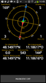
A short way behind the railway-crossing in Schöngeising, north of the road to Landsberied, the GPS showed me that the geohash was near the road in the forest.
After visiting the hash, fitting the poster and taking the photo we went to Jesenwang Airport to have a cup of coffe and a piece of cake.
Then we took the same way home.
Photos
Proof

More photos to come ...
Achievements
- Land Geohash
- Bike Geohash