Difference between revisions of "2014-10-07 39 -89"
imported>Mystrsyko (→Photos) |
imported>FippeBot m (Location) |
||
| (2 intermediate revisions by one other user not shown) | |||
| Line 65: | Line 65: | ||
== Achievements == | == Achievements == | ||
{{#vardefine:ribbonwidth|800px}} | {{#vardefine:ribbonwidth|800px}} | ||
| − | + | {{land geohash | |
| + | | latitude = 39 | ||
| + | | longitude = -89 | ||
| + | | date = 2014-10-07 | ||
| + | | name = Mystrsyko & DolphinTreasure | ||
| − | + | }} | |
| − | |||
| − | |||
| − | + | {{bicycle geohash | |
| − | + | | latitude = 39 | |
| − | + | | longitude = -89 | |
| − | + | | date = 2014-10-07 | |
| − | + | | name = Mystrsyko & DolphinTreasure | |
| + | | distance = 18 miles | ||
| − | + | }} | |
| − | |||
| − | |||
| − | |||
| − | |||
| − | |||
| − | |||
| − | |||
| − | |||
| − | |||
| + | {{gratuitous ribbon | ||
| − | + | | icon = Holyhash.png | |
| − | + | | latitude = 39 | |
| − | -- | + | | longitude = -89 |
| − | + | | date = 2014-10-07 | |
| − | + | | achievement = Holy Hash Honorable Mention | |
| − | + | | description = reaching the geohash located 400 feet away from a church. | |
| − | + | | name = Mystrsyko & DolphinTreasure | |
| − | |||
| − | + | }} | |
| − | |||
| − | |||
| − | |||
| − | |||
| − | + | [[Category:Expeditions]] | |
| + | [[Category:Expeditions with photos]] | ||
| + | [[Category:Coordinates reached]] | ||
| + | [[Category:Holy hash achievement]] | ||
| + | {{location|US|IL|SM}} | ||
Latest revision as of 01:41, 15 August 2019
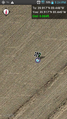
| Tue 7 Oct 2014 in 39,-89: 39.9172912, -89.4458082 geohashing.info google osm bing/os kml crox |
Location
Just off a road near Cornland, Illinois
Participants
Plans
To bike there starting around 11:30
Expedition
Today happened to be a day I (Mystrsyko) had off work that I had already planned a long bike ride around town. When I saw the coordinates were only about 18 miles from home, I thought about biking to the hash instead. However, it was in a farmer's field, not far from what looked like a home on the aerial photos. Since harvest has only just begun, I was fairly confident it would end in a "No Tresspassing" consolation prize, but was willing to make the attempt anyway. DolphinTreasure thought it would make a great day out and decided to come with. It would be her first bike hash and the longest bike ride either of us had ever attempted.
Coordinates were printed, typed into the gps, and we let it guide us through town on our way out to the hash. We tried to maintain a slow-but-steady pace to save energy, knowing that we had to fight a headwind on the way home. On the outskirts of town we passed a small bar near the halfway point and I made a mental note that it would be a great place to stop and rest on the way home.
Outside of town, we were treated to sights that rarely present themselves when not geohashing, and the fact that we were on bikes and not in a car watching things through the window meant we could experience them all the more. Sights that warrented stopping for photos included a christmas tree farm and a farmer harvesting his crop of corn. The latter gave me hope that maybe, just maybe, the hash field was already harvested and we wouldn't need to worry about damaging crops.
After an hour and a half ride, we approached our turn towards the hash. To our complete surprise, the "house" we thought was overlooking the hash turned out to be a small church! And to top it off, the field had been harvested and nothing stood between us and the hash point.
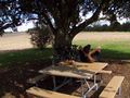
We pulled our bikes up to the church and parked them in a nice little picnic area under a tree. While DolphinTreasure rested, I took some photos of the church and prepared Geohash Droid for guiding us to the point. The point was just a few hundred feet east of the church, and after a short walk, it was ours. Photos were taken and our hashfox Collin was let out to run around. Then we returned to the picnic area to munch on the snacks we brought with and enjoy our accomplishment. Collin chased a ladybug, which was kind enough to sit still while I took a close-up photo of it. We left our business-card geohash marker, prepared our bikes, and began the long journey home. Little did we know the journey had only just begun.
Having a tailwind the whole way to the hash meant we had never really experienced just how windy it was, and after just a few miles, our legs were worn out. DolphinTreasure, not being a cyclist, was having difficulty making any headway in the torrent of rushing air. We stopped just about every mile to rest her legs. Exhausted, we eventually made it to the bar, where we sat down to a drink of fresh, cold water.
The wind took it's toll though, and just after getting back into down, her legs gave out. Somehow, she had managed to will herself 30 miles, six miles short of home. While sitting in the parking lot of a Hardee's, we made the most diffucult of decisions: I would have to carry on without her. With her car keys in hand (actually in pocket), I set out for home.
Surprisingly, I wasn't as tired as I expected to be and made the last 6 miles without too much trouble. After a short rest, I changed out of my sweaty clothes, jumped in her car, and picked up DolphinTreasure and her bike. Then it was off to dinner to have burgers and milkshakes to celebrate our first successful geohash in our new home!
Tracklog
http://www.strava.com/activities/204583588
Photos

DolphinTreasure on her bike
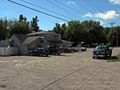
The bar we rested at
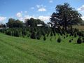
Christmas tree farm
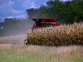
Harvest has begun!
Apparently it's a church and not a house!
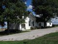
Beautiful small country church
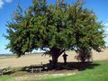
The picnic spot we stopped at. The hash is off to the right

Mystrsyko near the hash with GPS in hand

We all made it!
What a great day to geohash!

Collin's ladybug
We left our marker in the tree by the picnic table
Geohash Droid proof


Achievements
Mystrsyko & DolphinTreasure earned the Land geohash achievement
|
Mystrsyko & DolphinTreasure earned the Bicycle geohash achievement
|
Mystrsyko & DolphinTreasure earned the Holy Hash Honorable Mention
|