Difference between revisions of "2014-10-11 41 -122"
imported>Thescruffmuffin (Created page with "{{meetup graticule | lat=41 | lon=-122 | date=2014-10-11 }} __NOTOC__ == Location == Near the Iron Gate Reservoir's hydroelectric plant. == Participants == User:thescru...") |
imported>Thescruffmuffin (→Photos) |
||
| Line 21: | Line 21: | ||
<gallery perrow="5"> | <gallery perrow="5"> | ||
| − | + | Image:2014-10-11 41 -122 meetup (2).JPG|The view of Iron Gate Reservoir from where we parked. | |
| − | + | Image:2014-10-11 41 -122 meetup (3).JPG|My trusty toyota that brought us to the geohash. | |
| − | + | Image:2014-10-11 41 -122 meetup (9).JPG|Successfully reached the geohash. | |
| − | + | Image:2014-10-11 41 -122 meetup (16).JPG|This bush marks the saturday geohash! | |
| − | + | Image:2014-10-11 41 -122 meetup (15).JPG|Everyone smile! Except you. xD | |
</gallery> | </gallery> | ||
Revision as of 19:15, 12 October 2014
| Sat 11 Oct 2014 in 41,-122: 41.9322137, -122.4356845 geohashing.info google osm bing/os kml crox |
Location
Near the Iron Gate Reservoir's hydroelectric plant.
Participants
Will, and his two friends Richie & Kelsey
Expedition
The day started off with the three of us heading up to Medford, OR to get some shopping done and we stopped for lunch at Buffalo Wild Wings where we each nearly died from the Mango Habanero sauce on our wings. I highly recommend it (not for the faint of heart)! After lunch this trio headed back down south towards Iron Gate Reservoir. None of the three of us had ever visited the reservoir and we had no clue what could await us there. We headed down a little country road, crossed the Klamath river and headed onto gravel road which shortly transitioned to a rocky dirt road that took us to within a couple of hundred feet of the geohash point. We parked at the top of the hill with an epic view of the reservoir stretching out below us. We followed the GPS to what we thought was the Geohash. Indeed, this was nearly a failed trip. While we were walking a button was accidentally pressed on the GPS and it started to lead us to a point that was a couple hundred feet from the real point. We arrived at that point celebrated our success, took some pictures and declared a dried up old cow patty to be the exact point of the geohash. On our way back to the car, Richie made his suspicions that we hadn't reached the real geohash and we decided to double-check. We told the GPS to take us to the coordinates again and followed it a couple of hundred feet to a different point (down a very steep hill and very close to the hydroelectric plant). We celebrated once more and then decided to head home with this first geohash success under our belts.
Photos
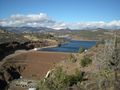
The view of Iron Gate Reservoir from where we parked.
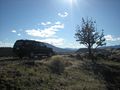
My trusty toyota that brought us to the geohash.
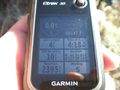
Successfully reached the geohash.
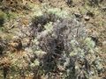
This bush marks the saturday geohash!
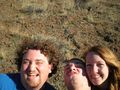
Everyone smile! Except you. xD
.JPG)
.JPG)
.JPG)
.JPG)
.JPG)