Difference between revisions of "2014-10-13 50 5"
imported>Thalweg (Created page with "{{subst:Expedition |lat = 55 |lon = -17 |date = 2012-07-22 }}") |
imported>FippeBot m (Location) |
||
| (13 intermediate revisions by 2 users not shown) | |||
| Line 2: | Line 2: | ||
<!-- If you did not specify these parameters in the template, please substitute appropriate values for IMAGE, LAT, LON, and DATE (YYYY-MM-DD format) | <!-- If you did not specify these parameters in the template, please substitute appropriate values for IMAGE, LAT, LON, and DATE (YYYY-MM-DD format) | ||
| − | [[Image:{{{image| | + | [[Image:{{{image|2014_10_13_5_50_Imperia.jpg}}}|thumb|left]] |
Remove this section if you don't want an image at the top (left) of your report. You should remove the "Image:" or "File:" | Remove this section if you don't want an image at the top (left) of your report. You should remove the "Image:" or "File:" | ||
| Line 10: | Line 10: | ||
--> | --> | ||
{{meetup graticule | {{meetup graticule | ||
| − | | lat= | + | | lat=50 |
| − | | lon= | + | | lon=5 |
| − | | date= | + | | date=2014-10-13 |
}} | }} | ||
| − | + | ||
__NOTOC__ | __NOTOC__ | ||
== Location == | == Location == | ||
| − | + | ||
| + | On a wooden hill near the village of Nessonvaux, Belgium. | ||
== Participants == | == Participants == | ||
| − | |||
| − | |||
| − | + | * [[User:Thalweg|Thalweg]] | |
| − | |||
== Expedition == | == Expedition == | ||
| − | |||
| − | + | I don't have any car, and in my graticule public transports are, at best, scarce. That limit the radius to where I could go. When I saw that's today's hash was less than 10 km away from home, I took my bike and tried to find it. | |
| − | + | ||
| + | First step was to go to the bottom of a valley to cross the river Vesdre (while less than efficient brakes) then find the little road on the right which lead me to another, albeit smaller valley. The hash was on the surrounding hill to the north. I let my bike on the side of the road, then pulled out my phone/GPS to take the direct path, across low trees. Bad idea. After I found some apples and a lot of thorns, I tried to make another attempt, with a less direct approach, a hundred meter to the east. | ||
| + | |||
| + | Attempt number two lead me in a somehow small ancient quarry. I got around climbing one of the side, and again tried the direct route. Again, low trees and thorns. I tried to get to the top of the hill, to find some kind of slope with a flat ground on the top. Using an massive oak, I managed to get on that flat ground. GPS then told me the hash was in the same direction than the path on the ground, so I followed that path for a hundred meters, to find the woods where the hash was. | ||
| + | |||
| + | I took a few pictures, then tried to get back to my bike following the way I took to climb up there. I then fall on barbed wire, which I didn't cross to get there. Trying to avoid this thing, I lamely fall in the slope in a ridiculous way. Fortunately, no harm. I manage to find the old quarry (second ridiculous harmless fall) and get my bike back. I then found two geocaches nearby and logged in, before going back home. | ||
== Photos == | == Photos == | ||
| − | + | ||
| − | |||
| − | |||
<gallery perrow="5"> | <gallery perrow="5"> | ||
| + | Image:2014_10_13_50_5_hill.jpg | Hash is on top of that hill. | ||
| + | Image:2014_10_13_50_5_Apples.jpg | The apples. | ||
| + | Image:2014_10_13_50_5_Oak.jpg | The oak. | ||
| + | Image:2014_10_13_50_5_Proof.png | Arriving on the hash. | ||
| + | Image:2014_10_13_5_50_Imperia.jpg | Old Imperia factory from the top, with ruins of the testing track on the roof. | ||
</gallery> | </gallery> | ||
== Achievements == | == Achievements == | ||
| − | |||
| − | |||
| + | * Bike Geohash | ||
| + | * Land Geohash | ||
| − | |||
| − | |||
| − | |||
| − | |||
| − | |||
| − | |||
| − | |||
| − | |||
| − | |||
| − | |||
[[Category:Expeditions]] | [[Category:Expeditions]] | ||
| − | + | [[Category:Expeditions with photos]] | |
| − | [[Category:Expeditions with photos]] | ||
| − | |||
| − | |||
| − | |||
| − | |||
| − | |||
[[Category:Coordinates reached]] | [[Category:Coordinates reached]] | ||
| − | + | {{location|BE|WLG}} | |
| − | |||
| − | |||
| − | |||
| − | |||
| − | |||
| − | |||
| − | |||
| − | |||
| − | |||
| − | |||
| − | |||
| − | |||
| − | |||
| − | |||
| − | |||
| − | |||
| − | |||
Latest revision as of 01:44, 15 August 2019
| Mon 13 Oct 2014 in 50,5: 50.5805367, 5.7471652 geohashing.info google osm bing/os kml crox |
Location
On a wooden hill near the village of Nessonvaux, Belgium.
Participants
Expedition
I don't have any car, and in my graticule public transports are, at best, scarce. That limit the radius to where I could go. When I saw that's today's hash was less than 10 km away from home, I took my bike and tried to find it.
First step was to go to the bottom of a valley to cross the river Vesdre (while less than efficient brakes) then find the little road on the right which lead me to another, albeit smaller valley. The hash was on the surrounding hill to the north. I let my bike on the side of the road, then pulled out my phone/GPS to take the direct path, across low trees. Bad idea. After I found some apples and a lot of thorns, I tried to make another attempt, with a less direct approach, a hundred meter to the east.
Attempt number two lead me in a somehow small ancient quarry. I got around climbing one of the side, and again tried the direct route. Again, low trees and thorns. I tried to get to the top of the hill, to find some kind of slope with a flat ground on the top. Using an massive oak, I managed to get on that flat ground. GPS then told me the hash was in the same direction than the path on the ground, so I followed that path for a hundred meters, to find the woods where the hash was.
I took a few pictures, then tried to get back to my bike following the way I took to climb up there. I then fall on barbed wire, which I didn't cross to get there. Trying to avoid this thing, I lamely fall in the slope in a ridiculous way. Fortunately, no harm. I manage to find the old quarry (second ridiculous harmless fall) and get my bike back. I then found two geocaches nearby and logged in, before going back home.
Photos
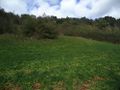
Hash is on top of that hill.
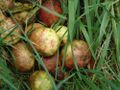
The apples.
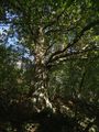
The oak.
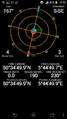
Arriving on the hash.
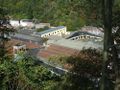
Old Imperia factory from the top, with ruins of the testing track on the roof.


Achievements
- Bike Geohash
- Land Geohash