Difference between revisions of "2014-11-02 48 8"
imported>DODO (Created page with "{{subst:Expedition |lat = 48 |lon = 8 |date = 2014-11-01 }}") |
imported>FippeBot m (Location) |
||
| (10 intermediate revisions by 2 users not shown) | |||
| Line 12: | Line 12: | ||
| lat=48 | | lat=48 | ||
| lon=8 | | lon=8 | ||
| − | | date=2014-11- | + | | date=2014-11-02 |
}} | }} | ||
| Line 19: | Line 19: | ||
== Location == | == Location == | ||
<!-- where you've surveyed the hash to be --> | <!-- where you've surveyed the hash to be --> | ||
| + | In a vineyard above Dietlingen | ||
== Participants == | == Participants == | ||
<!-- who attended: If you link to your wiki user name in this section, your expedition will be picked up by the various statistics generated for geohashing. You may use three tildes ~ as a shortcut to automatically insert the user signature of the account you are editing with. | <!-- who attended: If you link to your wiki user name in this section, your expedition will be picked up by the various statistics generated for geohashing. You may use three tildes ~ as a shortcut to automatically insert the user signature of the account you are editing with. | ||
--> | --> | ||
| + | [[User:DODO|DODO]] | ||
== Plans == | == Plans == | ||
| Line 29: | Line 31: | ||
== Expedition == | == Expedition == | ||
<!-- how it all turned out. your narrative goes here. --> | <!-- how it all turned out. your narrative goes here. --> | ||
| + | After three very easy hashes ([[2014-10-27 49 8|3 KM with my bull]], [[2014-10-28 49 8|car hashing]] and [[2014-11-01 49 8|1000m of walk]]) I had to do a hash that has to be worked for. And so I decided to visit todays nearest hash by bike. | ||
| + | |||
| + | The trip led me35 KM through the upper rhine valley and for the remaining 40 Km through the hills of the Kraichgau. When I reached the Kraichgau in Bruchsal, the sun came through the foggy clouds and the view over the roaring hills, colored by the leaves of the trees and the sun on all that was marvelous. But after a while I got really tired and had to make a short break (and eat something). I found a little chapel on a hill and rested there before I continued. After 15 more KM (mostly upwards) I entered some vineyards and was rewarded by a wonderful view over a small village, two hot-air ballons driving over the landscape and a hashpoint placed in front of me, just 6 m from the path, decorated with some beautiful flowers. | ||
| + | |||
| + | I took another break, did what I had to do (just some pictures, no mark) and continued for the last 10 KM to Pforzheim. With two more hills to there I needed 45 minutes to get there, and then it took me 2 more hours to get back to Speyer by train (could have been 1.16 h, if I would have reached the station at 15:30, but that was obviously to ambitious. Anyway, hashing gave me just another wonderful day out. | ||
== Tracklog == | == Tracklog == | ||
<!-- if your GPS device keeps a log, you may post a link here --> | <!-- if your GPS device keeps a log, you may post a link here --> | ||
| + | [http://www.gpsies.com/map.do?fileId=rlljwwrhzpfgfeav 80 KM bike + 87 KM train] | ||
== Photos == | == Photos == | ||
| Line 37: | Line 45: | ||
Image:2012-##-## ## ## Alpha.jpg | Witty Comment | Image:2012-##-## ## ## Alpha.jpg | Witty Comment | ||
--> | --> | ||
| − | <gallery perrow=" | + | <gallery perrow="6"> |
| + | Image:2014-11-02_48_8-1.jpg|I've been here but have never found the eremitage. Well, it' sstill hard to find on the foto. | ||
| + | Image:2014-11-02_48_8-2.jpg|Forbidden path. But not during the weekend | ||
| + | Image:2014-11-02_48_8-3.jpg|You can see the power plant Karlsruhe at the horizon | ||
| + | Image:2014-11-02_48_8-4.jpg|And fron the same place you see the telecommunication tower Hornisgrinde in the black forest | ||
| + | Image:2014-11-02_48_8-5.jpg|Break chapel | ||
| + | Image:2014-11-02_48_8-6.jpg|Keltern and two balloons | ||
| + | Image:2014-11-02_48_8-8.jpg|first proof | ||
| + | Image:2014-11-02_48_8-13.png|second proof | ||
| + | Image:2014-11-02_48_8-10.jpg|obligatory | ||
| + | Image:2014-11-02_48_8-9.jpg|view from the hash | ||
| + | Image:2014-11-02_48_8-11.jpg|hashflower | ||
| + | Image:2014-11-02_48_8-12.jpg|hashbike | ||
</gallery> | </gallery> | ||
| Line 43: | Line 63: | ||
{{#vardefine:ribbonwidth|800px}} | {{#vardefine:ribbonwidth|800px}} | ||
<!-- Add any achievement ribbons you earned below, or remove this section --> | <!-- Add any achievement ribbons you earned below, or remove this section --> | ||
| + | {{land geohash | ||
| + | | latitude = 48 | ||
| + | | longitude = 8 | ||
| + | | date = 2014-11-02 | ||
| + | | name = DODO | ||
| + | }} | ||
| + | |||
| + | {{consecutive geohash | ||
| + | | count = 2 | ||
| + | | latitude = 49 | ||
| + | | longitude = 8 | ||
| + | | date = 2014-11-01 | ||
| + | | name = DODO | ||
| + | }} | ||
| + | |||
| + | {{bicycle geohash | ||
| + | | latitude = 48 | ||
| + | | longitude = 8 | ||
| + | | date = 2014-11-02 | ||
| + | | name = DODO | ||
| + | | distance = 80 KM | ||
| + | }} | ||
| + | |||
<!-- =============== USEFUL CATEGORIES FOLLOW ================ | <!-- =============== USEFUL CATEGORIES FOLLOW ================ | ||
Delete the next line ONLY if you have chosen the appropriate categories below. If you are unsure, don't worry. People will read your report and help you with the classification.--> | Delete the next line ONLY if you have chosen the appropriate categories below. If you are unsure, don't worry. People will read your report and help you with the classification.--> | ||
| − | |||
| − | |||
| − | |||
| − | |||
| − | |||
| − | |||
| − | |||
| − | |||
| − | |||
[[Category:Expeditions]] | [[Category:Expeditions]] | ||
| − | |||
[[Category:Expeditions with photos]] | [[Category:Expeditions with photos]] | ||
| − | |||
| − | |||
| − | |||
| − | |||
| − | |||
[[Category:Coordinates reached]] | [[Category:Coordinates reached]] | ||
| − | + | {{location|DE|BW|PF}} | |
| − | |||
| − | |||
| − | |||
| − | |||
| − | |||
| − | |||
| − | |||
| − | |||
| − | |||
| − | |||
| − | |||
| − | |||
| − | |||
| − | |||
| − | |||
| − | |||
| − | |||
Latest revision as of 01:52, 15 August 2019
| Sun 2 Nov 2014 in 48,8: 48.9022713, 8.5917222 geohashing.info google osm bing/os kml crox |
Location
In a vineyard above Dietlingen
Participants
Plans
Expedition
After three very easy hashes (3 KM with my bull, car hashing and 1000m of walk) I had to do a hash that has to be worked for. And so I decided to visit todays nearest hash by bike.
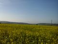
The trip led me35 KM through the upper rhine valley and for the remaining 40 Km through the hills of the Kraichgau. When I reached the Kraichgau in Bruchsal, the sun came through the foggy clouds and the view over the roaring hills, colored by the leaves of the trees and the sun on all that was marvelous. But after a while I got really tired and had to make a short break (and eat something). I found a little chapel on a hill and rested there before I continued. After 15 more KM (mostly upwards) I entered some vineyards and was rewarded by a wonderful view over a small village, two hot-air ballons driving over the landscape and a hashpoint placed in front of me, just 6 m from the path, decorated with some beautiful flowers.
I took another break, did what I had to do (just some pictures, no mark) and continued for the last 10 KM to Pforzheim. With two more hills to there I needed 45 minutes to get there, and then it took me 2 more hours to get back to Speyer by train (could have been 1.16 h, if I would have reached the station at 15:30, but that was obviously to ambitious. Anyway, hashing gave me just another wonderful day out.
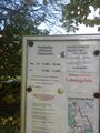
Tracklog
Photos
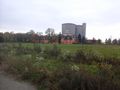
I've been here but have never found the eremitage. Well, it' sstill hard to find on the foto.
Forbidden path. But not during the weekend
You can see the power plant Karlsruhe at the horizon
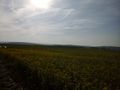
And fron the same place you see the telecommunication tower Hornisgrinde in the black forest
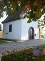
Break chapel
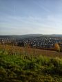
Keltern and two balloons
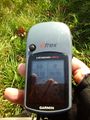
first proof
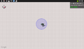
second proof
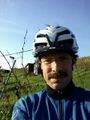
obligatory
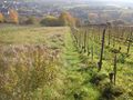
view from the hash
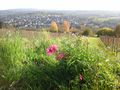
hashflower
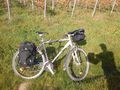
hashbike


Achievements
DODO earned the Land geohash achievement
|
DODO earned the Consecutive geohash achievement
|
DODO earned the Bicycle geohash achievement
|