Difference between revisions of "2014-11-03 59 18"
imported>Odberger m (→Plans) |
imported>GeorgDerReisende (success) |
||
| Line 46: | Line 46: | ||
| − | + | [[Category:Expeditions]] | |
| − | |||
| − | [[Category: | ||
| − | + | [[Category:Expeditions with photos]] | |
| − | |||
| − | |||
| − | |||
| − | [[Category: | ||
| − | |||
| − | |||
| − | |||
| − | |||
| − | |||
| − | |||
| − | |||
| − | |||
| − | |||
| − | |||
[[Category:Coordinates reached]] | [[Category:Coordinates reached]] | ||
| − | |||
| − | |||
| − | |||
| − | |||
| − | |||
| − | |||
| − | |||
| − | |||
| − | |||
| − | |||
| − | |||
| − | |||
| − | |||
| − | |||
| − | |||
| − | |||
Revision as of 14:51, 3 November 2014
| Mon 3 Nov 2014 in 59,18: 59.3296737, 18.1449406 geohashing.info google osm bing/os kml crox |
Location
Gärdet, which is a park like area north east of center of Stockholm, Sweden
Participants
Plans
This will be my second Geohash ever. I have started to check the daily geohash to see if it's nearby. This one is only 10km from my work and I'll visit the place during lunch
Expedition
During lunch I took the car and parked near the coordinates of today. After a short walk for about 150m I found myself standing on Ground Zero. I put up info about geohashing on the nearest tree and I took a selfie with that tree in the background. Then I continued to pick upp my "geocache for the day" which was about 140m away from GZ. I know that I was a bit early as the standard meeting time is 16:00 (4 pm), but today I'm busy at work then. I hope that somebody else will be there at that time.
Tracklog
Photos
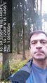
Me visiting today's Geohash. @59.3297,18.1450
