Difference between revisions of "2014-11-08 49 8"
imported>Q-Owl |
imported>Q-Owl |
||
| Line 1: | Line 1: | ||
| − | [[Image:2014-11-08 49 8 grin.jpg | Smile|thumb|left]] | + | [[Image:2014-11-08 49 8 grin.jpg | Smile|thumb|left]] {{meetup graticule |
| − | {{meetup graticule | ||
| lat=49 | | lat=49 | ||
| lon=8 | | lon=8 | ||
| date=2014-11-08 | | date=2014-11-08 | ||
| − | }} | + | }}__NOTOC__ |
| − | __NOTOC__ | ||
== Location == | == Location == | ||
| Line 30: | Line 28: | ||
== Expedition == | == Expedition == | ||
| − | We drove to the Guldenklinger Hoehe, parked the car and found [http://coord.info/GC5DZGT GC5DZGT] within five minutes. We met two other geocachers | + | We drove to the Guldenklinger Hoehe, parked the car and found [http://coord.info/GC5DZGT GC5DZGT] within five minutes. We met two other geocachers and told them a little bit about geohashing. |
| + | |||
Then we walked along the edge of the forest on nice trails up the hill and found [http://opencaching.de/OCBE42 OCBE42] (585 m distance to the hash). The weather was wounderful and warm. But we went too fast for Q-Owla and she decided to stay at/on a bench with a nice view over the valley. | Then we walked along the edge of the forest on nice trails up the hill and found [http://opencaching.de/OCBE42 OCBE42] (585 m distance to the hash). The weather was wounderful and warm. But we went too fast for Q-Owla and she decided to stay at/on a bench with a nice view over the valley. | ||
| Line 48: | Line 47: | ||
Image:2014-11-08 49 8 east.jpg | east | Image:2014-11-08 49 8 east.jpg | east | ||
Image:2014-11-08 49 8 grin.jpg | smile | Image:2014-11-08 49 8 grin.jpg | smile | ||
| + | Image:2014-11-08 49 8 happy.jpg | she waited on a bench under big trees | ||
</gallery> | </gallery> | ||
<!-- | <!-- | ||
Revision as of 22:16, 8 November 2014

| Sat 8 Nov 2014 in 49,8: 49.6577619, 8.7020348 geohashing.info google osm bing/os kml crox |
Location
In the Odenwald east of Heppenheim, near Mittershausen.
Participants
Plan
Drive by car near the hash area, walk to the hashpoint, take some photos find some geocaches and return to the car.
Nearest geocache: GC2Y643 360 m as a deer runs / 1.5 km walk.
Nearest points to start the walk:
- N 49° 39.475 E 008° 42.840 Mittershausen: 1.5 km
- N 49° 38.980 E 008° 42.630 Guldenklinger Hoehe near the B460 (location of GC5DZGT): 1.7 km
- N 49° 40.137 E 008° 41.345 Ober-Hambach (nice walk): 2 km
I don't know whether I will have time to visit the hashpoint. If yes, I try to reach it between 15:30 and 16:00.
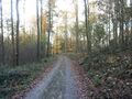
Expedition
We drove to the Guldenklinger Hoehe, parked the car and found GC5DZGT within five minutes. We met two other geocachers and told them a little bit about geohashing.
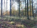
Then we walked along the edge of the forest on nice trails up the hill and found OCBE42 (585 m distance to the hash). The weather was wounderful and warm. But we went too fast for Q-Owla and she decided to stay at/on a bench with a nice view over the valley.
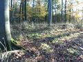
I reached the hashpoint at 15:45, marked it with crossed branches, took some photos, smiled and went back to Q-Owla. On our way back to the car we found some nice mushrooms: boletus edulis (Steinpilz), parasol mushroom (Riesenschirmling), bay bolete (Maronenröhrling)
On the way home we solved one of the Safari Caches: OC1176D
Photos
track to the hp
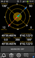
proof
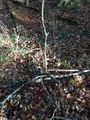
marked hashpoint
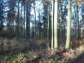
north
west
south
east

smile
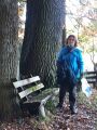
she waited on a bench under big trees


Achievements / Honorable Mention
Q-Owl earned the Land geohash achievement
|