Difference between revisions of "2014-11-12 51 9"
imported>GeorgDerReisende |
imported>GeorgDerReisende (expedition report for Oberbeisheim) |
||
| Line 1: | Line 1: | ||
| − | |||
| − | |||
| − | |||
| − | |||
| − | |||
| − | |||
| − | |||
| − | |||
| − | |||
| − | |||
{{meetup graticule | {{meetup graticule | ||
| lat=51 | | lat=51 | ||
| Line 18: | Line 8: | ||
__NOTOC__ | __NOTOC__ | ||
== Location == | == Location == | ||
| − | + | ||
| + | The hash lay on the western side of the Schneidelwald, south of Oberbeisheim. | ||
== Participants == | == Participants == | ||
| − | + | ||
| − | + | [[User:GeorgDerReisende|GeorgDerReisende]] | |
== Plans == | == Plans == | ||
| − | + | ||
| + | Hitchhiking and walking. | ||
== Expedition == | == Expedition == | ||
| − | + | ||
| + | I left home at 8 o'clock and started to hitchhike at 9 o'clock. After nearly two hours I got a lift to the service station ''Hasselberg''. From there I walked to the hash. On the way to the hash I found five geocaches and on the way afterwards I found four geocaches. The nearest geocache was GC4G514, only 74 meters away. The hash was inside a field of young beeches. On the way out I found a traffic sign of a water protection area in midst the forest. | ||
== Tracklog == | == Tracklog == | ||
| Line 34: | Line 27: | ||
== Photos == | == Photos == | ||
| − | |||
| − | |||
| − | |||
<gallery perrow="5"> | <gallery perrow="5"> | ||
| − | Image:2014-11-12 51 9 GeorgDerReisende 0025.jpg | | + | Image:2014-11-12 51 9 GeorgDerReisende 0025.jpg | the geocache GC4G514 |
| − | Image:2014-11-12 51 9 GeorgDerReisende 0027.jpg | | + | Image:2014-11-12 51 9 GeorgDerReisende 0027.jpg | proof of log |
| − | Image:2014-11-12 51 9 GeorgDerReisende 0028.jpg | | + | Image:2014-11-12 51 9 GeorgDerReisende 0028.jpg | view to the hash from the geocache |
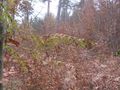
| − | Image:2014-11-12 51 9 GeorgDerReisende 0031.jpg | | + | Image:2014-11-12 51 9 GeorgDerReisende 0031.jpg | 60 meters right from the way |
| − | Image:2014-11-12 51 9 GeorgDerReisende 0036.jpg | | + | Image:2014-11-12 51 9 GeorgDerReisende 0036.jpg | proof |
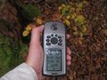
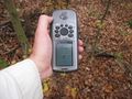
| − | Image:2014-11-12 51 9 GeorgDerReisende 0037.jpg | | + | Image:2014-11-12 51 9 GeorgDerReisende 0037.jpg | proof of dance |
| − | Image:2014-11-12 51 9 GeorgDerReisende 0038.jpg | | + | Image:2014-11-12 51 9 GeorgDerReisende 0038.jpg | proof of grin |
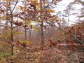
| − | Image:2014-11-12 51 9 GeorgDerReisende 0039.jpg | | + | Image:2014-11-12 51 9 GeorgDerReisende 0039.jpg | view to the east |
| − | Image:2014-11-12 51 9 GeorgDerReisende 0040.jpg | | + | Image:2014-11-12 51 9 GeorgDerReisende 0040.jpg | view to the north |
| − | Image:2014-11-12 51 9 GeorgDerReisende 0041.jpg | | + | Image:2014-11-12 51 9 GeorgDerReisende 0041.jpg | view to the west |
| − | Image:2014-11-12 51 9 GeorgDerReisende 0042.jpg | | + | Image:2014-11-12 51 9 GeorgDerReisende 0042.jpg | view to the south |
| − | Image:2014-11-12 51 9 GeorgDerReisende 0126.jpg | | + | Image:2014-11-12 51 9 GeorgDerReisende 0033.jpg | water protection in the forest |
| − | Image:2014-11-12 51 9 GeorgDerReisende 0138.jpg | | + | Image:2014-11-12 51 9 GeorgDerReisende 0126.jpg | main street of Oberbeisheim, here down or there up? |
| + | Image:2014-11-12 51 9 GeorgDerReisende 0138.jpg | view to Oberbeisheim | ||
</gallery> | </gallery> | ||
| Line 57: | Line 48: | ||
<!-- Add any achievement ribbons you earned below, or remove this section --> | <!-- Add any achievement ribbons you earned below, or remove this section --> | ||
| + | {{Thumbs Up | latitude = 51 | longitude = 9 | date = 2014-11-12 | name = GeorgDerReisende }} | ||
[[Category:Expeditions]] | [[Category:Expeditions]] | ||
Revision as of 18:51, 13 November 2014
| Wed 12 Nov 2014 in 51,9: 51.0108316, 9.4917740 geohashing.info google osm bing/os kml crox |
Location
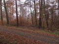
The hash lay on the western side of the Schneidelwald, south of Oberbeisheim.
Participants
Plans
Hitchhiking and walking.
Expedition
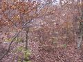
I left home at 8 o'clock and started to hitchhike at 9 o'clock. After nearly two hours I got a lift to the service station Hasselberg. From there I walked to the hash. On the way to the hash I found five geocaches and on the way afterwards I found four geocaches. The nearest geocache was GC4G514, only 74 meters away. The hash was inside a field of young beeches. On the way out I found a traffic sign of a water protection area in midst the forest.
Tracklog
Photos
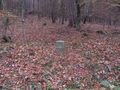
the geocache GC4G514
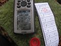
proof of log
view to the hash from the geocache
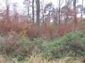
60 meters right from the way
proof
proof of dance

proof of grin

view to the east
view to the north
view to the west
view to the south
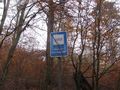
water protection in the forest
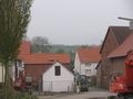
main street of Oberbeisheim, here down or there up?
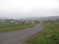
view to Oberbeisheim


Achievements
GeorgDerReisende earned the Thumbs Up Geohash Achievement
|