Difference between revisions of "2014-11-29 43 -121"
From Geohashing
imported>Frogman (→Location) |
imported>FippeBot m (Location) |
||
| (4 intermediate revisions by one other user not shown) | |||
| Line 21: | Line 21: | ||
== Participants == | == Participants == | ||
| − | + | *[[User:Frogman|Frogman]] | |
| − | + | *[[User:Benture|Benture]] | |
| + | *Maggie | ||
| + | *John | ||
| + | *Daisy | ||
== Plans == | == Plans == | ||
| Line 28: | Line 31: | ||
== Expedition == | == Expedition == | ||
| − | + | We drove out a gravel road until we could get no closer. There was an off-road vehicle trail that lead straight towards the hashpoint, so it was an easy walk in! Afterwards, we walked up onto a ridge to get some great views. It was also really windy, though - no trees out there! | |
== Tracklog == | == Tracklog == | ||
| Line 38: | Line 41: | ||
--> | --> | ||
<gallery perrow="5"> | <gallery perrow="5"> | ||
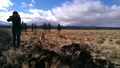
| + | File:2014-11-29 43 -121 1.jpg | On the way! | ||
| + | File:2014-11-29 43 -121 2.jpg | This is the easiest trail. EVER. | ||
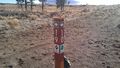
| + | File:2014-11-29 43 -121 3.jpg | Recalibrating GPS | ||
| + | File:2014-11-29 43 -121 4.jpg | You need to make sure to keep your tree charged. | ||
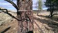
| + | File:2014-11-29 43 -121 5.jpg | This tree is at the hashpoint. | ||
| + | File:2014-11-29 43 -121 6.jpg | Goofy grins! | ||
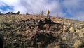
| + | File:2014-11-29 43 -121 7.jpg | Climbing up the ridge. | ||
| + | File:2014-11-29 43 -121 8.jpg | View to the east. | ||
| + | File:2014-11-29 43 -121 9.jpg | Lookin' good! | ||
| + | File:2014-11-29 43 -121 10.jpg | View to the west; lots of wind! | ||
</gallery> | </gallery> | ||
| Line 45: | Line 58: | ||
| − | |||
| − | |||
| − | |||
| − | |||
| − | |||
| − | |||
| − | |||
| − | |||
| − | |||
| − | |||
| − | |||
| − | |||
[[Category:Expeditions]] | [[Category:Expeditions]] | ||
| − | |||
[[Category:Expeditions with photos]] | [[Category:Expeditions with photos]] | ||
| − | |||
| − | |||
| − | |||
| − | |||
| − | |||
[[Category:Coordinates reached]] | [[Category:Coordinates reached]] | ||
| − | + | {{location|US|OR|DE}} | |
| − | |||
| − | |||
| − | |||
| − | |||
| − | |||
| − | |||
| − | |||
| − | |||
| − | |||
| − | |||
| − | |||
| − | |||
| − | |||
| − | |||
| − | |||
| − | |||
| − | |||
Latest revision as of 02:05, 15 August 2019
| Sat 29 Nov 2014 in 43,-121: 43.8721692, -121.0986994 geohashing.info google osm bing/os kml crox |
Location
A grove of trees near a network of off-road vehicle trails in Eastern Oregon.
Participants
Plans
Expedition
We drove out a gravel road until we could get no closer. There was an off-road vehicle trail that lead straight towards the hashpoint, so it was an easy walk in! Afterwards, we walked up onto a ridge to get some great views. It was also really windy, though - no trees out there!
Tracklog
Photos
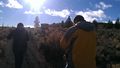
On the way!
This is the easiest trail. EVER.
Recalibrating GPS
You need to make sure to keep your tree charged.
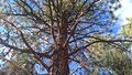
This tree is at the hashpoint.

Goofy grins!
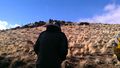
Climbing up the ridge.
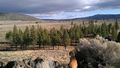
View to the east.
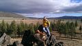
Lookin' good!
View to the west; lots of wind!


