Difference between revisions of "2014-12-13 60 22"
imported>Suurnesu ([live picture] Juu) |
imported>FippeBot m (Location) |
||
| (4 intermediate revisions by one other user not shown) | |||
| Line 18: | Line 18: | ||
__NOTOC__ | __NOTOC__ | ||
== Location == | == Location == | ||
| − | + | In industrial area "Itäharju" in Turku. Only 10 meters from the street. | |
== Participants == | == Participants == | ||
| − | + | [[User:Suurnesu|Suurnesu]] | |
| − | |||
| − | |||
| − | |||
== Expedition == | == Expedition == | ||
<!-- how it all turned out. your narrative goes here. --> | <!-- how it all turned out. your narrative goes here. --> | ||
| + | I noticed that hashpoint is quite close to my home. In the evening I decided to place a visit there. I left my car nearby and walked towards zero. I had to leave pedestrian way some 20 meters before ground zero and take a short walk in forest. I did some zig-zag before my geohashing app showde less than 1 meter distance. | ||
| + | The hashpoint was close to ex-hardware store K-Rauta. I used to go there quite often before it was closed and moved some 500 meters towards Skanssi. The hashpoint was at the edge of a forest which has some interesting history. There are old bunkers on top of the hill. I have visited them several times because of geocaching. | ||
| − | + | -- [[User:Suurnesu|suurnesu]] ([[User talk:Suurnesu|talk]]) [http://www.openstreetmap.org/?lat=60.44197990&lon=22.31616480&zoom=16&layers=B000FTF @60.4420,22.3162] 14:34, 13 December 2014 (EST) | |
| − | |||
| − | |||
== Photos == | == Photos == | ||
| Line 41: | Line 38: | ||
<gallery perrow="5"> | <gallery perrow="5"> | ||
| − | Image:2014-12-13_60_22_Suurnesu_1418499301269.jpg | | + | Image:2014-12-13_60_22_Suurnesu_1418499301269.jpg | Happy geohasher at zero point |
| − | |||
| − | + | Image:2014-12-13_60_22_Suurnesu_1418499357618.jpg | Some snow on the ground | |
| − | |||
| − | |||
| + | Image:2014-12-13_60_22_Suurnesu_1418499327077.jpg | View from the hashpoint | ||
| − | + | Image:2014-12-13_60_22_Suurnesu_1418499572998.jpg | Closed hardware store | |
| − | + | </gallery> | |
| − | |||
| − | |||
| − | |||
| − | |||
| − | |||
| − | |||
| − | |||
| − | |||
[[Category:Expeditions]] | [[Category:Expeditions]] | ||
| − | + | [[Category:Expeditions with photos]] | |
| − | [[Category:Expeditions with photos]] | ||
| − | |||
| − | |||
| − | |||
| − | |||
| − | |||
[[Category:Coordinates reached]] | [[Category:Coordinates reached]] | ||
| − | + | {{location|FI|19}} | |
| − | |||
| − | |||
| − | |||
| − | |||
| − | |||
| − | |||
| − | |||
| − | |||
| − | |||
| − | |||
| − | |||
| − | |||
| − | |||
| − | |||
| − | |||
| − | |||
| − | |||
Latest revision as of 02:11, 15 August 2019
| Sat 13 Dec 2014 in 60,22: 60.4419590, 22.3161601 geohashing.info google osm bing/os kml crox |
Location
In industrial area "Itäharju" in Turku. Only 10 meters from the street.
Participants
Expedition
I noticed that hashpoint is quite close to my home. In the evening I decided to place a visit there. I left my car nearby and walked towards zero. I had to leave pedestrian way some 20 meters before ground zero and take a short walk in forest. I did some zig-zag before my geohashing app showde less than 1 meter distance.
The hashpoint was close to ex-hardware store K-Rauta. I used to go there quite often before it was closed and moved some 500 meters towards Skanssi. The hashpoint was at the edge of a forest which has some interesting history. There are old bunkers on top of the hill. I have visited them several times because of geocaching.
-- suurnesu (talk) @60.4420,22.3162 14:34, 13 December 2014 (EST)
Photos

Happy geohasher at zero point
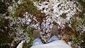
Some snow on the ground
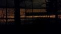
View from the hashpoint
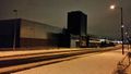
Closed hardware store


