Difference between revisions of "2014-12-15 41 -88"
From Geohashing
imported>Buttercup (Created page with "<!-- If you did not specify these parameters in the template, please substitute appropriate values for IMAGE, LAT, LON, and DATE (YYYY-MM-DD format) Remove this section if y...") |
imported>FippeBot m (Location) |
||
| (2 intermediate revisions by 2 users not shown) | |||
| Line 8: | Line 8: | ||
{{meetup graticule | {{meetup graticule | ||
| lat=41 | | lat=41 | ||
| − | | lon=- | + | | lon=-88 |
| date=2014-12-15 | | date=2014-12-15 | ||
}} | }} | ||
| Line 52: | Line 52: | ||
[[Category:Expeditions]] | [[Category:Expeditions]] | ||
| − | |||
[[Category:Expeditions with photos]] | [[Category:Expeditions with photos]] | ||
| − | + | [[Category:Coordinates reached]] | |
| − | [[Category:Coordinates | + | {{location|US|IL|DU}} |
| − | |||
Latest revision as of 02:11, 15 August 2019
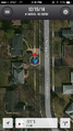
| Mon 15 Dec 2014 in 41,-88: 41.8425157, -88.1082021 geohashing.info google osm bing/os kml crox |
Location
On my way home from work in a neighborhood off the main road.
Participants
Plans
I didn't check where the hash was until I got to work. Conveniently it was right on the way home!
Expedition
It went just as planned. Luckily it wasn't very rainy when I got there.
Photos
GPS

Success!


Achievements
Buttercup earned the Land geohash achievement
|