Difference between revisions of "2014-12-18 59 17"
imported>Odberger ([live picture] Today's Geohash is only a couple of kilometres from my work [http://www.openstreetmap.org/?lat=59.35183995&lon=17.98270622&zoom=16&layers=B000FTF @59.3518,17.9827]) |
imported>FippeBot m (Location) |
||
| (6 intermediate revisions by 2 users not shown) | |||
| Line 18: | Line 18: | ||
__NOTOC__ | __NOTOC__ | ||
== Location == | == Location == | ||
| − | + | Solna, Stockholm, Sweden. Solna is a suburb about 7-8km north of Stockholm city. | |
== Participants == | == Participants == | ||
| − | + | [[User:Odberger|Odberger]] | |
| − | |||
== Plans == | == Plans == | ||
| − | + | I look at today's Geohash every morning and today I saw that it was located only 1km from work. Perfect trip for my lunch break! | |
== Expedition == | == Expedition == | ||
| − | + | I took the car to the Geohash even if it's only 1km for several reasons. First I had to continue to take "todays Goecache" and second, it was so slippery with rain on icy pavement. I had problems getting the car to stop when I was about to park like 20m from GZ. Then I walked, like Bambi on ice, the last meters to the Geohash. It was located just outside of an apartment building and I put up the sign (with magnets) on a pole. Then I took the pictures before adding the info to Wiki. Then I continued to the Geocache. | |
== Tracklog == | == Tracklog == | ||
| Line 38: | Line 37: | ||
--> | --> | ||
<gallery perrow="5"> | <gallery perrow="5"> | ||
| − | + | ||
Image:2014-12-18_59_17_Odberger_1418896759298.jpg | Today's Geohash is only a couple of kilometres from my work [http://www.openstreetmap.org/?lat=59.35183995&lon=17.98270622&zoom=16&layers=B000FTF @59.3518,17.9827] | Image:2014-12-18_59_17_Odberger_1418896759298.jpg | Today's Geohash is only a couple of kilometres from my work [http://www.openstreetmap.org/?lat=59.35183995&lon=17.98270622&zoom=16&layers=B000FTF @59.3518,17.9827] | ||
| + | Image:2014-12-18_59_17_Odberger_1418896759298b.jpg | Another angle [http://www.openstreetmap.org/?lat=59.35183995&lon=17.98270622&zoom=16&layers=B000FTF @59.3518,17.9827] | ||
</gallery> | </gallery> | ||
| Line 47: | Line 47: | ||
| − | |||
| − | |||
| − | |||
| − | |||
| − | |||
| − | |||
| − | |||
| − | |||
| − | |||
| − | |||
| − | |||
| − | |||
[[Category:Expeditions]] | [[Category:Expeditions]] | ||
| − | |||
[[Category:Expeditions with photos]] | [[Category:Expeditions with photos]] | ||
| − | |||
| − | |||
| − | |||
| − | |||
| − | |||
[[Category:Coordinates reached]] | [[Category:Coordinates reached]] | ||
| − | + | {{location|SE|AB}} | |
| − | |||
| − | |||
| − | |||
| − | |||
| − | |||
| − | |||
| − | |||
| − | |||
| − | |||
| − | |||
| − | |||
| − | |||
| − | |||
| − | |||
| − | |||
| − | |||
| − | |||
Latest revision as of 02:12, 15 August 2019
| Thu 18 Dec 2014 in 59,17: 59.3518410, 17.9827087 geohashing.info google osm bing/os kml crox |
Location
Solna, Stockholm, Sweden. Solna is a suburb about 7-8km north of Stockholm city.
Participants
Plans
I look at today's Geohash every morning and today I saw that it was located only 1km from work. Perfect trip for my lunch break!
Expedition
I took the car to the Geohash even if it's only 1km for several reasons. First I had to continue to take "todays Goecache" and second, it was so slippery with rain on icy pavement. I had problems getting the car to stop when I was about to park like 20m from GZ. Then I walked, like Bambi on ice, the last meters to the Geohash. It was located just outside of an apartment building and I put up the sign (with magnets) on a pole. Then I took the pictures before adding the info to Wiki. Then I continued to the Geocache.
Tracklog
Photos
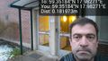
Today's Geohash is only a couple of kilometres from my work @59.3518,17.9827

Another angle @59.3518,17.9827

