Difference between revisions of "2014-12-21 49 8"
imported>DODO (→Participants) |
imported>FippeBot m (Location) |
||
| (5 intermediate revisions by one other user not shown) | |||
| Line 28: | Line 28: | ||
== Plans == | == Plans == | ||
<!-- what were the original plans --> | <!-- what were the original plans --> | ||
| + | I have to go to the rowing club in Mannheim-Rheinau anyway, and todays hashpoint is just 7 KM away from there, so I'll have a look. Hope to arrive at 4pm. | ||
== Expedition == | == Expedition == | ||
<!-- how it all turned out. your narrative goes here. --> | <!-- how it all turned out. your narrative goes here. --> | ||
| + | Well, it should have been easy, drive near the hash, walk 3 KM to the point and back and continue to the rowing club. But it wasn't. | ||
| + | |||
| + | First of all I decided to let my car near the Rheingoldhalle, a concert hall of the city of Mannheim. So I had an additional KM to walk anyway. Then I missed the right way to the hash. The Reisinsel is a nature reserve nowadays and is completely fenced, with only five gates. And there was none of them where I want to enter. So another additional KM had to be walked. But then I found the right path that brought me 60 m to the hash. There was a thicket of nettles and blackberries, but it seems to be doable. So I left the path and entered the copse. The thicket gets worse and worse the closer I come to my aim, so dancing was really uncomfortable. GPS accuracy was bad, but I got a 3. Good enough for me. | ||
| + | |||
| + | On my way back I got lost and had another detour. So all in all I walked 7,5 KM and needed 80 minutes instead of 30. All in all, a lot of fun again. I came late to the christmas party at the rowing club, but there were still some Glühwein and some sausages and some cake. And I had a success to celebrate. | ||
== Tracklog == | == Tracklog == | ||
<!-- if your GPS device keeps a log, you may post a link here --> | <!-- if your GPS device keeps a log, you may post a link here --> | ||
| + | [http://www.gpsies.com/map.do?fileId=ffrylcwbdeoivsed 35 KM by car (instead of 25 KM), 7,5 KM by foot] | ||
== Photos == | == Photos == | ||
| Line 40: | Line 47: | ||
--> | --> | ||
<gallery perrow="5"> | <gallery perrow="5"> | ||
| + | Image:2014-12-21_49_8-4.jpg | my first visit at the river rhine | ||
| + | Image:2014-12-21_49_8-2.jpg | the entrance to the natural reservat | ||
| + | Image:2014-12-21_49_8-1.jpg | 60 m in there | ||
| + | Image:2014-12-21_49_8-5.jpg | where the thicket got denser... | ||
| + | Image:2014-12-21_49_8-6.jpg | at these dead trees | ||
| + | Image:2014-12-21_49_8-7.jpg | is the profane hashpoint | ||
| + | Image:2014-12-21_49_8-8.png | another proof | ||
| + | Image:2014-12-21_49_8-9.jpg | and a lucky hasher | ||
| + | Image:2014-12-21_49_8-3.jpg | you can see a ship through the forest | ||
</gallery> | </gallery> | ||
| Line 45: | Line 61: | ||
{{#vardefine:ribbonwidth|800px}} | {{#vardefine:ribbonwidth|800px}} | ||
<!-- Add any achievement ribbons you earned below, or remove this section --> | <!-- Add any achievement ribbons you earned below, or remove this section --> | ||
| + | {{land geohash | ||
| + | | latitude = 49 | ||
| + | | longitude = 8 | ||
| + | | date = 2014-12-21 | ||
| + | | name = DODO | ||
| + | }} | ||
| − | |||
| − | |||
| − | |||
| − | |||
| − | |||
| − | |||
| − | |||
| − | |||
| − | |||
| − | |||
| − | |||
| − | |||
| − | |||
[[Category:Expeditions]] | [[Category:Expeditions]] | ||
| − | |||
[[Category:Expeditions with photos]] | [[Category:Expeditions with photos]] | ||
| − | |||
| − | |||
| − | |||
| − | |||
| − | |||
[[Category:Coordinates reached]] | [[Category:Coordinates reached]] | ||
| − | + | {{location|DE|BW|MA}} | |
| − | |||
| − | |||
| − | |||
| − | |||
| − | |||
| − | |||
| − | |||
| − | |||
| − | |||
| − | |||
| − | |||
| − | |||
| − | |||
| − | |||
| − | |||
| − | |||
| − | |||
Latest revision as of 02:14, 15 August 2019
| Sun 21 Dec 2014 in 49,8: 49.4517469, 8.4444080 geohashing.info google osm bing/os kml crox |
Location
In the Landschaftsschutzgebiet (landscape protection area) Reißinsel near the bank of the river rhine.
Participants
Plans
I have to go to the rowing club in Mannheim-Rheinau anyway, and todays hashpoint is just 7 KM away from there, so I'll have a look. Hope to arrive at 4pm.
Expedition
Well, it should have been easy, drive near the hash, walk 3 KM to the point and back and continue to the rowing club. But it wasn't.
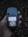
First of all I decided to let my car near the Rheingoldhalle, a concert hall of the city of Mannheim. So I had an additional KM to walk anyway. Then I missed the right way to the hash. The Reisinsel is a nature reserve nowadays and is completely fenced, with only five gates. And there was none of them where I want to enter. So another additional KM had to be walked. But then I found the right path that brought me 60 m to the hash. There was a thicket of nettles and blackberries, but it seems to be doable. So I left the path and entered the copse. The thicket gets worse and worse the closer I come to my aim, so dancing was really uncomfortable. GPS accuracy was bad, but I got a 3. Good enough for me.
On my way back I got lost and had another detour. So all in all I walked 7,5 KM and needed 80 minutes instead of 30. All in all, a lot of fun again. I came late to the christmas party at the rowing club, but there were still some Glühwein and some sausages and some cake. And I had a success to celebrate.
Tracklog
35 KM by car (instead of 25 KM), 7,5 KM by foot
Photos
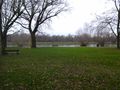
my first visit at the river rhine
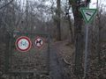
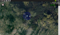
the entrance to the natural reservat
60 m in there
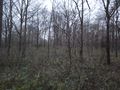
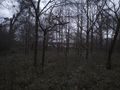
where the thicket got denser...
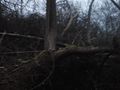
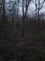
at these dead trees
is the profane hashpoint
another proof
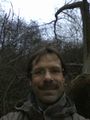
and a lucky hasher
you can see a ship through the forest


Achievements
DODO earned the Land geohash achievement
|