Difference between revisions of "2014-12-28 49 8"
imported>DODO (→Plans) |
imported>FippeBot m (Location) |
||
| (5 intermediate revisions by one other user not shown) | |||
| Line 28: | Line 28: | ||
== Plans == | == Plans == | ||
<!-- what were the original plans --> | <!-- what were the original plans --> | ||
| − | It was snowing all night long and as most of the snow has melted away in Speyer, I was sure, there would still be a lot of it outside the Rhine valley. The hash was much to far away to go there by bike in the cold, and I don't want to drive so far by car only for geohashing. But I love to visit the monastery in Maulbronn especially around christmas, so lets see, what I can do with that. | + | It was snowing all night long and as most of the snow has melted away in Speyer, I was sure, there would still be a lot of it outside the Rhine valley. The hash was much to far away to go there by bike in the cold, and I don't want to drive so far by car only for geohashing. But I love to visit the monastery in Maulbronn especially around christmas, so lets see, what I can do with that: how about driving to Bretten near the hash and walk to Maulbronn. I'm totally fine to drive 60KM to do a 25 KM walk :-) |
== Expedition == | == Expedition == | ||
<!-- how it all turned out. your narrative goes here. --> | <!-- how it all turned out. your narrative goes here. --> | ||
| + | The drive to Bretten was rather uneventful. The thermometer in the car shows -2ºC and so qualifies me for a frozen gh-achievement. I left the car at a local shopping center. As the center was closed on sunday there was plenty of free space. From here it was just a KM to walk to the hash. As I had hoped there was a lot of snow and the landscape was great. As I was on a field I had good gps-reception and so I even reached a 0. Then I tried to build a snowman, what appears to be a hard job, as the snow was very dry, and not adhesive at all. So I couldn't build snowballs that were bigger than I could press together with my hands, what leads to a very small snowman. Anyway, it should suffice as a mark to following hashers. | ||
| + | |||
| + | And then I started to walk through a german winter wonderland. After two and a half hours I reached the UNESCO world heritage site Maulbronn; on my way I followed the so called "Eppinger Linie", a line of defense from the late 17. century, which consists mostly of dense cops. I took some photos, ate some cake I brought with me in a place called paradise and walked back. On my way to Bretten I met some strange kings and found the birth house of Doctor Faustus in Knittlingen. An hour later I reached my car again after 4 1/2 hours and 26 KM of walking, very tired but also very pleased. | ||
== Tracklog == | == Tracklog == | ||
<!-- if your GPS device keeps a log, you may post a link here --> | <!-- if your GPS device keeps a log, you may post a link here --> | ||
| + | [https://www.komoot.de/tour/4134377 26 KM walk (and additional 120 KM by car)] | ||
== Photos == | == Photos == | ||
| Line 40: | Line 44: | ||
Image:2012-##-## ## ## Alpha.jpg | Witty Comment | Image:2012-##-## ## ## Alpha.jpg | Witty Comment | ||
--> | --> | ||
| − | <gallery perrow=" | + | <gallery perrow="6"> |
| + | Image:2014-12-28_49_8-1.jpg |cold | ||
| + | Image:2014-12-28_49_8-2.jpg |proof | ||
| + | Image:2014-12-28_49_8-17.png |another proof | ||
| + | Image:2014-12-28_49_8-3.jpg |my tiny snowman | ||
| + | Image:2014-12-28_49_8-4.jpg |view from the hash to the north | ||
| + | Image:2014-12-28_49_8-5.jpg |view from the hash to Bretten | ||
| + | Image:2014-12-28_49_8-6.jpg |a german... | ||
| + | Image:2014-12-28_49_8-7.jpg |...winter... | ||
| + | Image:2014-12-28_49_8-9.jpg |...wonderland (even if the way is very wet) | ||
| + | Image:2014-12-28_49_8-8.jpg |a creepy detail: the former gibbet place (used until 1822) | ||
| + | Image:2014-12-28_49_8-10.jpg |thats how the Eppinger Linie might have looked like | ||
| + | Image:2014-12-28_49_8-11.jpg |after 2h 20m the first view to Maulbronn | ||
| + | Image:2014-12-28_49_8-12.jpg |inside the monastery | ||
| + | Image:2014-12-28_49_8-13.jpg |the paradise | ||
| + | Image:2014-12-28_49_8-14.jpg |three holy kings (and one mother) | ||
| + | Image:2014-12-28_49_8-15.jpg |Doctor Faustus was born here | ||
| + | Image:2014-12-28_49_8-16.jpg |the town hall of Knittlingen. Nowadays a Faust-Museum | ||
</gallery> | </gallery> | ||
| Line 47: | Line 68: | ||
<!-- Add any achievement ribbons you earned below, or remove this section --> | <!-- Add any achievement ribbons you earned below, or remove this section --> | ||
| + | {{land geohash | ||
| + | | latitude = 49 | ||
| + | | longitude = 8 | ||
| + | | date = 2014-12-28 | ||
| + | | name = [[User:DODO|DODO]] | ||
| + | }} | ||
| + | {{Frozen Geohash | ||
| + | | latitude = 49 | ||
| + | | longitude = 8 | ||
| + | | date = 2014-12-28 | ||
| + | | name = [[User:DODO|DODO]] | ||
| + | }} | ||
| + | {{snowman geohash | ||
| + | | latitude = 49 | ||
| + | | longitude = 8 | ||
| + | | date = 2014-12-28 | name = DODO | ||
| + | | honourable = yes | ||
| + | }} | ||
| − | |||
| − | |||
| − | |||
| − | |||
| − | |||
| − | |||
| − | |||
| − | |||
| − | |||
| − | |||
| − | |||
| − | |||
[[Category:Expeditions]] | [[Category:Expeditions]] | ||
| − | |||
[[Category:Expeditions with photos]] | [[Category:Expeditions with photos]] | ||
| − | |||
| − | |||
| − | |||
| − | |||
| − | |||
[[Category:Coordinates reached]] | [[Category:Coordinates reached]] | ||
| − | + | {{location|DE|BW|KA}} | |
| − | |||
| − | |||
| − | |||
| − | |||
| − | |||
| − | |||
| − | |||
| − | |||
| − | |||
| − | |||
| − | |||
| − | |||
| − | |||
| − | |||
| − | |||
| − | |||
| − | |||
Latest revision as of 02:16, 15 August 2019
| Sun 28 Dec 2014 in 49,8: 49.0301417, 8.6937423 geohashing.info google osm bing/os kml crox |
Location
On a field next to Bretten
Participants
Plans
It was snowing all night long and as most of the snow has melted away in Speyer, I was sure, there would still be a lot of it outside the Rhine valley. The hash was much to far away to go there by bike in the cold, and I don't want to drive so far by car only for geohashing. But I love to visit the monastery in Maulbronn especially around christmas, so lets see, what I can do with that: how about driving to Bretten near the hash and walk to Maulbronn. I'm totally fine to drive 60KM to do a 25 KM walk :-)
Expedition
The drive to Bretten was rather uneventful. The thermometer in the car shows -2ºC and so qualifies me for a frozen gh-achievement. I left the car at a local shopping center. As the center was closed on sunday there was plenty of free space. From here it was just a KM to walk to the hash. As I had hoped there was a lot of snow and the landscape was great. As I was on a field I had good gps-reception and so I even reached a 0. Then I tried to build a snowman, what appears to be a hard job, as the snow was very dry, and not adhesive at all. So I couldn't build snowballs that were bigger than I could press together with my hands, what leads to a very small snowman. Anyway, it should suffice as a mark to following hashers.
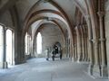
And then I started to walk through a german winter wonderland. After two and a half hours I reached the UNESCO world heritage site Maulbronn; on my way I followed the so called "Eppinger Linie", a line of defense from the late 17. century, which consists mostly of dense cops. I took some photos, ate some cake I brought with me in a place called paradise and walked back. On my way to Bretten I met some strange kings and found the birth house of Doctor Faustus in Knittlingen. An hour later I reached my car again after 4 1/2 hours and 26 KM of walking, very tired but also very pleased.
Tracklog
26 KM walk (and additional 120 KM by car)
Photos
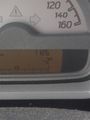
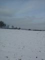
cold
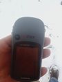
proof
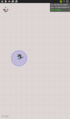
another proof
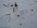
my tiny snowman
view from the hash to the north
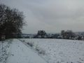
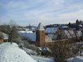
view from the hash to Bretten
a german...
...winter...
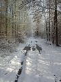
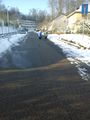
...wonderland (even if the way is very wet)
a creepy detail: the former gibbet place (used until 1822)
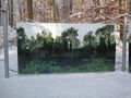
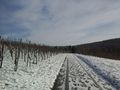
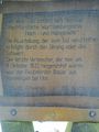
thats how the Eppinger Linie might have looked like
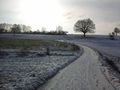
after 2h 20m the first view to Maulbronn
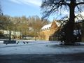
inside the monastery
the paradise
three holy kings (and one mother)
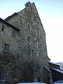
Doctor Faustus was born here
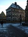
the town hall of Knittlingen. Nowadays a Faust-Museum


Achievements
DODO earned the Land geohash achievement
|

DODO earned the Snowman Geohash Honourable Mention
|