Difference between revisions of "2015-01-01 49 8"
From Geohashing
imported>DODO (→Photos) |
imported>DODO (→Achievements) |
||
| Line 58: | Line 58: | ||
<!-- Add any achievement ribbons you earned below, or remove this section --> | <!-- Add any achievement ribbons you earned below, or remove this section --> | ||
| + | {{land geohash | ||
| − | + | | latitude = 49 | |
| − | + | | longitude = 8 | |
| − | + | | date = 2015-01-01 | |
| + | | name = DODO | ||
| + | }} | ||
| − | + | {{Walk geohash | |
| + | | latitude = 49 | ||
| + | | longitude = 8 | ||
| + | | date = 2015-01-01 | ||
| + | | name = DODO | ||
| + | | distance = 9,3 KM | ||
| + | | image=2015-01-01 49 8-2.jpg | ||
| + | }} | ||
| + | |||
| + | {{Template:Tron | ||
| + | | latitude = 49 | ||
| + | | longitude = 8 | ||
| + | | date = 2015-01-01 | ||
| + | | name = DODO | ||
| + | | possessive = his | ||
| + | | tracklog = http://www.gpsies.com/map.do?fileId=bsqpismwkudpaaap | ||
| + | }} | ||
| − | |||
| − | |||
| − | |||
| − | |||
| − | |||
[[Category:Expeditions]] | [[Category:Expeditions]] | ||
| − | |||
[[Category:Expeditions with photos]] | [[Category:Expeditions with photos]] | ||
| − | |||
| − | |||
| − | |||
| − | |||
| − | |||
[[Category:Coordinates reached]] | [[Category:Coordinates reached]] | ||
| − | |||
| − | |||
| − | |||
| − | |||
| − | |||
| − | |||
| − | |||
| − | |||
| − | |||
| − | |||
| − | |||
| − | |||
| − | |||
| − | |||
| − | |||
| − | |||
| − | |||
| − | |||
Revision as of 18:27, 1 January 2015
| Thu 1 Jan 2015 in 49,8: 49.3362715, 8.3794324 geohashing.info google osm bing/os kml crox |
Location
In the forest near Speyer, just 4 KM from DODOs home.
Participants
Plans
I will walk there. Start at 15:30, so I hope to arrive between 4 and 4:30.
Expedition
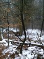
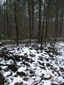
Just as planned: a nice 90 minutes -tron - walk to cure my hangover. I came along a place that I like very much, the Speyrer Düne (dune of Speyer).
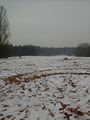
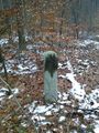
The hash was easy to find, just 10m of my way. I took some photos, made an x with sticks (but forgot to take a picture of that) and went home. As I know the surroundings quite good, I tried a ton, and I think, I succeeded.
Tracklog
Photos
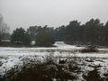
Speyrer Düne
Der Ameisenhügel (the ants hill), the highest dune in Speyer
I obvously left the tottery of Speyer
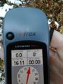
proof
at the hashpoint
the path is just a few meters from the hashpoint

stupid grin


Achievements
DODO earned the Land geohash achievement
|
DODO earned the Walk geohash Achievement
|
DODO earned the Tron achievement
|