Difference between revisions of "2015-01-11 49 8"
imported>DODO (→Participants) |
imported>FippeBot m (Location) |
||
| (6 intermediate revisions by one other user not shown) | |||
| Line 28: | Line 28: | ||
== Plans == | == Plans == | ||
<!-- what were the original plans --> | <!-- what were the original plans --> | ||
| + | I didn't want to go hashing this weekend, but then [[User:Ekorren|Ekorren]] wrote that he is in Heidelberg this weekend, and I wondered if we could meet somewhere. The only possibility was the hash on Sunday, but Ekorren was to busy on Sunday. Nevertheless, some plans has been made and the weather was fine (very windy, quite cold, but sunny at least), and so I decided to do some bull-riding today. | ||
== Expedition == | == Expedition == | ||
<!-- how it all turned out. your narrative goes here. --> | <!-- how it all turned out. your narrative goes here. --> | ||
| + | Not so much to tell: on my way to the hash the wind came from rear and made riding very easy and fast. Soon I reached Malsch, where I see a sign to a crib with living animals. Of course I had to see this, and so a little detour was made. Soon I found a little zoo with no fee and so I entered and found some birds, some more small animals and a crib with two donkeys and some goats. I took some photos and continued my ride. After a while I came near the hashpoint and could ride up to 100m to it. I tethered my mount and walked for a short while. Soon I saw a very muddy fresh ploughed field. I walked along it but couldn't get nearer than 25 m without going into it. I hesitated for a while but then I went into it. It was not as bad as it looked like. Without any dancing I reached a 0. Happy about that I took some photos and quickly walked back. The good luck from the way to the hash turned now, as the wind came from the front for the way home, but with the help of my bull I made it anyway (although we are both very exhausted now). | ||
== Tracklog == | == Tracklog == | ||
<!-- if your GPS device keeps a log, you may post a link here --> | <!-- if your GPS device keeps a log, you may post a link here --> | ||
| + | [https://www.komoot.de/tour/4171931 70km bullriding] | ||
== Photos == | == Photos == | ||
| Line 40: | Line 43: | ||
--> | --> | ||
<gallery perrow="5"> | <gallery perrow="5"> | ||
| + | Image:2015-01-11_49_8-2.jpg | the crib | ||
| + | Image:2015-01-11_49_8-3.jpg | the crib with the donkeys | ||
| + | Image:2015-01-11_49_8-1.jpg | some birds | ||
| + | Image:2015-01-11_49_8-4.jpg | and another one | ||
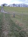
| + | Image:2015-01-11_49_8-5.jpg | the tethered bull | ||
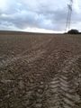
| + | Image:2015-01-11_49_8-6.jpg | only 25 m to go. But in this direction | ||
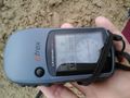
| + | Image:2015-01-11_49_8-7.jpg | proof that I did it | ||
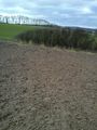
| + | Image:2015-01-11_49_8-8.jpg | the way I walked | ||
| + | Image:2015-01-11_49_8-9.jpg | anyway lucky geohasher | ||
| + | Image:2015-01-11_49_8-10.jpg | view from the hash to Michelfeld | ||
</gallery> | </gallery> | ||
| Line 45: | Line 58: | ||
{{#vardefine:ribbonwidth|800px}} | {{#vardefine:ribbonwidth|800px}} | ||
<!-- Add any achievement ribbons you earned below, or remove this section --> | <!-- Add any achievement ribbons you earned below, or remove this section --> | ||
| + | {{land geohash | ||
| + | | latitude = 49 | ||
| + | | longitude = 8 | ||
| + | | date = 2015-01-11 | ||
| + | | name = DODO | ||
| + | }} | ||
| − | |||
| − | |||
| − | |||
| − | |||
| − | |||
| − | |||
| − | |||
| − | |||
| − | |||
| − | |||
[[Category:Expeditions]] | [[Category:Expeditions]] | ||
| − | |||
[[Category:Expeditions with photos]] | [[Category:Expeditions with photos]] | ||
| − | |||
| − | |||
| − | |||
| − | |||
| − | |||
[[Category:Coordinates reached]] | [[Category:Coordinates reached]] | ||
| − | + | {{location|DE|BW|HD}} | |
| − | |||
| − | |||
| − | |||
| − | |||
| − | |||
| − | |||
| − | |||
| − | |||
| − | |||
| − | |||
| − | |||
| − | |||
| − | |||
| − | |||
| − | |||
| − | |||
| − | |||
Latest revision as of 02:23, 15 August 2019
| Sun 11 Jan 2015 in 49,8: 49.2192347, 8.7727021 geohashing.info google osm bing/os kml crox |
Location
A field near Angelbachtal-Michelfeld
Participants
Plans
I didn't want to go hashing this weekend, but then Ekorren wrote that he is in Heidelberg this weekend, and I wondered if we could meet somewhere. The only possibility was the hash on Sunday, but Ekorren was to busy on Sunday. Nevertheless, some plans has been made and the weather was fine (very windy, quite cold, but sunny at least), and so I decided to do some bull-riding today.
Expedition
Not so much to tell: on my way to the hash the wind came from rear and made riding very easy and fast. Soon I reached Malsch, where I see a sign to a crib with living animals. Of course I had to see this, and so a little detour was made. Soon I found a little zoo with no fee and so I entered and found some birds, some more small animals and a crib with two donkeys and some goats. I took some photos and continued my ride. After a while I came near the hashpoint and could ride up to 100m to it. I tethered my mount and walked for a short while. Soon I saw a very muddy fresh ploughed field. I walked along it but couldn't get nearer than 25 m without going into it. I hesitated for a while but then I went into it. It was not as bad as it looked like. Without any dancing I reached a 0. Happy about that I took some photos and quickly walked back. The good luck from the way to the hash turned now, as the wind came from the front for the way home, but with the help of my bull I made it anyway (although we are both very exhausted now).
Tracklog
Photos
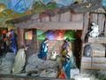
the crib
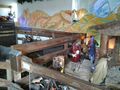
the crib with the donkeys
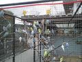
some birds
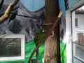
and another one
the tethered bull
only 25 m to go. But in this direction
proof that I did it
the way I walked
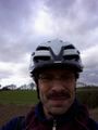
anyway lucky geohasher
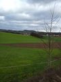
view from the hash to Michelfeld


Achievements
DODO earned the Land geohash achievement
|